Property Record
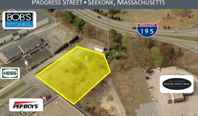
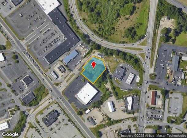
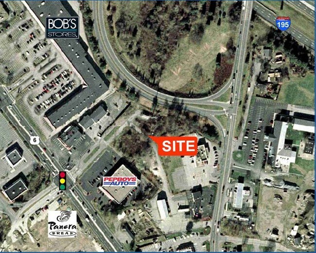
Progress St, Seekonk, MA 02771
Property Detail
Progress St
SEEK-000080-000000-001160
Bristol
Commercialacreage
Massachusetts
X
1160
25005C0212F
0.84 AC
2025
Attleboro/New Bedford
2025
Boston
632100
Providence-Warwick, RI-MA
NEARBY LISTINGS FOR SALE OR LEASE
DEMOGRAPHICS near Progress St
1 mile
3 mile
5 mile
2024 Total Population
3,889
51,752
189,701
2029 Population
3,880
51,520
188,901
Pop Growth 2024-2029
(0.23%)
(0.45%)
(0.42%)
Average Age
41
43
40
2024 Total Households
1,583
22,006
76,389
HH Growth 2024-2029
(0.25%)
(0.53%)
(0.27%)
Median Household Inc
$76,554
$73,838
$71,196
Avg Household Size
2.40
2.30
2.30
2024 Avg HH Vehicles
2.00
2.00
2.00
Median Home Value
$428,022
$311,962
$354,285
Median Year Built
1975
1959
1951
Nearby Places
Map Layers
Map Styles
 Street
 Aerial
Transit
 Traffic
 Biking
Places
Listings with unknown addresses are not visible on the map
- Restaurants
- Banks
- Shops
- Fitness
- Groceries
PUBLIC TRANSPORTATION
COMMUTER RAIL
Providence (Providence/Stoughton Line - Massachusetts Bay Transportation Authority Commuter Rail (Purple Line))
Drive
Walk
Distance
Providence (Providence/Stoughton Line - Massachusetts Bay Transportation Authority Commuter Rail (Purple Line))
9 min
5.1 mi
Drive
Walk
Distance
14 min
7.8 mi
AIRPORT
Rhode Island Tf Green International
Drive
Walk
Distance
Rhode Island Tf Green International
23 min
12.0 mi
Worcester Regional
Drive
Walk
Distance
Worcester Regional
67 min
49.3 mi
Freight Ports
Port of Davisville, RI
Drive
Walk
Distance
Port of Davisville, RI
39 min
24.3 mi
Nearby Properties
Address
Land Use
TOTAL SIZE
Lot Size
Zoning
Address
Land Use
TOTAL SIZE
Lot Size
Zoning
317,728 SF
28.20 AC
O1
Address
Land Use
TOTAL SIZE
Lot Size
Zoning
Address
Land Use
TOTAL SIZE
Lot Size
Zoning
15.20 AC
R5
Address
Land Use
TOTAL SIZE
Lot Size
Zoning
455.47 AC
I3
Address
Land Use
TOTAL SIZE
Lot Size
Zoning
139.58 AC
O1
Address
Land Use
TOTAL SIZE
Lot Size
Zoning
225,067 SF
40.70 AC
HB
Address
Land Use
TOTAL SIZE
Lot Size
Zoning
8.05 AC
C1
Address
Land Use
TOTAL SIZE
Lot Size
Zoning
Address
Land Use
TOTAL SIZE
Lot Size
Zoning
18.01 AC
C3
Address
Land Use
TOTAL SIZE
Lot Size
Zoning
248,000 SF
75.88 AC
I
Address
Land Use
TOTAL SIZE
Lot Size
Zoning
4.62 AC
R5
Address
Land Use
TOTAL SIZE
Lot Size
Zoning
12.67 AC
R5
Address
Land Use
TOTAL SIZE
Lot Size
Zoning
170,345 SF
3.76 AC
R6
Address
Land Use
TOTAL SIZE
Lot Size
Zoning
171,290 SF
27.80 AC
R2
Address
Land Use
TOTAL SIZE
Lot Size
Zoning
53.20 AC
C1
Address
Land Use
TOTAL SIZE
Lot Size
Zoning
225,458 SF
24.95 AC
I1
Address
Land Use
TOTAL SIZE
Lot Size
Zoning
223,374 SF
14 AC
O1
Address
Land Use
TOTAL SIZE
Lot Size
Zoning
87,544 SF
5.05 AC
KP
Address
Land Use
TOTAL SIZE
Lot Size
Zoning
7.44 AC
R5
Address
Land Use
TOTAL SIZE
Lot Size
Zoning
17.24 AC
W-3
Address
Land Use
TOTAL SIZE
Lot Size
Zoning
105,859 SF
16.08 AC
HB
Address
Land Use
TOTAL SIZE
Lot Size
Zoning
105,859 SF
16.08 AC
HB
Address
Land Use
TOTAL SIZE
Lot Size
Zoning
139,692 SF
15.92 AC
HB
Address
Land Use
TOTAL SIZE
Lot Size
Zoning
128,578 SF
38.89 AC
O1
Address
Land Use
TOTAL SIZE
Lot Size
Zoning
1.29 AC
R5
Address
Land Use
TOTAL SIZE
Lot Size
Zoning
9.81 AC
R5
Address
Land Use
TOTAL SIZE
Lot Size
Zoning
Address
Land Use
TOTAL SIZE
Lot Size
Zoning
126,183 SF
13.02 AC
HB
Address
Land Use
TOTAL SIZE
Lot Size
Zoning
133,632 SF
17.49 AC
I3
Address
Land Use
TOTAL SIZE
Lot Size
Zoning
21.48 AC
O1
The World's #1 Commercial Real Estate Marketplace
Connect with us
© 2026 CoStar Group
The information above has been obtained from sources believed reliable. While we do not doubt its accuracy we have not verified it and make no guarantee, warranty or representation about it. It is your responsibility to independently confirm its accuracy and completeness. Any projections, opinions, assumptions, or estimates used are for example only and do not represent the current or future performance of the property. The value of this transaction to you depends on tax and other factors which should be evaluated by your tax, financial, and legal advisors. You and your advisors should conduct a careful, independent investigation of the property to determine to your satisfaction the suitability of the property for your needs.