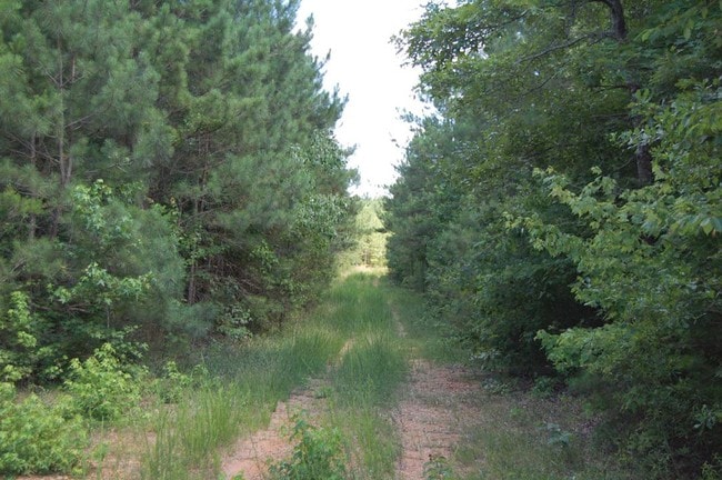
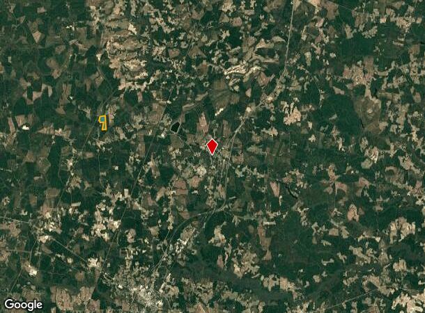
Property Record
Purdy Rd, Jarratt, VA 23867
NEARBY LISTINGS FOR SALE OR LEASE
-
-
View all Jarratt listings for sale on LoopNet.com
Property Detail
Purdy Rd
4-2-1
TRACT 1- E & S SD ST HWY 619 PURDY ROAD (TRACT 988A) INST 170001194 & 060002044 109.8 ACRES
Vacantlandnec
Greensville
X
Virginia
51081C0100C
109.80 AC
2024
Virginia Regional
2024
Other Market Areas
880101
DEMOGRAPHICS near Purdy Rd
1 Mile
3 Mile
5 Mile
2024 Total Population
40
336
904
2029 Population
39
327
883
Pop Growth 2024-2029
(2.50%)
(2.68%)
(2.32%)
Average Age
44
44
44
2024 Total Households
16
140
375
HH Growth 2024-2029
0.00%
(2.86%)
(2.40%)
Median Household Inc
$99,999
$96,093
$87,755
Avg Household Size
2.40
2.30
2.30
2024 Avg HH Vehicles
3.00
3.00
3.00
Median Home Value
$179,999
$172,618
$157,627
Median Year Built
1987
1985
1985
Nearby Places
Map Layers
Map Styles
 Street
 Aerial
- Restaurants
- Banks
- Shops
- Fitness
- Groceries
Nearby Properties
Address
Land Use
TOTAL SIZE
Lot Size
Zoning
Address
Land Use
TOTAL SIZE
Lot Size
Zoning
425.34 AC
A-1
Address
Land Use
TOTAL SIZE
Lot Size
Zoning
17,630 SF
1,105.29 AC
A-1
Address
Land Use
TOTAL SIZE
Lot Size
Zoning
166,543 SF
136.10 AC
M-1
Address
Land Use
TOTAL SIZE
Lot Size
Zoning
414.54 AC
A-1
Address
Land Use
TOTAL SIZE
Lot Size
Zoning
168.77 AC
A-1
Address
Land Use
TOTAL SIZE
Lot Size
Zoning
5.72 AC
Address
Land Use
TOTAL SIZE
Lot Size
Zoning
1.48 AC
M-1
Address
Land Use
TOTAL SIZE
Lot Size
Zoning
130.61 AC
M-1
Address
Land Use
TOTAL SIZE
Lot Size
Zoning
3,000 SF
567.82 AC
Address
Land Use
TOTAL SIZE
Lot Size
Zoning
2.22 AC
Address
Land Use
TOTAL SIZE
Lot Size
Zoning
2,547 SF
7.10 AC
Address
Land Use
TOTAL SIZE
Lot Size
Zoning
1.18 AC
Address
Land Use
TOTAL SIZE
Lot Size
Zoning
0.85 AC
Address
Land Use
TOTAL SIZE
Lot Size
Zoning
0.86 AC
Address
Land Use
TOTAL SIZE
Lot Size
Zoning
6,016 SF
0.55 AC
Address
Land Use
TOTAL SIZE
Lot Size
Zoning
353.96 AC
SPLT
Address
Land Use
TOTAL SIZE
Lot Size
Zoning
7.05 AC
M-1
Address
Land Use
TOTAL SIZE
Lot Size
Zoning
480.20 AC
A-1
Address
Land Use
TOTAL SIZE
Lot Size
Zoning
0.29 AC
A-1
Address
Land Use
TOTAL SIZE
Lot Size
Zoning
7,500 SF
1.72 AC
Address
Land Use
TOTAL SIZE
Lot Size
Zoning
2.89 AC
Address
Land Use
TOTAL SIZE
Lot Size
Zoning
3.22 AC
Address
Land Use
TOTAL SIZE
Lot Size
Zoning
343.59 AC
A-1
Address
Land Use
TOTAL SIZE
Lot Size
Zoning
0.22 AC
Address
Land Use
TOTAL SIZE
Lot Size
Zoning
3,048 SF
1.53 AC
Address
Land Use
TOTAL SIZE
Lot Size
Zoning
474 AC
A-1
Address
Land Use
TOTAL SIZE
Lot Size
Zoning
287.33 AC
A-1
Address
Land Use
TOTAL SIZE
Lot Size
Zoning
1.19 AC
Address
Land Use
TOTAL SIZE
Lot Size
Zoning
0.40 AC
Address
Land Use
TOTAL SIZE
Lot Size
Zoning
The World's #1 Commercial Real Estate Marketplace
Connect with us
© 2025 CoStar Group
The information above has been obtained from sources believed reliable. While we do not doubt its accuracy we have not verified it and make no guarantee, warranty or representation about it. It is your responsibility to independently confirm its accuracy and completeness. Any projections, opinions, assumptions, or estimates used are for example only and do not represent the current or future performance of the property. The value of this transaction to you depends on tax and other factors which should be evaluated by your tax, financial, and legal advisors. You and your advisors should conduct a careful, independent investigation of the property to determine to your satisfaction the suitability of the property for your needs.