Property Record
Pyramid Way, Reno, NV 89510

Save to a Folder
{{folder.Name}}
{{folder.ListingIds.length}} Properties
{{folder.ListingIds.length}} Property
Create a New Folder
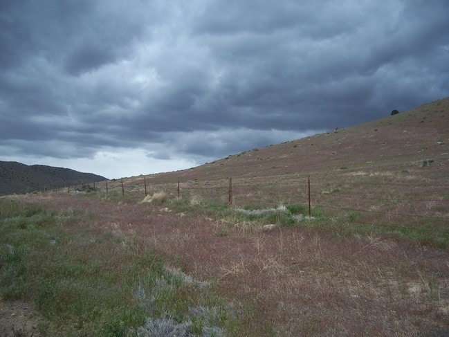
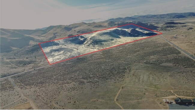
Property Detail
Pyramid Way
Reno, NV
DLM 131 LT 2
076-261-05
WASHOE
Residentialacreage
Nevada
GRA
2
B and X Area of moderate flood hazard, usually the area between the limits of the 100-year and 500-year floods.
63.92 AC
2025
N Outlying Washoe County
2026
Reno/Sparks
003501
NEARBY LISTINGS FOR SALE OR LEASE
-
-
View all Reno listings for sale on LoopNet.com
DEMOGRAPHICS near Pyramid Way
1 mile
3 mile
5 mile
2025 Total Population
57
485
1,638
2030 Population
61
518
1,742
Pop Growth 2025-2030
+ 7.02%
+ 6.80%
+ 6.35%
Average Age
45
45
45
2025 Total Households
20
172
574
HH Growth 2025-2030
+ 5.00%
+ 6.40%
+ 6.62%
Median Household Inc
$99,999
$97,580
$102,902
Avg Household Size
2.70
2.60
2.70
2025 Avg HH Vehicles
3.00
3.00
3.00
Median Home Value
$681,818
$683,673
$714,285
Median Year Built
1998
1999
2001
Nearby Places
Map Layers
Map Styles
 Street
 Aerial
Layers
 Traffic
 Biking
Places
Listings with unknown addresses are not visible on the map
- Restaurants
- Banks
- Shops
- Fitness
- Groceries
PUBLIC TRANSPORTATION
AIRPORT
Reno/Tahoe International
Drive
Walk
Distance
Reno/Tahoe International
47 min
24.4 mi
Freight Ports
Port of Stockton
Drive
Walk
Distance
Port of Stockton
233 min
198.7 mi
SALE & LEASE HISTORY
LISTING DATE
SALE/LEASE

May 16, 2018
For Sale
Apr 29, 2020
For Sale
Nearby Properties
Address
Land Use
TOTAL SIZE
Lot Size
Zoning
Address
Land Use
TOTAL SIZE
Lot Size
Zoning
75,629 SF
38.78 AC
NC 14% / M
Address
Land Use
TOTAL SIZE
Lot Size
Zoning
1,440 SF
148.15 AC
PSP
Address
Land Use
TOTAL SIZE
Lot Size
Zoning
3,528 SF
2.14 AC
NC
Address
Land Use
TOTAL SIZE
Lot Size
Zoning
4,900 SF
76.99 AC
GRA
Address
Land Use
TOTAL SIZE
Lot Size
Zoning
40.13 AC
GRA
Address
Land Use
TOTAL SIZE
Lot Size
Zoning
652.59 AC
OS
Address
Land Use
TOTAL SIZE
Lot Size
Zoning
78.24 AC
GRA
Address
Land Use
TOTAL SIZE
Lot Size
Zoning
3,200 SF
72.86 AC
GRA
Address
Land Use
TOTAL SIZE
Lot Size
Zoning
77.78 AC
GRA
Address
Land Use
TOTAL SIZE
Lot Size
Zoning
152 AC
GRA
Address
Land Use
TOTAL SIZE
Lot Size
Zoning
67.92 AC
GRA
Address
Land Use
TOTAL SIZE
Lot Size
Zoning
42.25 AC
GRA
Address
Land Use
TOTAL SIZE
Lot Size
Zoning
40 AC
GRA
Address
Land Use
TOTAL SIZE
Lot Size
Zoning
86.64 AC
GRA
Address
Land Use
TOTAL SIZE
Lot Size
Zoning
41.96 AC
GRA
Address
Land Use
TOTAL SIZE
Lot Size
Zoning
95.68 AC
GRA 88% /
Address
Land Use
TOTAL SIZE
Lot Size
Zoning
74.48 AC
GRA
Address
Land Use
TOTAL SIZE
Lot Size
Zoning
45.45 AC
NC 32% / M
Address
Land Use
TOTAL SIZE
Lot Size
Zoning
45.57 AC
NC 85% / G
Address
Land Use
TOTAL SIZE
Lot Size
Zoning
77.65 AC
GRA
Address
Land Use
TOTAL SIZE
Lot Size
Zoning
198.13 AC
GRA
Address
Land Use
TOTAL SIZE
Lot Size
Zoning
73.14 AC
GRA
Address
Land Use
TOTAL SIZE
Lot Size
Zoning
80.76 AC
GRA
Address
Land Use
TOTAL SIZE
Lot Size
Zoning
3,258 SF
44.53 AC
GRA
Address
Land Use
TOTAL SIZE
Lot Size
Zoning
37.28 AC
GRA
Address
Land Use
TOTAL SIZE
Lot Size
Zoning
41.80 AC
GRA
Address
Land Use
TOTAL SIZE
Lot Size
Zoning
56.39 AC
GRA
Address
Land Use
TOTAL SIZE
Lot Size
Zoning
45.54 AC
GRA
Address
Land Use
TOTAL SIZE
Lot Size
Zoning
40.04 AC
GRA
Address
Land Use
TOTAL SIZE
Lot Size
Zoning
41.33 AC
GRA
The World's #1 Commercial Real Estate Marketplace
Connect with us
© 2026 CoStar Group
The information above has been obtained from sources believed reliable. While we do not doubt its accuracy we have not verified it and make no guarantee, warranty or representation about it. It is your responsibility to independently confirm its accuracy and completeness. Any projections, opinions, assumptions, or estimates used are for example only and do not represent the current or future performance of the property. The value of this transaction to you depends on tax and other factors which should be evaluated by your tax, financial, and legal advisors. You and your advisors should conduct a careful, independent investigation of the property to determine to your satisfaction the suitability of the property for your needs.