Property Record
Friars Rd, San Diego, CA 92108
Current Lease Availabilities
NEARBY LISTINGS FOR SALE OR LEASE
Property Detail
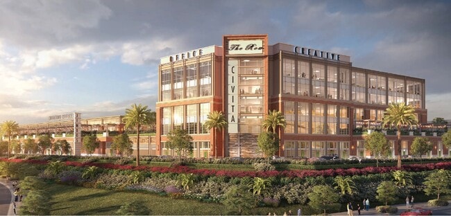
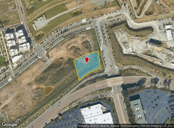
Friars Rd
San Diego-Chula Vista-Carlsbad, CA
LOT 10 TR 016000
677-420-21
San Diego
Multifamilydwelling
California
X
10
06073C1619G
1.41 AC
2024
Mission Valley
2025
San Diego
009307
DEMOGRAPHICS near Friars Rd
1 Mile
3 Mile
5 Mile
2024 Total Population
18,415
218,867
523,466
2029 Population
18,593
218,989
522,963
Pop Growth 2024-2029
+ 0.97%
+ 0.06%
(0.10%)
Average Age
38
38
38
2024 Total Households
9,133
99,943
223,285
HH Growth 2024-2029
+ 1.07%
(0.01%)
(0.05%)
Median Household Inc
$101,337
$84,587
$81,438
Avg Household Size
2.00
2.10
2.20
2024 Avg HH Vehicles
2.00
2.00
2.00
Median Home Value
$732,302
$747,056
$762,869
Median Year Built
2003
1975
1975
Nearby Places
Map Layers
Map Styles
 Street
 Aerial
- Restaurants
- Banks
- Shops
- Fitness
- Groceries
PUBLIC TRANSPORTATION
TRANSIT/SUBWAY
Rio Vista (Green Line - San Diego Metropolitan Transit System Trolley (San Diego Trolley))
DRIVE
WALK
Distance
Rio Vista (Green Line - San Diego Metropolitan Transit System Trolley (San Diego Trolley))
4 min
8 min
0.4 mi
COMMUTER RAIL
Old Town Transit Center (Coaster - San Diego North County Transit District (Coaster/Sprinter/Breeze))
DRIVE
WALK
Distance
Old Town Transit Center (Coaster - San Diego North County Transit District (Coaster/Sprinter/Breeze))
9 min
4.9 mi
San Diego (Santa Fe Depot) (Coaster - San Diego North County Transit District (Coaster/Sprinter/Breeze))
DRIVE
WALK
Distance
San Diego (Santa Fe Depot) (Coaster - San Diego North County Transit District (Coaster/Sprinter/Breeze))
10 min
6.4 mi
AIRPORT
San Diego International
DRIVE
WALK
Distance
San Diego International
11 min
5.4 mi
Nearby Properties
Address
Land Use
TOTAL SIZE
Lot Size
Zoning
Address
Land Use
TOTAL SIZE
Lot Size
Zoning
30,000 SF
62.51 AC
MVPD-MV-CR
Address
Land Use
TOTAL SIZE
Lot Size
Zoning
4,774 SF
74.75 AC
RM-2-5
Address
Land Use
TOTAL SIZE
Lot Size
Zoning
189,644 SF
20.49 AC
CO-1-2
Address
Land Use
TOTAL SIZE
Lot Size
Zoning
17.88 AC
CO-1-2
Address
Land Use
TOTAL SIZE
Lot Size
Zoning
12.97 AC
RM-3-7
Address
Land Use
TOTAL SIZE
Lot Size
Zoning
46.03 AC
IH-2-1
Address
Land Use
TOTAL SIZE
Lot Size
Zoning
2.53 AC
EMX-1
Address
Land Use
TOTAL SIZE
Lot Size
Zoning
4.41 AC
CC-3-8
Address
Land Use
TOTAL SIZE
Lot Size
Zoning
1.51 AC
CC-3-9
Address
Land Use
TOTAL SIZE
Lot Size
Zoning
6.96 AC
MVPD-MVR-4
Address
Land Use
TOTAL SIZE
Lot Size
Zoning
18.70 AC
RS-1-7
Address
Land Use
TOTAL SIZE
Lot Size
Zoning
19.25 AC
CC-3-5
Address
Land Use
TOTAL SIZE
Lot Size
Zoning
15.37 AC
CC-3-8
Address
Land Use
TOTAL SIZE
Lot Size
Zoning
5.02 AC
CC-3-8
Address
Land Use
TOTAL SIZE
Lot Size
Zoning
7.48 AC
RM-3-9
Address
Land Use
TOTAL SIZE
Lot Size
Zoning
54,240 SF
8.18 AC
MVPD-MVR-2
Address
Land Use
TOTAL SIZE
Lot Size
Zoning
2.50 AC
MVPD-MV-CO
Address
Land Use
TOTAL SIZE
Lot Size
Zoning
5.35 AC
MVPD-MV-CR
Address
Land Use
TOTAL SIZE
Lot Size
Zoning
3.97 AC
C
Address
Land Use
TOTAL SIZE
Lot Size
Zoning
7.69 AC
MVPD-MV-M/
Address
Land Use
TOTAL SIZE
Lot Size
Zoning
13.04 AC
RM-2-5
Address
Land Use
TOTAL SIZE
Lot Size
Zoning
7.19 AC
MVPD-MV-M/
Address
Land Use
TOTAL SIZE
Lot Size
Zoning
17.35 AC
C-6
Address
Land Use
TOTAL SIZE
Lot Size
Zoning
902,919 SF
45.23 AC
MVPD-MV-CR
Address
Land Use
TOTAL SIZE
Lot Size
Zoning
5.39 AC
CO-1-2
Address
Land Use
TOTAL SIZE
Lot Size
Zoning
2.90 AC
MVPD-MV-CR
Address
Land Use
TOTAL SIZE
Lot Size
Zoning
1.99 AC
EMX-1
Address
Land Use
TOTAL SIZE
Lot Size
Zoning
1.81 AC
EMX-1
Address
Land Use
TOTAL SIZE
Lot Size
Zoning
16.91 AC
EMX-1
Address
Land Use
TOTAL SIZE
Lot Size
Zoning
3.36 AC
RM-4-10
The World's #1 Commercial Real Estate Marketplace
Connect with us
© 2026 CoStar Group
The information above has been obtained from sources believed reliable. While we do not doubt its accuracy we have not verified it and make no guarantee, warranty or representation about it. It is your responsibility to independently confirm its accuracy and completeness. Any projections, opinions, assumptions, or estimates used are for example only and do not represent the current or future performance of the property. The value of this transaction to you depends on tax and other factors which should be evaluated by your tax, financial, and legal advisors. You and your advisors should conduct a careful, independent investigation of the property to determine to your satisfaction the suitability of the property for your needs.