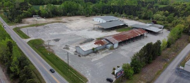
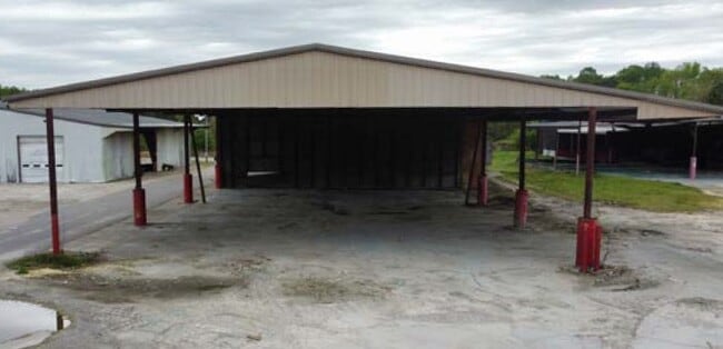
Property Record
Raleigh Rd, Henderson, NC 27537

Current Lease Availabilities
Property Detail
Raleigh Rd
0221-03018
2760 RALEIGH RD 11.920
Officebuilding
VANCE
HI2
North Carolina
B and X Area of moderate flood hazard, usually the area between the limits of the 100-year and 500-year floods.
11.92 AC
2025
North Carolina Northeast Area
2025
Other Market Areas
960600
Henderson, NC
2,305 SF
NEARBY LISTINGS FOR SALE OR LEASE
DEMOGRAPHICS near Raleigh Rd
1 mile
3 mile
5 mile
2025 Total Population
1,151
17,973
27,917
2030 Population
1,175
18,055
28,028
Pop Growth 2025-2030
+ 2.09%
+ 0.46%
+ 0.40%
Average Age
40
40
41
2025 Total Households
470
7,120
11,129
HH Growth 2025-2030
+ 1.91%
+ 0.44%
+ 0.37%
Median Household Inc
$36,842
$41,289
$44,658
Avg Household Size
2.40
2.40
2.40
2025 Avg HH Vehicles
1.00
2.00
2.00
Median Home Value
$101,667
$132,216
$147,377
Median Year Built
1973
1971
1975
Nearby Places
Map Layers
Map Styles
 Street
 Aerial
Layers
 Traffic
 Biking
Places
Listings with unknown addresses are not visible on the map
- Restaurants
- Banks
- Shops
- Fitness
- Groceries
Nearby Properties
Address
Land Use
TOTAL SIZE
Lot Size
Zoning
Address
Land Use
TOTAL SIZE
Lot Size
Zoning
149,688 SF
131.64 AC
HI2
Address
Land Use
TOTAL SIZE
Lot Size
Zoning
96,081 SF
1.33 AC
HB1
Address
Land Use
TOTAL SIZE
Lot Size
Zoning
603,204 SF
45.50 AC
HI2
Address
Land Use
TOTAL SIZE
Lot Size
Zoning
51,768 SF
40.75 AC
HR8M
Address
Land Use
TOTAL SIZE
Lot Size
Zoning
64,208 SF
1.90 AC
HB1
Address
Land Use
TOTAL SIZE
Lot Size
Zoning
167,900 SF
70.82 AC
HR15
Address
Land Use
TOTAL SIZE
Lot Size
Zoning
230,400 SF
69.68 AC
HI2
Address
Land Use
TOTAL SIZE
Lot Size
Zoning
22,572 SF
88.80 AC
HR15M
Address
Land Use
TOTAL SIZE
Lot Size
Zoning
214,900 SF
25.24 AC
HI2
Address
Land Use
TOTAL SIZE
Lot Size
Zoning
24,888 SF
33.39 AC
HR20
Address
Land Use
TOTAL SIZE
Lot Size
Zoning
150,320 SF
9.51 AC
HB3
Address
Land Use
TOTAL SIZE
Lot Size
Zoning
158,500 SF
18.56 AC
LI
Address
Land Use
TOTAL SIZE
Lot Size
Zoning
85,355 SF
13.80 AC
HB4
Address
Land Use
TOTAL SIZE
Lot Size
Zoning
257,656 SF
31.28 AC
HI2
Address
Land Use
TOTAL SIZE
Lot Size
Zoning
27,784 SF
2.04 AC
HB1
Address
Land Use
TOTAL SIZE
Lot Size
Zoning
78,661 SF
4.84 AC
HOI
Address
Land Use
TOTAL SIZE
Lot Size
Zoning
19,596 SF
7.60 AC
HR15M
Address
Land Use
TOTAL SIZE
Lot Size
Zoning
21,548 SF
13.77 AC
Address
Land Use
TOTAL SIZE
Lot Size
Zoning
56,315 SF
8.69 AC
HB4
Address
Land Use
TOTAL SIZE
Lot Size
Zoning
48,490 SF
6.14 AC
HB2A
Address
Land Use
TOTAL SIZE
Lot Size
Zoning
27,344 SF
23.26 AC
HR15M
Address
Land Use
TOTAL SIZE
Lot Size
Zoning
109,130 SF
26.76 AC
Address
Land Use
TOTAL SIZE
Lot Size
Zoning
62,129 SF
26.02 AC
OI
Address
Land Use
TOTAL SIZE
Lot Size
Zoning
40,456 SF
2 AC
HB3
Address
Land Use
TOTAL SIZE
Lot Size
Zoning
12,000 SF
1.50 AC
HI2
Address
Land Use
TOTAL SIZE
Lot Size
Zoning
55,900 SF
16.19 AC
Address
Land Use
TOTAL SIZE
Lot Size
Zoning
15,344 SF
3.38 AC
R30
Address
Land Use
TOTAL SIZE
Lot Size
Zoning
65,156 SF
46.85 AC
HI2
Address
Land Use
TOTAL SIZE
Lot Size
Zoning
213,673 SF
8.05 AC
HI2
Address
Land Use
TOTAL SIZE
Lot Size
Zoning
14,672 SF
2.85 AC
HB4
The World's #1 Commercial Real Estate Marketplace
Connect with us
© 2026 CoStar Group
The information above has been obtained from sources believed reliable. While we do not doubt its accuracy we have not verified it and make no guarantee, warranty or representation about it. It is your responsibility to independently confirm its accuracy and completeness. Any projections, opinions, assumptions, or estimates used are for example only and do not represent the current or future performance of the property. The value of this transaction to you depends on tax and other factors which should be evaluated by your tax, financial, and legal advisors. You and your advisors should conduct a careful, independent investigation of the property to determine to your satisfaction the suitability of the property for your needs.