Property Record
Raleigh Rd W, Wilson, NC 27896
NEARBY LISTINGS FOR SALE OR LEASE
Property Detail
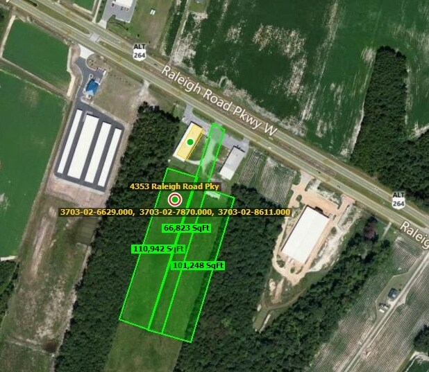
Raleigh Rd W
3703-02-8611.000
RALEIGH ROAD PKWY W 2.40AC
Residentialacreage
Wilson
X
North Carolina
3720370300K
2.40 AC
2024
Rocky Mount/Wilson
2025
Other Market Areas
001402
Wilson, NC
DEMOGRAPHICS near Raleigh Rd W
1 Mile
3 Mile
5 Mile
2024 Total Population
845
16,838
44,905
2029 Population
862
16,957
45,045
Pop Growth 2024-2029
+ 2.01%
+ 0.71%
+ 0.31%
Average Age
37
40
41
2024 Total Households
355
7,035
18,763
HH Growth 2024-2029
+ 1.97%
+ 0.70%
+ 0.27%
Median Household Inc
$51,687
$55,467
$52,949
Avg Household Size
2.40
2.40
2.30
2024 Avg HH Vehicles
2.00
2.00
2.00
Median Home Value
$148,584
$165,865
$161,450
Median Year Built
2001
1993
1986
Nearby Places
Map Layers
Map Styles
 Street
 Aerial
- Restaurants
- Banks
- Shops
- Fitness
- Groceries
PUBLIC TRANSPORTATION
COMMUTER RAIL
Wilson (Carolinian - Amtrak, Palmetto - Amtrak)
DRIVE
WALK
Distance
Wilson (Carolinian - Amtrak, Palmetto - Amtrak)
10 min
5.7 mi
Freight Ports
Port of Morehead City
DRIVE
WALK
Distance
Port of Morehead City
173 min
131.6 mi
Nearby Properties
Address
Land Use
TOTAL SIZE
Lot Size
Zoning
Address
Land Use
TOTAL SIZE
Lot Size
Zoning
125,586 SF
61.33 AC
HI
Address
Land Use
TOTAL SIZE
Lot Size
Zoning
25,554 SF
18.75 AC
RMX
Address
Land Use
TOTAL SIZE
Lot Size
Zoning
624 SF
216.49 AC
M2
Address
Land Use
TOTAL SIZE
Lot Size
Zoning
232,805 SF
49.53 AC
HI
Address
Land Use
TOTAL SIZE
Lot Size
Zoning
14,520 SF
642.25 AC
HI
Address
Land Use
TOTAL SIZE
Lot Size
Zoning
159,765 SF
74.19 AC
AR
Address
Land Use
TOTAL SIZE
Lot Size
Zoning
11,375 SF
29.21 AC
HI
Address
Land Use
TOTAL SIZE
Lot Size
Zoning
4,803 SF
10.23 AC
RMX
Address
Land Use
TOTAL SIZE
Lot Size
Zoning
98,777 SF
50 AC
ICD
Address
Land Use
TOTAL SIZE
Lot Size
Zoning
338,739 SF
29.79 AC
HI
Address
Land Use
TOTAL SIZE
Lot Size
Zoning
185,515 SF
19.58 AC
HC
Address
Land Use
TOTAL SIZE
Lot Size
Zoning
11,664 SF
10.13 AC
HC
Address
Land Use
TOTAL SIZE
Lot Size
Zoning
11,760 SF
56.76 AC
ICD
Address
Land Use
TOTAL SIZE
Lot Size
Zoning
135,620 SF
31.85 AC
HI
Address
Land Use
TOTAL SIZE
Lot Size
Zoning
78,875 SF
34.82 AC
ICD
Address
Land Use
TOTAL SIZE
Lot Size
Zoning
111,191 SF
10.64 AC
B4
Address
Land Use
TOTAL SIZE
Lot Size
Zoning
133,549 SF
21.49 AC
HC
Address
Land Use
TOTAL SIZE
Lot Size
Zoning
9,611 SF
12 AC
ICD
Address
Land Use
TOTAL SIZE
Lot Size
Zoning
27,488 SF
17.21 AC
GR6
Address
Land Use
TOTAL SIZE
Lot Size
Zoning
12,560 SF
11.89 AC
HC
Address
Land Use
TOTAL SIZE
Lot Size
Zoning
1,942 SF
28.23 AC
HI
Address
Land Use
TOTAL SIZE
Lot Size
Zoning
7,350 SF
9.09 AC
GC
Address
Land Use
TOTAL SIZE
Lot Size
Zoning
17,136 SF
9.81 AC
GC
Address
Land Use
TOTAL SIZE
Lot Size
Zoning
30,676 SF
9.09 AC
GC
Address
Land Use
TOTAL SIZE
Lot Size
Zoning
43,522 SF
28.26 AC
ICD
Address
Land Use
TOTAL SIZE
Lot Size
Zoning
17,859 SF
8 AC
SR4
Address
Land Use
TOTAL SIZE
Lot Size
Zoning
8,800 SF
7.51 AC
GC
Address
Land Use
TOTAL SIZE
Lot Size
Zoning
6,312 SF
10.97 AC
GC
Address
Land Use
TOTAL SIZE
Lot Size
Zoning
35,448 SF
5.71 AC
GC
Address
Land Use
TOTAL SIZE
Lot Size
Zoning
71,781 SF
26.09 AC
HC
The World's #1 Commercial Real Estate Marketplace
Connect with us
© 2025 CoStar Group
The information above has been obtained from sources believed reliable. While we do not doubt its accuracy we have not verified it and make no guarantee, warranty or representation about it. It is your responsibility to independently confirm its accuracy and completeness. Any projections, opinions, assumptions, or estimates used are for example only and do not represent the current or future performance of the property. The value of this transaction to you depends on tax and other factors which should be evaluated by your tax, financial, and legal advisors. You and your advisors should conduct a careful, independent investigation of the property to determine to your satisfaction the suitability of the property for your needs.