Property Record
Ralph Fair Rd, Boerne, TX 78015
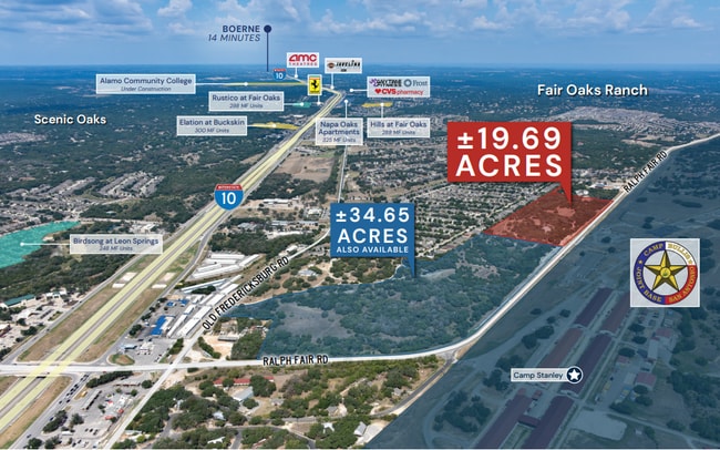
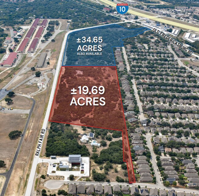
This Property Is For Sale
Property Detail
Ralph Fair Rd
San Antonio-New Braunfels, TX
CB 4733 P-1L (14.045 AC) 2020 SPLIT PER DEED 20190164765 FILED 8-21-19 CR 48435. JA/GIS/2-27-20 2011-MERGED PIDS 1056436 & 1056437 PER OWNER REQUEST CR#24018
04733-000-0018
BEXAR
Privatepreserveopenspacevacantlandforestlandconservation
Texas
B and X Area of moderate flood hazard, usually the area between the limits of the 100-year and 500-year floods.
14.05 AC
2024
Far Northwest
2025
San Antonio
182101
NEARBY LISTINGS FOR SALE OR LEASE
DEMOGRAPHICS near Ralph Fair Rd
1 mile
3 mile
5 mile
2025 Total Population
5,291
32,774
59,357
2030 Population
5,661
34,868
63,690
Pop Growth 2025-2030
+ 6.99%
+ 6.39%
+ 7.30%
Average Age
38
38
39
2025 Total Households
1,816
11,240
21,748
HH Growth 2025-2030
+ 6.94%
+ 6.57%
+ 7.54%
Median Household Inc
$144,750
$142,137
$134,383
Avg Household Size
2.90
2.90
2.70
2025 Avg HH Vehicles
2.00
2.00
2.00
Median Home Value
$479,509
$486,845
$539,214
Median Year Built
2010
2010
2010
Nearby Places
Map Layers
Map Styles
 Street
 Aerial
Layers
 Traffic
 Biking
Places
Listings with unknown addresses are not visible on the map
- Restaurants
- Banks
- Shops
- Fitness
- Groceries
PUBLIC TRANSPORTATION
AIRPORT
San Antonio International
Drive
Walk
Distance
San Antonio International
25 min
19.4 mi
Freight Ports
Calhoun Port
Drive
Walk
Distance
Calhoun Port
204 min
171.1 mi
Nearby Properties
Address
Land Use
TOTAL SIZE
Lot Size
Zoning
Address
Land Use
TOTAL SIZE
Lot Size
Zoning
Address
Land Use
TOTAL SIZE
Lot Size
Zoning
361,559 SF
20 AC
Address
Land Use
TOTAL SIZE
Lot Size
Zoning
329,035 SF
21.28 AC
Address
Land Use
TOTAL SIZE
Lot Size
Zoning
260,536 SF
10.71 AC
Address
Land Use
TOTAL SIZE
Lot Size
Zoning
243,485 SF
9.34 AC
Address
Land Use
TOTAL SIZE
Lot Size
Zoning
282,991 SF
26.41 AC
Address
Land Use
TOTAL SIZE
Lot Size
Zoning
265,093 SF
12.55 AC
Address
Land Use
TOTAL SIZE
Lot Size
Zoning
215,736 SF
10.06 AC
Address
Land Use
TOTAL SIZE
Lot Size
Zoning
49,164 SF
11.98 AC
Address
Land Use
TOTAL SIZE
Lot Size
Zoning
46,562 SF
3.02 AC
Address
Land Use
TOTAL SIZE
Lot Size
Zoning
56,058 SF
8.04 AC
Address
Land Use
TOTAL SIZE
Lot Size
Zoning
68,180 SF
10.22 AC
Address
Land Use
TOTAL SIZE
Lot Size
Zoning
91,013 SF
6.45 AC
Address
Land Use
TOTAL SIZE
Lot Size
Zoning
141,203 SF
12.49 AC
Address
Land Use
TOTAL SIZE
Lot Size
Zoning
147,976 SF
16.48 AC
Address
Land Use
TOTAL SIZE
Lot Size
Zoning
43,422 SF
6.38 AC
Address
Land Use
TOTAL SIZE
Lot Size
Zoning
71,658 SF
16.58 AC
Address
Land Use
TOTAL SIZE
Lot Size
Zoning
45,441 SF
3.84 AC
Address
Land Use
TOTAL SIZE
Lot Size
Zoning
142,425 SF
3.08 AC
Address
Land Use
TOTAL SIZE
Lot Size
Zoning
39,291 SF
4 AC
Address
Land Use
TOTAL SIZE
Lot Size
Zoning
129,911 SF
12.25 AC
Address
Land Use
TOTAL SIZE
Lot Size
Zoning
32,952 SF
2.39 AC
Address
Land Use
TOTAL SIZE
Lot Size
Zoning
35,926 SF
3.71 AC
Address
Land Use
TOTAL SIZE
Lot Size
Zoning
28,398 SF
5.04 AC
Address
Land Use
TOTAL SIZE
Lot Size
Zoning
29,227 SF
3.45 AC
Address
Land Use
TOTAL SIZE
Lot Size
Zoning
21,612 SF
2.98 AC
Address
Land Use
TOTAL SIZE
Lot Size
Zoning
14,644 SF
65.85 AC
Address
Land Use
TOTAL SIZE
Lot Size
Zoning
75,560 SF
3 AC
Address
Land Use
TOTAL SIZE
Lot Size
Zoning
103,963 SF
1.98 AC
Address
Land Use
TOTAL SIZE
Lot Size
Zoning
18,715 SF
2.32 AC
The World's #1 Commercial Real Estate Marketplace
Connect with us
© 2026 CoStar Group
The information above has been obtained from sources believed reliable. While we do not doubt its accuracy we have not verified it and make no guarantee, warranty or representation about it. It is your responsibility to independently confirm its accuracy and completeness. Any projections, opinions, assumptions, or estimates used are for example only and do not represent the current or future performance of the property. The value of this transaction to you depends on tax and other factors which should be evaluated by your tax, financial, and legal advisors. You and your advisors should conduct a careful, independent investigation of the property to determine to your satisfaction the suitability of the property for your needs.