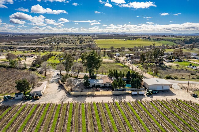
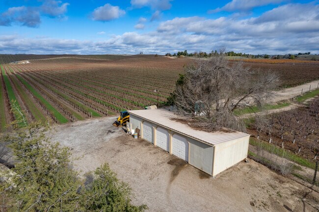
Property Record
Ranchita Canyon Rd, Rural El Pomar Estrella, CA 93451

NEARBY LISTINGS FOR SALE OR LEASE
Property Detail
Ranchita Canyon Rd
San Luis Obispo-Paso Robles-Arroyo Grande, CA
Co95-046
019-071-065
PM 52-36 PAR 1
Agriculturalland
San Luis Obispo
A
California
06079C0425G
61.84 AC
2024
Outlying SLO County
2025
San Luis Obispo/Paso Robles
0103004111
DEMOGRAPHICS near Ranchita Canyon Rd
1 Mile
3 Mile
5 Mile
2024 Total Population
57
1,949
3,693
2029 Population
57
1,919
3,621
Pop Growth 2024-2029
0.00%
(1.54%)
(1.95%)
Average Age
42
41
41
2024 Total Households
20
651
1,260
HH Growth 2024-2029
0.00%
(1.69%)
(2.14%)
Median Household Inc
$95,833
$105,540
$107,353
Avg Household Size
2.70
2.80
2.80
2024 Avg HH Vehicles
3.00
3.00
3.00
Median Home Value
$874,999
$663,086
$671,184
Median Year Built
1986
1991
1991
Nearby Places
Map Layers
Map Styles
 Street
 Aerial
- Restaurants
- Banks
- Shops
- Fitness
- Groceries
PUBLIC TRANSPORTATION
COMMUTER RAIL
Paso Robles Amtrak Station (Coast Starlight - Amtrak)
DRIVE
WALK
Distance
Paso Robles Amtrak Station (Coast Starlight - Amtrak)
16 min
9.7 mi
Freight Ports
The Port of Hueneme
DRIVE
WALK
Distance
The Port of Hueneme
216 min
170.8 mi
SALE & LEASE HISTORY
LISTING DATE
SALE/LEASE

Jan 10, 2022
For Sale
Nearby Properties
Address
Land Use
TOTAL SIZE
Lot Size
Zoning
Address
Land Use
TOTAL SIZE
Lot Size
Zoning
127,770 SF
27.72 AC
AG
Address
Land Use
TOTAL SIZE
Lot Size
Zoning
2,557 SF
9.70 AC
M
Address
Land Use
TOTAL SIZE
Lot Size
Zoning
160 AC
AG
Address
Land Use
TOTAL SIZE
Lot Size
Zoning
149.62 AC
AG
Address
Land Use
TOTAL SIZE
Lot Size
Zoning
137.33 AC
AG
Address
Land Use
TOTAL SIZE
Lot Size
Zoning
94.20 AC
AP
Address
Land Use
TOTAL SIZE
Lot Size
Zoning
Address
Land Use
TOTAL SIZE
Lot Size
Zoning
105.20 AC
AP
Address
Land Use
TOTAL SIZE
Lot Size
Zoning
1,344 SF
78.03 AC
AG
Address
Land Use
TOTAL SIZE
Lot Size
Zoning
77.90 AC
AG
Address
Land Use
TOTAL SIZE
Lot Size
Zoning
285.98 AC
AG
Address
Land Use
TOTAL SIZE
Lot Size
Zoning
87 AC
AG
Address
Land Use
TOTAL SIZE
Lot Size
Zoning
63.89 AC
AG
Address
Land Use
TOTAL SIZE
Lot Size
Zoning
5,886 SF
72.95 AC
AG
Address
Land Use
TOTAL SIZE
Lot Size
Zoning
2.63 AC
AP
Address
Land Use
TOTAL SIZE
Lot Size
Zoning
81.40 AC
AG
Address
Land Use
TOTAL SIZE
Lot Size
Zoning
165.90 AC
AG
Address
Land Use
TOTAL SIZE
Lot Size
Zoning
160 AC
AG
Address
Land Use
TOTAL SIZE
Lot Size
Zoning
161.90 AC
AG
Address
Land Use
TOTAL SIZE
Lot Size
Zoning
8,400 SF
3.71 AC
CR
Address
Land Use
TOTAL SIZE
Lot Size
Zoning
1,395 SF
80 AC
AG
Address
Land Use
TOTAL SIZE
Lot Size
Zoning
37.52 AC
AG
Address
Land Use
TOTAL SIZE
Lot Size
Zoning
1,999 SF
131.50 AC
AG
Address
Land Use
TOTAL SIZE
Lot Size
Zoning
Address
Land Use
TOTAL SIZE
Lot Size
Zoning
155 AC
AG
Address
Land Use
TOTAL SIZE
Lot Size
Zoning
133.60 AC
AG
Address
Land Use
TOTAL SIZE
Lot Size
Zoning
73.02 AC
Address
Land Use
TOTAL SIZE
Lot Size
Zoning
40 AC
AP
Address
Land Use
TOTAL SIZE
Lot Size
Zoning
Address
Land Use
TOTAL SIZE
Lot Size
Zoning
40 AC
AP
The World's #1 Commercial Real Estate Marketplace
Connect with us
© 2026 CoStar Group
The information above has been obtained from sources believed reliable. While we do not doubt its accuracy we have not verified it and make no guarantee, warranty or representation about it. It is your responsibility to independently confirm its accuracy and completeness. Any projections, opinions, assumptions, or estimates used are for example only and do not represent the current or future performance of the property. The value of this transaction to you depends on tax and other factors which should be evaluated by your tax, financial, and legal advisors. You and your advisors should conduct a careful, independent investigation of the property to determine to your satisfaction the suitability of the property for your needs.