Property Record
Rancho Barranco Rd, Laredo, TX 78045

Save to a Folder
{{folder.Name}}
{{folder.ListingIds.length}} Properties
{{folder.ListingIds.length}} Property
Create a New Folder
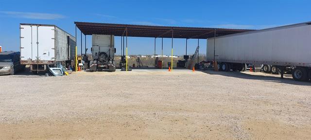
Property Detail
Rancho Barranco Rd
Laredo, TX
TRACT 20 10.0 ACS RANCHOS PENITAS WEST UNIT III
240087
WEBB
Commercialnec
Texas
B and X Area of moderate flood hazard, usually the area between the limits of the 100-year and 500-year floods.
9.79 AC
2023
Texas South Area
2025
Other Market Areas
001710
NEARBY LISTINGS FOR SALE OR LEASE
DEMOGRAPHICS near Rancho Barranco Rd
1 mile
3 mile
5 mile
2025 Total Population
241
468
3,515
2030 Population
243
473
3,622
Pop Growth 2025-2030
+ 0.83%
+ 1.07%
+ 3.04%
Average Age
36
36
30
2025 Total Households
66
128
885
HH Growth 2025-2030
+ 1.52%
+ 1.56%
+ 3.16%
Median Household Inc
$90,441
$89,705
$90,563
Avg Household Size
3.20
3.10
3.70
2025 Avg HH Vehicles
2.00
2.00
2.00
Median Home Value
$216,667
$219,444
$224,841
Median Year Built
1990
1990
2006
Nearby Places
Map Layers
Map Styles
 Street
 Aerial
Layers
 Traffic
 Biking
Places
Listings with unknown addresses are not visible on the map
- Restaurants
- Banks
- Shops
- Fitness
- Groceries
PUBLIC TRANSPORTATION
AIRPORT
Laredo International
Drive
Walk
Distance
Laredo International
31 min
18.6 mi
Freight Ports
Port of Corpus Christi
Drive
Walk
Distance
Port of Corpus Christi
187 min
157.6 mi
SALE & LEASE HISTORY
LISTING DATE
SALE/LEASE

Jun 16, 2022
For Sale
Nearby Properties
Address
Land Use
TOTAL SIZE
Lot Size
Zoning
Address
Land Use
TOTAL SIZE
Lot Size
Zoning
292,914 SF
32.60 AC
Address
Land Use
TOTAL SIZE
Lot Size
Zoning
420,000 SF
25.82 AC
Address
Land Use
TOTAL SIZE
Lot Size
Zoning
410,108 SF
33.18 AC
Address
Land Use
TOTAL SIZE
Lot Size
Zoning
240,880 SF
30 AC
Address
Land Use
TOTAL SIZE
Lot Size
Zoning
48,288 SF
100.18 AC
Address
Land Use
TOTAL SIZE
Lot Size
Zoning
342,583 SF
24.65 AC
Address
Land Use
TOTAL SIZE
Lot Size
Zoning
396,990 SF
24.18 AC
Address
Land Use
TOTAL SIZE
Lot Size
Zoning
309,902 SF
25.69 AC
Address
Land Use
TOTAL SIZE
Lot Size
Zoning
398,259 SF
28.88 AC
Address
Land Use
TOTAL SIZE
Lot Size
Zoning
379,125 SF
23.83 AC
Address
Land Use
TOTAL SIZE
Lot Size
Zoning
44,474 SF
50 AC
Address
Land Use
TOTAL SIZE
Lot Size
Zoning
140,805 SF
10.79 AC
Address
Land Use
TOTAL SIZE
Lot Size
Zoning
100,710 SF
9.58 AC
Address
Land Use
TOTAL SIZE
Lot Size
Zoning
128,340 SF
7.34 AC
Address
Land Use
TOTAL SIZE
Lot Size
Zoning
97,442 SF
6.45 AC
Address
Land Use
TOTAL SIZE
Lot Size
Zoning
105,164 SF
7.36 AC
Address
Land Use
TOTAL SIZE
Lot Size
Zoning
33.01 AC
Address
Land Use
TOTAL SIZE
Lot Size
Zoning
32.89 AC
Address
Land Use
TOTAL SIZE
Lot Size
Zoning
31.86 AC
Address
Land Use
TOTAL SIZE
Lot Size
Zoning
86,584 SF
6.79 AC
Address
Land Use
TOTAL SIZE
Lot Size
Zoning
103,806 SF
10 AC
Address
Land Use
TOTAL SIZE
Lot Size
Zoning
27.13 AC
Address
Land Use
TOTAL SIZE
Lot Size
Zoning
26.08 AC
Address
Land Use
TOTAL SIZE
Lot Size
Zoning
25.99 AC
Address
Land Use
TOTAL SIZE
Lot Size
Zoning
25.89 AC
Address
Land Use
TOTAL SIZE
Lot Size
Zoning
60,070 SF
4.66 AC
Address
Land Use
TOTAL SIZE
Lot Size
Zoning
46,123 SF
6.99 AC
Address
Land Use
TOTAL SIZE
Lot Size
Zoning
23.81 AC
Address
Land Use
TOTAL SIZE
Lot Size
Zoning
18,827 SF
7.73 AC
The World's #1 Commercial Real Estate Marketplace
Connect with us
© 2026 CoStar Group
The information above has been obtained from sources believed reliable. While we do not doubt its accuracy we have not verified it and make no guarantee, warranty or representation about it. It is your responsibility to independently confirm its accuracy and completeness. Any projections, opinions, assumptions, or estimates used are for example only and do not represent the current or future performance of the property. The value of this transaction to you depends on tax and other factors which should be evaluated by your tax, financial, and legal advisors. You and your advisors should conduct a careful, independent investigation of the property to determine to your satisfaction the suitability of the property for your needs.