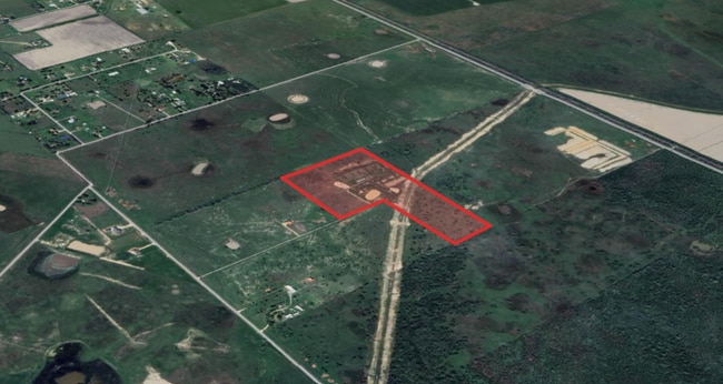
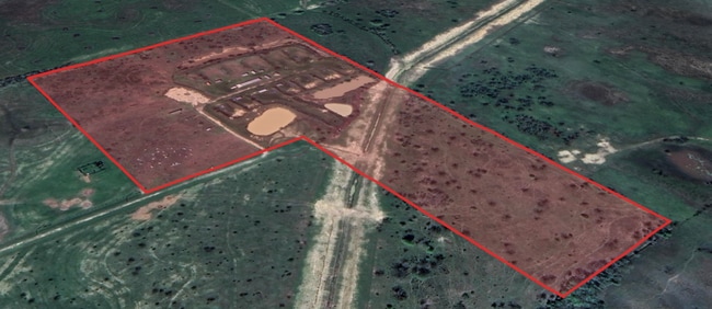
Property Record
Randon School Rd, Rosenberg, TX 77471

Save to a Folder
{{folder.Name}}
{{folder.ListingIds.length}} Properties
{{folder.ListingIds.length}} Property
Create a New Folder
Property Detail
Randon School Rd
0125-00-030-0030-901
0125 BBB AND C RY, BLOCK 30 (PT), ACRES 29.44
Commercialnec
FORT BEND
RQS
Texas
A Areas with a 1% annual chance of flooding and a 26% chance of flooding over the life of a 30-year mortgage.
29.44 AC
2025
Southwest Outlier
2025
Houston
675300
Houston-Pasadena-The Woodlands, TX
NEARBY LISTINGS FOR SALE OR LEASE
DEMOGRAPHICS near Randon School Rd
1 mile
3 mile
5 mile
2025 Total Population
117
2,324
4,803
2030 Population
135
2,685
5,532
Pop Growth 2025-2030
+ 15.38%
+ 15.53%
+ 15.18%
Average Age
37
38
39
2025 Total Households
37
758
1,593
HH Growth 2025-2030
+ 16.22%
+ 15.96%
+ 15.57%
Median Household Inc
$71,999
$60,855
$63,351
Avg Household Size
3.20
3.10
3.00
2025 Avg HH Vehicles
2.00
2.00
2.00
Median Home Value
$350,000
$409,322
$417,208
Median Year Built
1987
1987
1988
Nearby Places
Map Layers
Map Styles
 Street
 Aerial
Layers
 Traffic
 Biking
Places
Listings with unknown addresses are not visible on the map
- Restaurants
- Banks
- Shops
- Fitness
- Groceries
SALE & LEASE HISTORY
LISTING DATE
SALE/LEASE

Nov 20, 2024
For Sale
Nearby Properties
Address
Land Use
TOTAL SIZE
Lot Size
Zoning
Address
Land Use
TOTAL SIZE
Lot Size
Zoning
9.51 AC
Address
Land Use
TOTAL SIZE
Lot Size
Zoning
105,350 SF
11.50 AC
R
Address
Land Use
TOTAL SIZE
Lot Size
Zoning
51,250 SF
10.01 AC
S
Address
Land Use
TOTAL SIZE
Lot Size
Zoning
2,064 SF
93.87 AC
QO
Address
Land Use
TOTAL SIZE
Lot Size
Zoning
Address
Land Use
TOTAL SIZE
Lot Size
Zoning
8,135 SF
0.75 AC
Address
Land Use
TOTAL SIZE
Lot Size
Zoning
72.55 AC
Address
Land Use
TOTAL SIZE
Lot Size
Zoning
800 SF
89.75 AC
OTS
Address
Land Use
TOTAL SIZE
Lot Size
Zoning
78 AC
SO
Address
Land Use
TOTAL SIZE
Lot Size
Zoning
85.37 AC
Y
Address
Land Use
TOTAL SIZE
Lot Size
Zoning
11.50 AC
Address
Land Use
TOTAL SIZE
Lot Size
Zoning
21,190 SF
10 AC
ST
Address
Land Use
TOTAL SIZE
Lot Size
Zoning
2,910 SF
1 AC
Address
Land Use
TOTAL SIZE
Lot Size
Zoning
68.80 AC
Address
Land Use
TOTAL SIZE
Lot Size
Zoning
65.97 AC
QY
Address
Land Use
TOTAL SIZE
Lot Size
Zoning
Address
Land Use
TOTAL SIZE
Lot Size
Zoning
99.90 AC
Address
Land Use
TOTAL SIZE
Lot Size
Zoning
9.85 AC
S
Address
Land Use
TOTAL SIZE
Lot Size
Zoning
16.35 AC
Address
Land Use
TOTAL SIZE
Lot Size
Zoning
36.56 AC
SL
Address
Land Use
TOTAL SIZE
Lot Size
Zoning
15.79 AC
Address
Land Use
TOTAL SIZE
Lot Size
Zoning
789 SF
46.19 AC
Address
Land Use
TOTAL SIZE
Lot Size
Zoning
92.45 AC
SY
Address
Land Use
TOTAL SIZE
Lot Size
Zoning
101.43 AC
OY
Address
Land Use
TOTAL SIZE
Lot Size
Zoning
29 AC
S
Address
Land Use
TOTAL SIZE
Lot Size
Zoning
1,216 SF
5 AC
S
Address
Land Use
TOTAL SIZE
Lot Size
Zoning
57.27 AC
QS
Address
Land Use
TOTAL SIZE
Lot Size
Zoning
864 SF
79.50 AC
YO
Address
Land Use
TOTAL SIZE
Lot Size
Zoning
28,800 SF
2.65 AC
Address
Land Use
TOTAL SIZE
Lot Size
Zoning
33.29 AC
The World's #1 Commercial Real Estate Marketplace
Connect with us
© 2026 CoStar Group
The information above has been obtained from sources believed reliable. While we do not doubt its accuracy we have not verified it and make no guarantee, warranty or representation about it. It is your responsibility to independently confirm its accuracy and completeness. Any projections, opinions, assumptions, or estimates used are for example only and do not represent the current or future performance of the property. The value of this transaction to you depends on tax and other factors which should be evaluated by your tax, financial, and legal advisors. You and your advisors should conduct a careful, independent investigation of the property to determine to your satisfaction the suitability of the property for your needs.