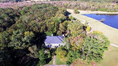
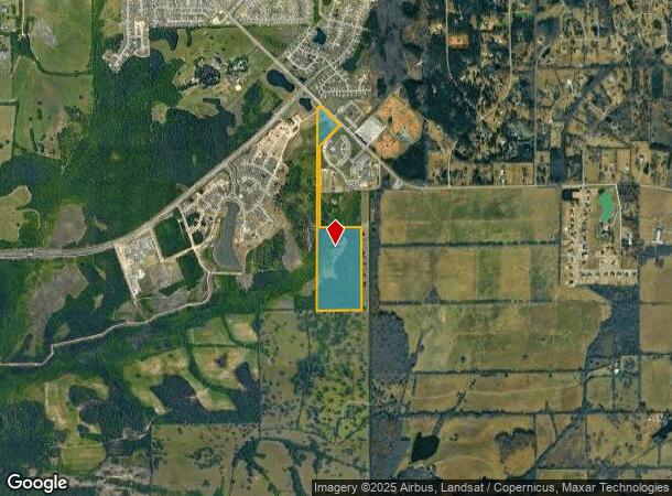
Property Record
Ray Thorington Rd Sw, Montgomery, AL 36117
NEARBY LISTINGS FOR SALE OR LEASE
Property Detail
Ray Thorington Rd Sw
16-01-02-0-000-023.000
SEC 2 T15N R19E 58.7 AC IN SW1/4 OF SW1/4 1601020000023000
Commercialacreage
Montgomery
X
Alabama
01101C0242J
58.70 AC
2025
North Montgomery
2025
Montgomery
005407
Montgomery, AL
DEMOGRAPHICS near Ray Thorington Rd Sw
1 Mile
3 Mile
5 Mile
2024 Total Population
1,356
13,952
42,266
2029 Population
1,338
13,491
40,875
Pop Growth 2024-2029
(1.33%)
(3.30%)
(3.29%)
Average Age
35
38
39
2024 Total Households
450
5,205
17,117
HH Growth 2024-2029
(1.33%)
(3.55%)
(3.51%)
Median Household Inc
$103,026
$108,138
$85,668
Avg Household Size
3.00
2.70
2.40
2024 Avg HH Vehicles
2.00
2.00
2.00
Median Home Value
$331,656
$335,447
$262,490
Median Year Built
2008
2004
1999
Nearby Places
Map Layers
Map Styles
 Street
 Aerial
- Restaurants
- Banks
- Shops
- Fitness
- Groceries
PUBLIC TRANSPORTATION
AIRPORT
Montgomery Regional (Dannelly Field)
DRIVE
WALK
Distance
Montgomery Regional (Dannelly Field)
29 min
18.4 mi
Freight Ports
Port of Panama City
DRIVE
WALK
Distance
Port of Panama City
237 min
185.6 mi
SALE & LEASE HISTORY
LISTING DATE
SALE/LEASE

Dec 08, 2017
For Sale
Nearby Properties
Address
Land Use
TOTAL SIZE
Lot Size
Zoning
Address
Land Use
TOTAL SIZE
Lot Size
Zoning
47,292 SF
63.99 AC
Address
Land Use
TOTAL SIZE
Lot Size
Zoning
57,408 SF
24.61 AC
Address
Land Use
TOTAL SIZE
Lot Size
Zoning
123,098 SF
60.33 AC
AGR-1
Address
Land Use
TOTAL SIZE
Lot Size
Zoning
44,082 SF
5.95 AC
Address
Land Use
TOTAL SIZE
Lot Size
Zoning
23,923 SF
19.61 AC
AGR-1
Address
Land Use
TOTAL SIZE
Lot Size
Zoning
84,279 SF
14.27 AC
Address
Land Use
TOTAL SIZE
Lot Size
Zoning
25.72 AC
Address
Land Use
TOTAL SIZE
Lot Size
Zoning
61,857 SF
6.93 AC
B-2-Q
Address
Land Use
TOTAL SIZE
Lot Size
Zoning
28,235 SF
25.53 AC
Address
Land Use
TOTAL SIZE
Lot Size
Zoning
43,139 SF
0.72 AC
T5
Address
Land Use
TOTAL SIZE
Lot Size
Zoning
15,319 SF
16.10 AC
B-3
Address
Land Use
TOTAL SIZE
Lot Size
Zoning
206.60 AC
PUD
Address
Land Use
TOTAL SIZE
Lot Size
Zoning
25,813 SF
14.70 AC
Address
Land Use
TOTAL SIZE
Lot Size
Zoning
60,419 SF
4.30 AC
B-2-Q
Address
Land Use
TOTAL SIZE
Lot Size
Zoning
20,595 SF
17.67 AC
PUD
Address
Land Use
TOTAL SIZE
Lot Size
Zoning
105.66 AC
Address
Land Use
TOTAL SIZE
Lot Size
Zoning
26,433 SF
7.30 AC
PUD
Address
Land Use
TOTAL SIZE
Lot Size
Zoning
18,080 SF
0.51 AC
Address
Land Use
TOTAL SIZE
Lot Size
Zoning
140.80 AC
PUD
Address
Land Use
TOTAL SIZE
Lot Size
Zoning
160.40 AC
PUD
Address
Land Use
TOTAL SIZE
Lot Size
Zoning
8.80 AC
PUD
Address
Land Use
TOTAL SIZE
Lot Size
Zoning
3,263 SF
56.80 AC
AGR-1
Address
Land Use
TOTAL SIZE
Lot Size
Zoning
11,252 SF
1.81 AC
B-3
Address
Land Use
TOTAL SIZE
Lot Size
Zoning
56 AC
INST
Address
Land Use
TOTAL SIZE
Lot Size
Zoning
12,255 SF
4.92 AC
PGH-40
Address
Land Use
TOTAL SIZE
Lot Size
Zoning
34.80 AC
Address
Land Use
TOTAL SIZE
Lot Size
Zoning
235.30 AC
PUD
Address
Land Use
TOTAL SIZE
Lot Size
Zoning
8,876 SF
3.60 AC
Address
Land Use
TOTAL SIZE
Lot Size
Zoning
6,400 SF
233 AC
The World's #1 Commercial Real Estate Marketplace
Connect with us
© 2025 CoStar Group
The information above has been obtained from sources believed reliable. While we do not doubt its accuracy we have not verified it and make no guarantee, warranty or representation about it. It is your responsibility to independently confirm its accuracy and completeness. Any projections, opinions, assumptions, or estimates used are for example only and do not represent the current or future performance of the property. The value of this transaction to you depends on tax and other factors which should be evaluated by your tax, financial, and legal advisors. You and your advisors should conduct a careful, independent investigation of the property to determine to your satisfaction the suitability of the property for your needs.