Property Record
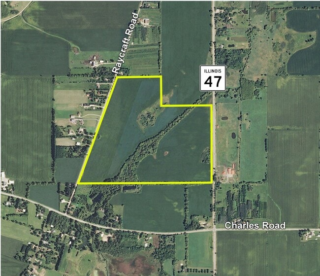
Raycraft Rd, Woodstock, IL 60098
Property Detail
Raycraft Rd
Chicago-Naperville-Elgin, IL-IN
DOC 2021R0024628 E1/2 NE1/4 LYING E OF CEN RAYCRAFT RD
08-20-100-007
MCHENRY
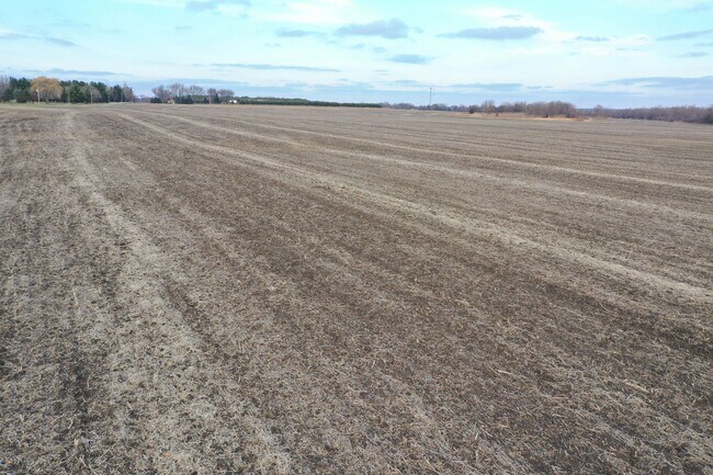
Farms
Illinois
AE The base floodplain where base flood elevations are provided. AE Zones are now used on new format FIRMs instead of A1-A30 Zones.
137.47 AC
2024
Far Northwest
2024
Chicago
870903
NEARBY LISTINGS FOR SALE OR LEASE
-
-
View all Woodstock listings for sale on LoopNet.com
DEMOGRAPHICS near Raycraft Rd
1 mile
3 mile
5 mile
2025 Total Population
5,583
27,824
33,891
2030 Population
5,648
28,270
34,421
Pop Growth 2025-2030
+ 1.16%
+ 1.60%
+ 1.56%
Average Age
40
40
41
2025 Total Households
2,325
10,610
12,770
HH Growth 2025-2030
+ 1.12%
+ 1.63%
+ 1.59%
Median Household Inc
$65,686
$83,012
$88,461
Avg Household Size
2.30
2.50
2.50
2025 Avg HH Vehicles
2.00
2.00
2.00
Median Home Value
$272,291
$267,583
$284,588
Median Year Built
1985
1983
1984
Nearby Places
Map Layers
Map Styles
 Street
 Aerial
Layers
 Traffic
 Biking
Places
Listings with unknown addresses are not visible on the map
- Restaurants
- Banks
- Shops
- Fitness
- Groceries
PUBLIC TRANSPORTATION
COMMUTER RAIL
Woodstock Station (Union Pacific Northwest Line - Northeast Illinois Regional Commuter Railroad (Metra))
Drive
Walk
Distance
Woodstock Station (Union Pacific Northwest Line - Northeast Illinois Regional Commuter Railroad (Metra))
10 min
4.4 mi
Freight Ports
Port Milwaukee
Drive
Walk
Distance
Port Milwaukee
89 min
64.1 mi
SALE & LEASE HISTORY
LISTING DATE
SALE/LEASE

Dec 11, 2020
For Sale
Nearby Properties
Address
Land Use
TOTAL SIZE
Lot Size
Zoning
Address
Land Use
TOTAL SIZE
Lot Size
Zoning
45,876 SF
5.02 AC
Address
Land Use
TOTAL SIZE
Lot Size
Zoning
2.78 AC
Address
Land Use
TOTAL SIZE
Lot Size
Zoning
Address
Land Use
TOTAL SIZE
Lot Size
Zoning
Address
Land Use
TOTAL SIZE
Lot Size
Zoning
22,724 SF
3.63 AC
Address
Land Use
TOTAL SIZE
Lot Size
Zoning
139,352 SF
29.32 AC
Address
Land Use
TOTAL SIZE
Lot Size
Zoning
Address
Land Use
TOTAL SIZE
Lot Size
Zoning
35,389 SF
4.44 AC
Address
Land Use
TOTAL SIZE
Lot Size
Zoning
Address
Land Use
TOTAL SIZE
Lot Size
Zoning
Address
Land Use
TOTAL SIZE
Lot Size
Zoning
9,785 SF
2.58 AC
Address
Land Use
TOTAL SIZE
Lot Size
Zoning
Address
Land Use
TOTAL SIZE
Lot Size
Zoning
27,360 SF
3.62 AC
Address
Land Use
TOTAL SIZE
Lot Size
Zoning
Address
Land Use
TOTAL SIZE
Lot Size
Zoning
4,950 SF
0.52 AC
Address
Land Use
TOTAL SIZE
Lot Size
Zoning
23,864 SF
1.40 AC
Address
Land Use
TOTAL SIZE
Lot Size
Zoning
Address
Land Use
TOTAL SIZE
Lot Size
Zoning
7,200 SF
1.03 AC
Address
Land Use
TOTAL SIZE
Lot Size
Zoning
12.41 AC
Address
Land Use
TOTAL SIZE
Lot Size
Zoning
19,884 SF
3.29 AC
Address
Land Use
TOTAL SIZE
Lot Size
Zoning
23,520 SF
2 AC
Address
Land Use
TOTAL SIZE
Lot Size
Zoning
16,711 SF
6.97 AC
Address
Land Use
TOTAL SIZE
Lot Size
Zoning
22,000 SF
1.50 AC
Address
Land Use
TOTAL SIZE
Lot Size
Zoning
Address
Land Use
TOTAL SIZE
Lot Size
Zoning
0.20 AC
Address
Land Use
TOTAL SIZE
Lot Size
Zoning
Address
Land Use
TOTAL SIZE
Lot Size
Zoning
9,310 SF
0.69 AC
Address
Land Use
TOTAL SIZE
Lot Size
Zoning
16,480 SF
1.68 AC
Address
Land Use
TOTAL SIZE
Lot Size
Zoning
16,000 SF
5.35 AC
Address
Land Use
TOTAL SIZE
Lot Size
Zoning
9,600 SF
8.20 AC
The World's #1 Commercial Real Estate Marketplace
Connect with us
© 2026 CoStar Group
The information above has been obtained from sources believed reliable. While we do not doubt its accuracy we have not verified it and make no guarantee, warranty or representation about it. It is your responsibility to independently confirm its accuracy and completeness. Any projections, opinions, assumptions, or estimates used are for example only and do not represent the current or future performance of the property. The value of this transaction to you depends on tax and other factors which should be evaluated by your tax, financial, and legal advisors. You and your advisors should conduct a careful, independent investigation of the property to determine to your satisfaction the suitability of the property for your needs.