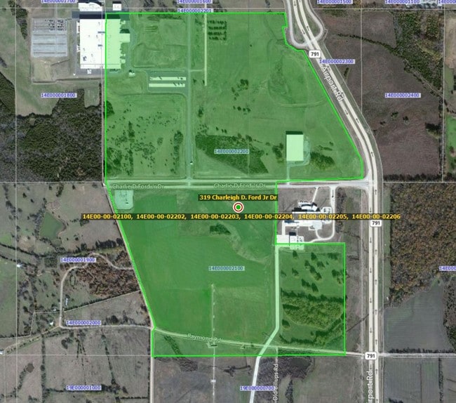
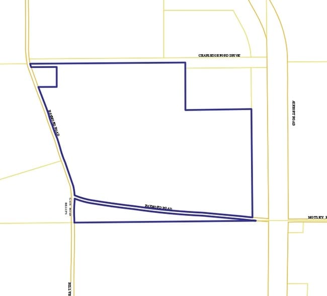
Property Record
Raymond Rd, Columbus, MS 39701
Save to a Folder
{{folder.Name}}
{{folder.ListingIds.length}} Properties
{{folder.ListingIds.length}} Property
Create a New Folder
Property Detail
Raymond Rd
Columbus, MS
PT NE4 AIRPORT RD
14E00-00-02100
LOWNDES
Airport
Mississippi
B and X Area of moderate flood hazard, usually the area between the limits of the 100-year and 500-year floods.
169.98 AC
2025
Vicksburg/Central Area
2025
Other Market Areas
001000
NEARBY LISTINGS FOR SALE OR LEASE
-
-
View all Columbus listings for sale on LoopNet.com
DEMOGRAPHICS near Raymond Rd
1 mile
3 mile
5 mile
2025 Total Population
5
606
1,569
2030 Population
5
579
1,517
Pop Growth 2025-2030
0.00%
(4.46%)
(3.31%)
Average Age
0
46
46
2025 Total Households
2
268
695
HH Growth 2025-2030
0.00%
(4.10%)
(3.31%)
Median Household Inc
$0
$59,999
$57,926
Avg Household Size
1.50
2.20
2.20
2025 Avg HH Vehicles
2.00
2.00
2.00
Median Home Value
$0
$289,473
$262,831
Median Year Built
2005
1986
1990
Nearby Places
Map Layers
Map Styles
 Street
 Aerial
Layers
 Traffic
 Biking
Places
Listings with unknown addresses are not visible on the map
- Restaurants
- Banks
- Shops
- Fitness
- Groceries
PUBLIC TRANSPORTATION
AIRPORT
Golden Triangle Regional
Drive
Walk
Distance
Golden Triangle Regional
9 min
2.5 mi
Freight Ports
Port of Mobile
Drive
Walk
Distance
Port of Mobile
262 min
224.3 mi
Nearby Properties
Address
Land Use
TOTAL SIZE
Lot Size
Zoning
Address
Land Use
TOTAL SIZE
Lot Size
Zoning
1,259.74 AC
Address
Land Use
TOTAL SIZE
Lot Size
Zoning
0.16 AC
Address
Land Use
TOTAL SIZE
Lot Size
Zoning
122,288 SF
0.36 AC
Address
Land Use
TOTAL SIZE
Lot Size
Zoning
14,255 SF
17.20 AC
Address
Land Use
TOTAL SIZE
Lot Size
Zoning
323.20 AC
Address
Land Use
TOTAL SIZE
Lot Size
Zoning
32.20 AC
Address
Land Use
TOTAL SIZE
Lot Size
Zoning
Address
Land Use
TOTAL SIZE
Lot Size
Zoning
Address
Land Use
TOTAL SIZE
Lot Size
Zoning
0.17 AC
Address
Land Use
TOTAL SIZE
Lot Size
Zoning
10,387 SF
0.36 AC
Address
Land Use
TOTAL SIZE
Lot Size
Zoning
Address
Land Use
TOTAL SIZE
Lot Size
Zoning
231.10 AC
Address
Land Use
TOTAL SIZE
Lot Size
Zoning
227.50 AC
Address
Land Use
TOTAL SIZE
Lot Size
Zoning
250,000 SF
23.40 AC
Address
Land Use
TOTAL SIZE
Lot Size
Zoning
0.17 AC
Address
Land Use
TOTAL SIZE
Lot Size
Zoning
19.10 AC
Address
Land Use
TOTAL SIZE
Lot Size
Zoning
Address
Land Use
TOTAL SIZE
Lot Size
Zoning
61,650 SF
0.36 AC
Address
Land Use
TOTAL SIZE
Lot Size
Zoning
Address
Land Use
TOTAL SIZE
Lot Size
Zoning
32,666 SF
0.36 AC
Address
Land Use
TOTAL SIZE
Lot Size
Zoning
0.16 AC
Address
Land Use
TOTAL SIZE
Lot Size
Zoning
10.36 AC
Address
Land Use
TOTAL SIZE
Lot Size
Zoning
2,128 SF
0.36 AC
Address
Land Use
TOTAL SIZE
Lot Size
Zoning
Address
Land Use
TOTAL SIZE
Lot Size
Zoning
11,890 SF
10.80 AC
Address
Land Use
TOTAL SIZE
Lot Size
Zoning
34.90 AC
Address
Land Use
TOTAL SIZE
Lot Size
Zoning
23,984 SF
14 AC
Address
Land Use
TOTAL SIZE
Lot Size
Zoning
172.70 AC
Address
Land Use
TOTAL SIZE
Lot Size
Zoning
57,600 SF
15 AC
Address
Land Use
TOTAL SIZE
Lot Size
Zoning
163.80 AC
The World's #1 Commercial Real Estate Marketplace
Connect with us
© 2026 CoStar Group
The information above has been obtained from sources believed reliable. While we do not doubt its accuracy we have not verified it and make no guarantee, warranty or representation about it. It is your responsibility to independently confirm its accuracy and completeness. Any projections, opinions, assumptions, or estimates used are for example only and do not represent the current or future performance of the property. The value of this transaction to you depends on tax and other factors which should be evaluated by your tax, financial, and legal advisors. You and your advisors should conduct a careful, independent investigation of the property to determine to your satisfaction the suitability of the property for your needs.