Property Record
Red Fir Ct, Tehachapi, CA 93561
Property Detail
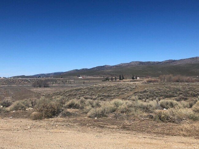
Red Fir Ct
Bakersfield-Delano, CA
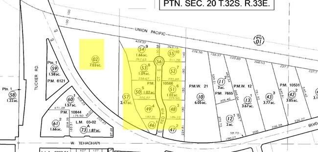
PARCEL MAP 10566 , LOT 5
415-130-50-00-7
KERN
Industrialacreage
California
A Areas with a 1% annual chance of flooding and a 26% chance of flooding over the life of a 30-year mortgage.
5
2024
1.02 AC
2025
SE Outlying Kern County
006101
Bakersfield
NEARBY LISTINGS FOR SALE OR LEASE
DEMOGRAPHICS near Red Fir Ct
1 mile
3 mile
5 mile
2025 Total Population
4,288
21,332
23,496
2030 Population
4,411
22,065
24,311
Pop Growth 2025-2030
+ 2.87%
+ 3.44%
+ 3.47%
Average Age
38
39
40
2025 Total Households
1,639
8,063
8,917
HH Growth 2025-2030
+ 2.75%
+ 3.39%
+ 3.43%
Median Household Inc
$59,791
$81,556
$83,936
Avg Household Size
2.60
2.60
2.60
2025 Avg HH Vehicles
2.00
2.00
2.00
Median Home Value
$371,738
$390,753
$392,324
Median Year Built
1973
1986
1987
Nearby Places
Map Layers
Map Styles
 Street
 Aerial
Transit
 Traffic
 Biking
Places
Listings with unknown addresses are not visible on the map
- Restaurants
- Banks
- Shops
- Fitness
- Groceries
SALE & LEASE HISTORY
LISTING DATE
SALE/LEASE

Dec 19, 2022
For Sale
Nearby Properties
Address
Land Use
TOTAL SIZE
Lot Size
Zoning
Address
Land Use
TOTAL SIZE
Lot Size
Zoning
157,779 SF
20.17 AC
C-3
Address
Land Use
TOTAL SIZE
Lot Size
Zoning
131,650 SF
26.91 AC
M-2
Address
Land Use
TOTAL SIZE
Lot Size
Zoning
1.93 AC
C-3
Address
Land Use
TOTAL SIZE
Lot Size
Zoning
43,147 SF
2.41 AC
C3
Address
Land Use
TOTAL SIZE
Lot Size
Zoning
34,884 SF
2.77 AC
C2
Address
Land Use
TOTAL SIZE
Lot Size
Zoning
6.20 AC
M1
Address
Land Use
TOTAL SIZE
Lot Size
Zoning
104,212 SF
11.55 AC
M2
Address
Land Use
TOTAL SIZE
Lot Size
Zoning
14,704 SF
10.43 AC
M-1
Address
Land Use
TOTAL SIZE
Lot Size
Zoning
49,500 SF
3.06 AC
C2
Address
Land Use
TOTAL SIZE
Lot Size
Zoning
Address
Land Use
TOTAL SIZE
Lot Size
Zoning
55,638 SF
2.79 AC
Address
Land Use
TOTAL SIZE
Lot Size
Zoning
49,500 SF
3.06 AC
C2
Address
Land Use
TOTAL SIZE
Lot Size
Zoning
54,528 SF
4.80 AC
R-2
Address
Land Use
TOTAL SIZE
Lot Size
Zoning
14,488 SF
1.66 AC
C-3
Address
Land Use
TOTAL SIZE
Lot Size
Zoning
7.01 AC
M-1 PD
Address
Land Use
TOTAL SIZE
Lot Size
Zoning
3,072 SF
4.83 AC
Address
Land Use
TOTAL SIZE
Lot Size
Zoning
20,878 SF
2.44 AC
C3
Address
Land Use
TOTAL SIZE
Lot Size
Zoning
19,500 SF
2.75 AC
M-1
Address
Land Use
TOTAL SIZE
Lot Size
Zoning
57,846 SF
3.33 AC
C3
Address
Land Use
TOTAL SIZE
Lot Size
Zoning
14,488 SF
1.66 AC
C-3
Address
Land Use
TOTAL SIZE
Lot Size
Zoning
45,873 SF
4.98 AC
Address
Land Use
TOTAL SIZE
Lot Size
Zoning
33,259 SF
1.57 AC
C-3
Address
Land Use
TOTAL SIZE
Lot Size
Zoning
968 SF
17.27 AC
M-2
Address
Land Use
TOTAL SIZE
Lot Size
Zoning
29,700 SF
3.61 AC
R-2
Address
Land Use
TOTAL SIZE
Lot Size
Zoning
54,490 SF
4.02 AC
Address
Land Use
TOTAL SIZE
Lot Size
Zoning
11,045 SF
1.88 AC
C2
Address
Land Use
TOTAL SIZE
Lot Size
Zoning
4,030 SF
6.05 AC
M1
Address
Land Use
TOTAL SIZE
Lot Size
Zoning
9,025 SF
4.78 AC
A-1
Address
Land Use
TOTAL SIZE
Lot Size
Zoning
2,370 SF
0.63 AC
C2
Address
Land Use
TOTAL SIZE
Lot Size
Zoning
29,045 SF
5.01 AC
The World's #1 Commercial Real Estate Marketplace
Connect with us
© 2026 CoStar Group
The information above has been obtained from sources believed reliable. While we do not doubt its accuracy we have not verified it and make no guarantee, warranty or representation about it. It is your responsibility to independently confirm its accuracy and completeness. Any projections, opinions, assumptions, or estimates used are for example only and do not represent the current or future performance of the property. The value of this transaction to you depends on tax and other factors which should be evaluated by your tax, financial, and legal advisors. You and your advisors should conduct a careful, independent investigation of the property to determine to your satisfaction the suitability of the property for your needs.