Property Record
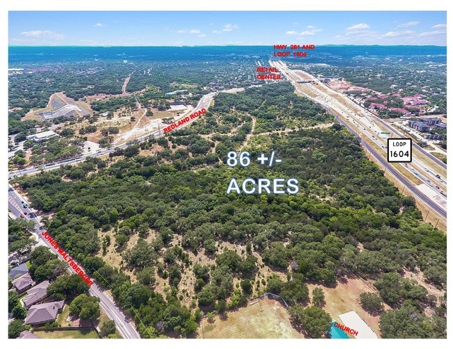
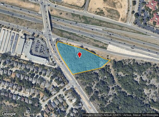
Redland Rd, San Antonio, TX 78247
NEARBY LISTINGS FOR SALE OR LEASE
Property Detail
Redland Rd
San Antonio-New Braunfels, TX
Conv A/S Code
17725-020-0010
NCB 17725 BLK 20 LOT NW 44.80 FT OF 1 (FISCHER 4.0 ACRES) 2016 MAP/LEGAL DESC UPDATE PER DEED 17136/296 EXE 3-5-15 FILED 3-18-15; PLAT 9574/211 FILED 4-5-07 FOR 2008
Privatepreserveopenspacevacantlandforestlandconservation
Bexar
A
Texas
48029C0255G
1
2024
3.60 AC
2025
North Central
121110
San Antonio
DEMOGRAPHICS near Redland Rd
1 Mile
3 Mile
5 Mile
2024 Total Population
9,517
81,295
224,269
2029 Population
10,111
86,277
238,126
Pop Growth 2024-2029
+ 6.24%
+ 6.13%
+ 6.18%
Average Age
39
40
39
2024 Total Households
3,976
32,753
87,812
HH Growth 2024-2029
+ 6.34%
+ 6.31%
+ 6.37%
Median Household Inc
$75,516
$85,095
$81,682
Avg Household Size
2.30
2.40
2.50
2024 Avg HH Vehicles
2.00
2.00
2.00
Median Home Value
$295,045
$270,946
$278,328
Median Year Built
1992
1993
1994
Nearby Places
Map Layers
Map Styles
 Street
 Aerial
- Restaurants
- Banks
- Shops
- Fitness
- Groceries
PUBLIC TRANSPORTATION
AIRPORT
San Antonio International
DRIVE
WALK
Distance
San Antonio International
16 min
11.3 mi
Freight Ports
Calhoun Port
DRIVE
WALK
Distance
Calhoun Port
183 min
153.8 mi
SALE & LEASE HISTORY
LISTING DATE
SALE/LEASE

Jul 11, 2018
For Sale
Nearby Properties
Address
Land Use
TOTAL SIZE
Lot Size
Zoning
Address
Land Use
TOTAL SIZE
Lot Size
Zoning
621,591 SF
15.25 AC
Address
Land Use
TOTAL SIZE
Lot Size
Zoning
427,456 SF
37.12 AC
Address
Land Use
TOTAL SIZE
Lot Size
Zoning
435,882 SF
27.85 AC
Address
Land Use
TOTAL SIZE
Lot Size
Zoning
311,728 SF
7.47 AC
Address
Land Use
TOTAL SIZE
Lot Size
Zoning
383,541 SF
12.41 AC
Address
Land Use
TOTAL SIZE
Lot Size
Zoning
298,710 SF
11.36 AC
Address
Land Use
TOTAL SIZE
Lot Size
Zoning
292,126 SF
12.86 AC
Address
Land Use
TOTAL SIZE
Lot Size
Zoning
307,210 SF
14.26 AC
Address
Land Use
TOTAL SIZE
Lot Size
Zoning
315,719 SF
13.91 AC
Address
Land Use
TOTAL SIZE
Lot Size
Zoning
280,330 SF
20.99 AC
Address
Land Use
TOTAL SIZE
Lot Size
Zoning
441,676 SF
19.99 AC
Address
Land Use
TOTAL SIZE
Lot Size
Zoning
306,523 SF
16.29 AC
Address
Land Use
TOTAL SIZE
Lot Size
Zoning
209,715 SF
22.91 AC
Address
Land Use
TOTAL SIZE
Lot Size
Zoning
317,041 SF
26.69 AC
Address
Land Use
TOTAL SIZE
Lot Size
Zoning
290,188 SF
14.60 AC
Address
Land Use
TOTAL SIZE
Lot Size
Zoning
269,525 SF
17.75 AC
Address
Land Use
TOTAL SIZE
Lot Size
Zoning
341,841 SF
22 AC
Address
Land Use
TOTAL SIZE
Lot Size
Zoning
249,562 SF
9.65 AC
Address
Land Use
TOTAL SIZE
Lot Size
Zoning
340,570 SF
19.15 AC
Address
Land Use
TOTAL SIZE
Lot Size
Zoning
907.40 AC
Address
Land Use
TOTAL SIZE
Lot Size
Zoning
240,644 SF
16.35 AC
Address
Land Use
TOTAL SIZE
Lot Size
Zoning
281,805 SF
14.52 AC
Address
Land Use
TOTAL SIZE
Lot Size
Zoning
297,882 SF
17.16 AC
Address
Land Use
TOTAL SIZE
Lot Size
Zoning
256,048 SF
15.45 AC
Address
Land Use
TOTAL SIZE
Lot Size
Zoning
158,818 SF
4.33 AC
Address
Land Use
TOTAL SIZE
Lot Size
Zoning
146,700 SF
56.18 AC
Address
Land Use
TOTAL SIZE
Lot Size
Zoning
257,288 SF
10.57 AC
Address
Land Use
TOTAL SIZE
Lot Size
Zoning
256,497 SF
16.53 AC
Address
Land Use
TOTAL SIZE
Lot Size
Zoning
108,380 SF
18.58 AC
Address
Land Use
TOTAL SIZE
Lot Size
Zoning
148,944 SF
29.35 AC
The World's #1 Commercial Real Estate Marketplace
Connect with us
© 2026 CoStar Group
The information above has been obtained from sources believed reliable. While we do not doubt its accuracy we have not verified it and make no guarantee, warranty or representation about it. It is your responsibility to independently confirm its accuracy and completeness. Any projections, opinions, assumptions, or estimates used are for example only and do not represent the current or future performance of the property. The value of this transaction to you depends on tax and other factors which should be evaluated by your tax, financial, and legal advisors. You and your advisors should conduct a careful, independent investigation of the property to determine to your satisfaction the suitability of the property for your needs.