Property Record
Reeh Rd, Needville, TX 77461
Property Detail
Reeh Rd
0281-00-000-0500-906
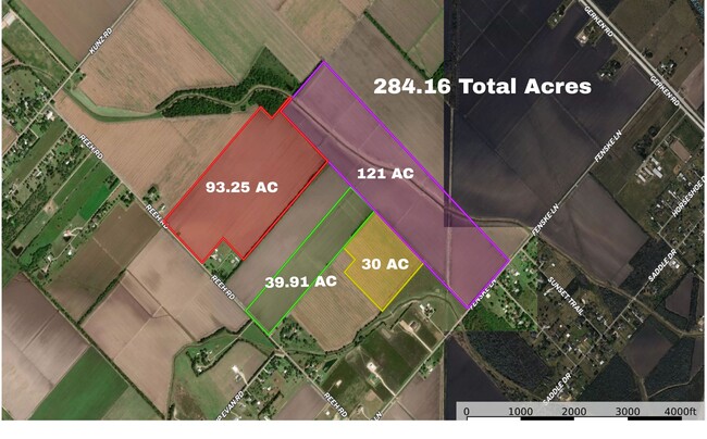
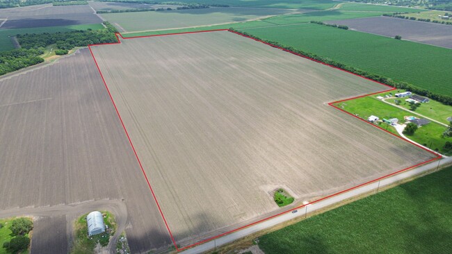
0281 WM LEECH, ACRES 72.7643, (PART OF A 93.25 ACRE TRACT)
Farms
FORT BEND
TS
Texas
B and X Area of moderate flood hazard, usually the area between the limits of the 100-year and 500-year floods.
39.99 AC
2024
Southwest Outlier
2025
Houston
675600
Houston-Pasadena-The Woodlands, TX
NEARBY LISTINGS FOR SALE OR LEASE
DEMOGRAPHICS near Reeh Rd
1 mile
3 mile
5 mile
2024 Total Population
261
10,139
29,774
2029 Population
354
13,782
40,544
Pop Growth 2024-2029
+ 35.63%
+ 35.93%
+ 36.17%
Average Age
41
37
36
2024 Total Households
86
3,131
9,477
HH Growth 2024-2029
+ 37.21%
+ 36.89%
+ 37.13%
Median Household Inc
$81,250
$80,647
$78,404
Avg Household Size
3.00
3.20
3.10
2024 Avg HH Vehicles
2.00
2.00
2.00
Median Home Value
$571,428
$322,016
$278,803
Median Year Built
1990
2008
2006
Nearby Places
Map Layers
Map Styles
 Street
 Aerial
Transit
 Traffic
 Biking
Places
Listings with unknown addresses are not visible on the map
- Restaurants
- Banks
- Shops
- Fitness
- Groceries
SALE & LEASE HISTORY
LISTING DATE
SALE/LEASE

May 30, 2025
For Sale
Nearby Properties
Address
Land Use
TOTAL SIZE
Lot Size
Zoning
Address
Land Use
TOTAL SIZE
Lot Size
Zoning
146.35 AC
ST
Address
Land Use
TOTAL SIZE
Lot Size
Zoning
672 SF
230.34 AC
YT
Address
Land Use
TOTAL SIZE
Lot Size
Zoning
Address
Land Use
TOTAL SIZE
Lot Size
Zoning
208.52 AC
OST
Address
Land Use
TOTAL SIZE
Lot Size
Zoning
30.46 AC
S
Address
Land Use
TOTAL SIZE
Lot Size
Zoning
109.89 AC
YQ
Address
Land Use
TOTAL SIZE
Lot Size
Zoning
111.59 AC
QOY
Address
Land Use
TOTAL SIZE
Lot Size
Zoning
864 SF
80.11 AC
QYSN
Address
Land Use
TOTAL SIZE
Lot Size
Zoning
50,000 SF
13 AC
Address
Land Use
TOTAL SIZE
Lot Size
Zoning
15.19 AC
Address
Land Use
TOTAL SIZE
Lot Size
Zoning
45.10 AC
STR
Address
Land Use
TOTAL SIZE
Lot Size
Zoning
1,076 SF
80.30 AC
QY
Address
Land Use
TOTAL SIZE
Lot Size
Zoning
57.02 AC
Address
Land Use
TOTAL SIZE
Lot Size
Zoning
93.42 AC
Address
Land Use
TOTAL SIZE
Lot Size
Zoning
14.81 AC
OS
Address
Land Use
TOTAL SIZE
Lot Size
Zoning
3.90 AC
Address
Land Use
TOTAL SIZE
Lot Size
Zoning
29 AC
SQT
Address
Land Use
TOTAL SIZE
Lot Size
Zoning
1,600 SF
16.39 AC
OS
Address
Land Use
TOTAL SIZE
Lot Size
Zoning
1.42 AC
Address
Land Use
TOTAL SIZE
Lot Size
Zoning
35 AC
S
Address
Land Use
TOTAL SIZE
Lot Size
Zoning
3,248 SF
89.86 AC
QOY
Address
Land Use
TOTAL SIZE
Lot Size
Zoning
15.50 AC
TY
Address
Land Use
TOTAL SIZE
Lot Size
Zoning
6.48 AC
S
Address
Land Use
TOTAL SIZE
Lot Size
Zoning
29,100 SF
2 AC
Address
Land Use
TOTAL SIZE
Lot Size
Zoning
11.54 AC
TS
Address
Land Use
TOTAL SIZE
Lot Size
Zoning
36,400 SF
2.47 AC
Address
Land Use
TOTAL SIZE
Lot Size
Zoning
11,030 SF
12.30 AC
Address
Land Use
TOTAL SIZE
Lot Size
Zoning
23.10 AC
Q
Address
Land Use
TOTAL SIZE
Lot Size
Zoning
Address
Land Use
TOTAL SIZE
Lot Size
Zoning
5,862 SF
26.57 AC
The World's #1 Commercial Real Estate Marketplace
Connect with us
© 2026 CoStar Group
The information above has been obtained from sources believed reliable. While we do not doubt its accuracy we have not verified it and make no guarantee, warranty or representation about it. It is your responsibility to independently confirm its accuracy and completeness. Any projections, opinions, assumptions, or estimates used are for example only and do not represent the current or future performance of the property. The value of this transaction to you depends on tax and other factors which should be evaluated by your tax, financial, and legal advisors. You and your advisors should conduct a careful, independent investigation of the property to determine to your satisfaction the suitability of the property for your needs.