Property Record
Remount Rd N, North Charleston, SC 29406
NEARBY LISTINGS FOR SALE OR LEASE
Property Detail
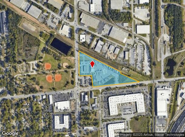
Remount Rd N
502-00-00-004
Property Of Mead Westvaco
Commercialnec
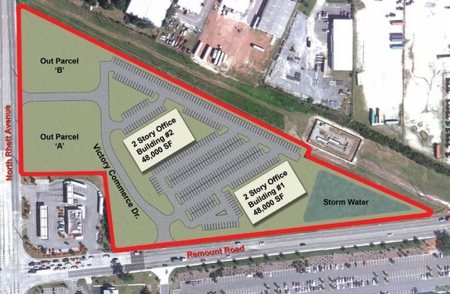
DESCRIPTION -PARCEL C1 DESCRIPTION -PARCEL C1 SITE NAME -N SIDE E SIDE N RHETT AVE
X
Charleston
45019C0315K
South Carolina
2025
10.34 AC
2024
North Charleston
003104
Charleston/N Charleston
9,691 SF
Charleston-North Charleston, SC
DEMOGRAPHICS near Remount Rd N
1 Mile
3 Mile
5 Mile
2024 Total Population
5,969
37,228
97,562
2029 Population
6,679
41,372
108,553
Pop Growth 2024-2029
+ 11.89%
+ 11.13%
+ 11.27%
Average Age
37
38
37
2024 Total Households
2,469
15,514
37,941
HH Growth 2024-2029
+ 11.79%
+ 10.86%
+ 11.19%
Median Household Inc
$52,101
$54,973
$53,840
Avg Household Size
2.30
2.30
2.40
2024 Avg HH Vehicles
1.00
2.00
2.00
Median Home Value
$212,558
$247,986
$236,275
Median Year Built
1974
1977
1983
Nearby Places
Map Layers
Map Styles
 Street
 Aerial
- Restaurants
- Banks
- Shops
- Fitness
- Groceries
PUBLIC TRANSPORTATION
COMMUTER RAIL
DRIVE
WALK
Distance
7 min
3.0 mi
AIRPORT
Charleston AFB/International
DRIVE
WALK
Distance
Charleston AFB/International
17 min
9.0 mi
Freight Ports
North Charleston Terminal
DRIVE
WALK
Distance
North Charleston Terminal
2 min
0.4 mi
Nearby Properties
Address
Land Use
TOTAL SIZE
Lot Size
Zoning
Address
Land Use
TOTAL SIZE
Lot Size
Zoning
6,848 SF
43.53 AC
CHARLESTON
Address
Land Use
TOTAL SIZE
Lot Size
Zoning
27,900 SF
102.67 AC
Address
Land Use
TOTAL SIZE
Lot Size
Zoning
202,154 SF
16.34 AC
Address
Land Use
TOTAL SIZE
Lot Size
Zoning
197,100 SF
34.14 AC
HANAHAN -
Address
Land Use
TOTAL SIZE
Lot Size
Zoning
64,584 SF
10.92 AC
HANAHAN -
Address
Land Use
TOTAL SIZE
Lot Size
Zoning
137,576 SF
5 AC
HANAHAN -
Address
Land Use
TOTAL SIZE
Lot Size
Zoning
68,655 SF
9.48 AC
Address
Land Use
TOTAL SIZE
Lot Size
Zoning
36,882 SF
5.80 AC
HANAHAN -
Address
Land Use
TOTAL SIZE
Lot Size
Zoning
105,666 SF
8.25 AC
Address
Land Use
TOTAL SIZE
Lot Size
Zoning
36,912 SF
6.19 AC
HANAHAN -
Address
Land Use
TOTAL SIZE
Lot Size
Zoning
21,364 SF
7.71 AC
Address
Land Use
TOTAL SIZE
Lot Size
Zoning
3,672 SF
3.62 AC
HANAHAN -
Address
Land Use
TOTAL SIZE
Lot Size
Zoning
10,560 SF
7.50 AC
Address
Land Use
TOTAL SIZE
Lot Size
Zoning
4,740 SF
12.17 AC
Address
Land Use
TOTAL SIZE
Lot Size
Zoning
68,208 SF
21.38 AC
HANAHAN -
Address
Land Use
TOTAL SIZE
Lot Size
Zoning
922.90 AC
HANAHAN -
Address
Land Use
TOTAL SIZE
Lot Size
Zoning
7,176 SF
3.55 AC
HANAHAN -
Address
Land Use
TOTAL SIZE
Lot Size
Zoning
77,990 SF
8.30 AC
Address
Land Use
TOTAL SIZE
Lot Size
Zoning
54,449 SF
10.56 AC
HANAHAN -
Address
Land Use
TOTAL SIZE
Lot Size
Zoning
48,885 SF
5.02 AC
Address
Land Use
TOTAL SIZE
Lot Size
Zoning
210,664 SF
8.87 AC
HANAHAN -
Address
Land Use
TOTAL SIZE
Lot Size
Zoning
14,775 SF
1.52 AC
HANAHAN -
Address
Land Use
TOTAL SIZE
Lot Size
Zoning
78,764 SF
4.15 AC
HANAHAN -
Address
Land Use
TOTAL SIZE
Lot Size
Zoning
1,303 SF
4.77 AC
Address
Land Use
TOTAL SIZE
Lot Size
Zoning
15,027 SF
3.62 AC
HANAHAN -
Address
Land Use
TOTAL SIZE
Lot Size
Zoning
175,800 SF
7.30 AC
HANAHAN -
Address
Land Use
TOTAL SIZE
Lot Size
Zoning
30,064 SF
33.86 AC
Address
Land Use
TOTAL SIZE
Lot Size
Zoning
47,984 SF
2.97 AC
HANAHAN -
Address
Land Use
TOTAL SIZE
Lot Size
Zoning
167,100 SF
8 AC
The World's #1 Commercial Real Estate Marketplace
Connect with us
© 2025 CoStar Group
The information above has been obtained from sources believed reliable. While we do not doubt its accuracy we have not verified it and make no guarantee, warranty or representation about it. It is your responsibility to independently confirm its accuracy and completeness. Any projections, opinions, assumptions, or estimates used are for example only and do not represent the current or future performance of the property. The value of this transaction to you depends on tax and other factors which should be evaluated by your tax, financial, and legal advisors. You and your advisors should conduct a careful, independent investigation of the property to determine to your satisfaction the suitability of the property for your needs.