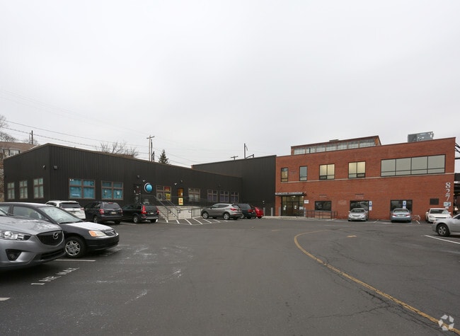
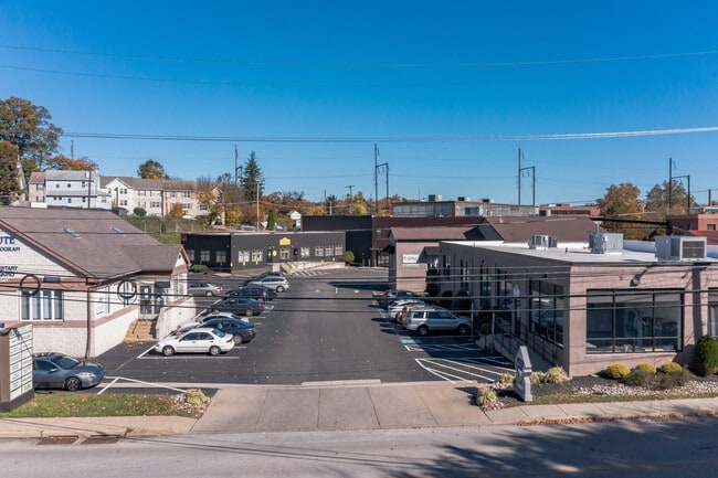
Property Record
Rices Mill Rd, Wyncote, PA 19095

NEARBY LISTINGS FOR SALE OR LEASE
-
-
View all Wyncote listings for lease on LoopNet.com
Property Detail
Rices Mill Rd
Philadelphia-Camden-Wilmington, PA-NJ-DE-MD
Rices Mill & Glenside Ave
31-00-22834-004
ASSESSOR BLOCK-UNIT NUMBER 149-86
Parkinglot
Montgomery
AE
Pennsylvania
42091C0382G
86
2024
2.38 AC
2025
East Montgomery Cty
202500
Philadelphia
DEMOGRAPHICS near Rices Mill Rd
1 Mile
3 Mile
5 Mile
2024 Total Population
18,627
151,673
424,659
2029 Population
19,050
151,823
417,078
Pop Growth 2024-2029
+ 2.27%
+ 0.10%
(1.79%)
Average Age
41
42
41
2024 Total Households
7,320
60,204
166,087
HH Growth 2024-2029
+ 2.32%
+ 0.07%
(1.95%)
Median Household Inc
$113,787
$83,342
$68,662
Avg Household Size
2.40
2.40
2.40
2024 Avg HH Vehicles
2.00
2.00
1.00
Median Home Value
$365,736
$294,111
$267,710
Median Year Built
1948
1953
1952
Nearby Places
Map Layers
Map Styles
 Street
 Aerial
- Restaurants
- Banks
- Shops
- Fitness
- Groceries
PUBLIC TRANSPORTATION
TRANSIT/SUBWAY
Glenside (R1 - Southeastern Pennsylvania Transportation Authority Regional Rail (SEPTA Regional Rail), R2 - Southeastern Pennsylvania Transportation Authority Regional Rail (SEPTA Regional Rail), R5 - Southeastern Pennsylvania Transportation Authority Regional Rail (SEPTA Regional Rail))
DRIVE
WALK
Distance
Glenside (R1 - Southeastern Pennsylvania Transportation Authority Regional Rail (SEPTA Regional Rail), R2 - Southeastern Pennsylvania Transportation Authority Regional Rail (SEPTA Regional Rail), R5 - Southeastern Pennsylvania Transportation Authority Regional Rail (SEPTA Regional Rail))
3 min
13 min
0.7 mi
Jenkintown-Wyncote (R1 - Southeastern Pennsylvania Transportation Authority Regional Rail (SEPTA Regional Rail), R2 - Southeastern Pennsylvania Transportation Authority Regional Rail (SEPTA Regional Rail), R3 - Southeastern Pennsylvania Transportation Authority Regional Rail (SEPTA Regional Rail), R5 - Southeastern Pennsylvania Transportation Authority Regional Rail (SEPTA Regional Rail))
DRIVE
WALK
Distance
Jenkintown-Wyncote (R1 - Southeastern Pennsylvania Transportation Authority Regional Rail (SEPTA Regional Rail), R2 - Southeastern Pennsylvania Transportation Authority Regional Rail (SEPTA Regional Rail), R3 - Southeastern Pennsylvania Transportation Authority Regional Rail (SEPTA Regional Rail), R5 - Southeastern Pennsylvania Transportation Authority Regional Rail (SEPTA Regional Rail))
4 min
14 min
0.7 mi
COMMUTER RAIL
Glenside (R1 - Southeastern Pennsylvania Transportation Authority Regional Rail (SEPTA Regional Rail), R2 - Southeastern Pennsylvania Transportation Authority Regional Rail (SEPTA Regional Rail), R5 - Southeastern Pennsylvania Transportation Authority Regional Rail (SEPTA Regional Rail))
DRIVE
WALK
Distance
Glenside (R1 - Southeastern Pennsylvania Transportation Authority Regional Rail (SEPTA Regional Rail), R2 - Southeastern Pennsylvania Transportation Authority Regional Rail (SEPTA Regional Rail), R5 - Southeastern Pennsylvania Transportation Authority Regional Rail (SEPTA Regional Rail))
3 min
13 min
0.7 mi
Jenkintown-Wyncote (R1 - Southeastern Pennsylvania Transportation Authority Regional Rail (SEPTA Regional Rail), R2 - Southeastern Pennsylvania Transportation Authority Regional Rail (SEPTA Regional Rail), R3 - Southeastern Pennsylvania Transportation Authority Regional Rail (SEPTA Regional Rail), R5 - Southeastern Pennsylvania Transportation Authority Regional Rail (SEPTA Regional Rail))
DRIVE
WALK
Distance
Jenkintown-Wyncote (R1 - Southeastern Pennsylvania Transportation Authority Regional Rail (SEPTA Regional Rail), R2 - Southeastern Pennsylvania Transportation Authority Regional Rail (SEPTA Regional Rail), R3 - Southeastern Pennsylvania Transportation Authority Regional Rail (SEPTA Regional Rail), R5 - Southeastern Pennsylvania Transportation Authority Regional Rail (SEPTA Regional Rail))
4 min
14 min
0.7 mi
AIRPORT
Philadelphia International
DRIVE
WALK
Distance
Philadelphia International
42 min
22.7 mi
Trenton Mercer
DRIVE
WALK
Distance
Trenton Mercer
47 min
26.1 mi
Freight Ports
Port of Philadelphia
DRIVE
WALK
Distance
Port of Philadelphia
20 min
10.5 mi
SALE & LEASE HISTORY
LISTING DATE
SALE/LEASE

Nov 23, 2022
For Sale
Nov 12, 2025
For Lease
May 04, 2025
For Sale
Mar 21, 2017
For Lease
Jul 21, 2022
For Lease
Dec 08, 2017
For Sale
Aug 13, 2020
For Lease
Apr 16, 2020
For Lease
Apr 12, 2017
For Lease
Nearby Properties
Address
Land Use
TOTAL SIZE
Lot Size
Zoning
Address
Land Use
TOTAL SIZE
Lot Size
Zoning
1,556,628 SF
7.70 AC
AO
Address
Land Use
TOTAL SIZE
Lot Size
Zoning
638,776 SF
20 AC
RM2
Address
Land Use
TOTAL SIZE
Lot Size
Zoning
2,146,150 SF
119.95 AC
M1
Address
Land Use
TOTAL SIZE
Lot Size
Zoning
649,400 SF
55.03 AC
R1
Address
Land Use
TOTAL SIZE
Lot Size
Zoning
487,936 SF
58.50 AC
T
Address
Land Use
TOTAL SIZE
Lot Size
Zoning
705,687 SF
19.89 AC
C1
Address
Land Use
TOTAL SIZE
Lot Size
Zoning
263,000 SF
5.31 AC
RM2
Address
Land Use
TOTAL SIZE
Lot Size
Zoning
234,934 SF
43.63 AC
AA
Address
Land Use
TOTAL SIZE
Lot Size
Zoning
635,387 SF
10.12 AC
C1
Address
Land Use
TOTAL SIZE
Lot Size
Zoning
316,163 SF
45.32 AC
T
Address
Land Use
TOTAL SIZE
Lot Size
Zoning
557,091 SF
21.87 AC
AO
Address
Land Use
TOTAL SIZE
Lot Size
Zoning
222,235 SF
29.23 AC
A
Address
Land Use
TOTAL SIZE
Lot Size
Zoning
582,294 SF
9.07 AC
C1
Address
Land Use
TOTAL SIZE
Lot Size
Zoning
615,217 SF
33.52 AC
C2
Address
Land Use
TOTAL SIZE
Lot Size
Zoning
182,130 SF
6.45 AC
RSA3
Address
Land Use
TOTAL SIZE
Lot Size
Zoning
180,066 SF
59.77 AC
RSA3
Address
Land Use
TOTAL SIZE
Lot Size
Zoning
435,888 SF
16.35 AC
MD
Address
Land Use
TOTAL SIZE
Lot Size
Zoning
336,650 SF
61.74 AC
R3
Address
Land Use
TOTAL SIZE
Lot Size
Zoning
73,382 SF
3.81 AC
RSA2
Address
Land Use
TOTAL SIZE
Lot Size
Zoning
232,190 SF
34.16 AC
R4
Address
Land Use
TOTAL SIZE
Lot Size
Zoning
259,505 SF
42.19 AC
V
Address
Land Use
TOTAL SIZE
Lot Size
Zoning
130,115 SF
10.45 AC
PB
Address
Land Use
TOTAL SIZE
Lot Size
Zoning
139,087 SF
2.76 AC
V
Address
Land Use
TOTAL SIZE
Lot Size
Zoning
232,000 SF
13.71 AC
RSA3
Address
Land Use
TOTAL SIZE
Lot Size
Zoning
566,988 SF
29.69 AC
C2
Address
Land Use
TOTAL SIZE
Lot Size
Zoning
574,944 SF
5.45 AC
F2
Address
Land Use
TOTAL SIZE
Lot Size
Zoning
336,463 SF
7.52 AC
Address
Land Use
TOTAL SIZE
Lot Size
Zoning
193,334 SF
32.50 AC
NR
Address
Land Use
TOTAL SIZE
Lot Size
Zoning
250,749 SF
47.90 AC
V
Address
Land Use
TOTAL SIZE
Lot Size
Zoning
160,029 SF
28.56 AC
R3
The World's #1 Commercial Real Estate Marketplace
Connect with us
© 2026 CoStar Group
The information above has been obtained from sources believed reliable. While we do not doubt its accuracy we have not verified it and make no guarantee, warranty or representation about it. It is your responsibility to independently confirm its accuracy and completeness. Any projections, opinions, assumptions, or estimates used are for example only and do not represent the current or future performance of the property. The value of this transaction to you depends on tax and other factors which should be evaluated by your tax, financial, and legal advisors. You and your advisors should conduct a careful, independent investigation of the property to determine to your satisfaction the suitability of the property for your needs.