Property Record
Ridge Rd, Enoree, SC 29335

Property Detail
Ridge Rd
Spartanburg, SC
TR 2 CHARLES CURTIS RHODES, TRUSTEE UNDER DECLARATION OF TRUST SUR DB 35D-284 PB 181-851
5-11-00-074.00
SPARTANBURG
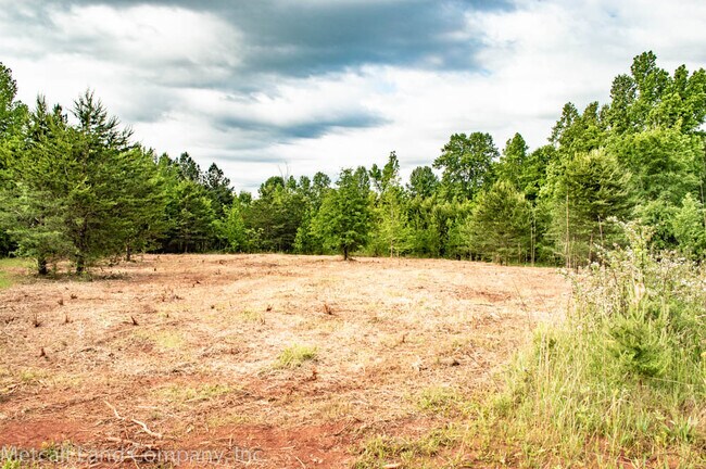
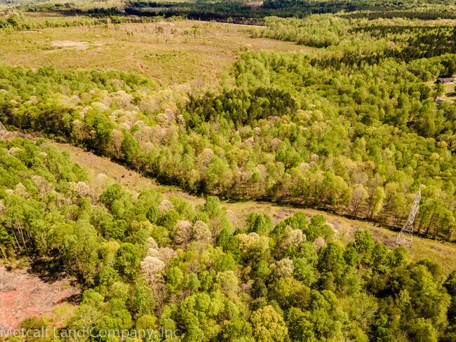
Agriculturalland
South Carolina
AE The base floodplain where base flood elevations are provided. AE Zones are now used on new format FIRMs instead of A1-A30 Zones.
1c,1d
2024
31.88 AC
2025
Upper Spartanburg County
023700
Greenville/Spartanburg
NEARBY LISTINGS FOR SALE OR LEASE
DEMOGRAPHICS near Ridge Rd
1 mile
3 mile
5 mile
2025 Total Population
3,358
22,499
53,030
2030 Population
3,709
25,074
59,208
Pop Growth 2025-2030
+ 10.45%
+ 11.44%
+ 11.65%
Average Age
39
37
38
2025 Total Households
1,355
8,529
19,470
HH Growth 2025-2030
+ 10.48%
+ 11.47%
+ 11.79%
Median Household Inc
$53,049
$61,390
$69,410
Avg Household Size
2.40
2.60
2.60
2025 Avg HH Vehicles
2.00
2.00
2.00
Median Home Value
$212,214
$237,818
$260,466
Median Year Built
1976
1994
1999
Nearby Places
Map Layers
Map Styles
 Street
 Aerial
Transit
 Traffic
 Biking
Places
Listings with unknown addresses are not visible on the map
- Restaurants
- Banks
- Shops
- Fitness
- Groceries
PUBLIC TRANSPORTATION
AIRPORT
Greenville Spartanburg International
Drive
Walk
Distance
Greenville Spartanburg International
24 min
12.1 mi
Freight Ports
North Charleston Terminal
Drive
Walk
Distance
North Charleston Terminal
232 min
202.9 mi
SALE & LEASE HISTORY
LISTING DATE
SALE/LEASE

Sep 17, 2021
For Sale
Nearby Properties
Address
Land Use
TOTAL SIZE
Lot Size
Zoning
Address
Land Use
TOTAL SIZE
Lot Size
Zoning
451,000 SF
47.03 AC
Address
Land Use
TOTAL SIZE
Lot Size
Zoning
102.67 AC
Address
Land Use
TOTAL SIZE
Lot Size
Zoning
33.57 AC
Address
Land Use
TOTAL SIZE
Lot Size
Zoning
1,964,569 SF
46.64 AC
Address
Land Use
TOTAL SIZE
Lot Size
Zoning
28.26 AC
Address
Land Use
TOTAL SIZE
Lot Size
Zoning
67,938 SF
8.02 AC
Address
Land Use
TOTAL SIZE
Lot Size
Zoning
Address
Land Use
TOTAL SIZE
Lot Size
Zoning
3,105 SF
6.12 AC
Address
Land Use
TOTAL SIZE
Lot Size
Zoning
Address
Land Use
TOTAL SIZE
Lot Size
Zoning
31,301 SF
5 AC
Address
Land Use
TOTAL SIZE
Lot Size
Zoning
4,070 SF
0.96 AC
Address
Land Use
TOTAL SIZE
Lot Size
Zoning
8,335 SF
1.60 AC
Address
Land Use
TOTAL SIZE
Lot Size
Zoning
Address
Land Use
TOTAL SIZE
Lot Size
Zoning
4,332 SF
1.06 AC
Address
Land Use
TOTAL SIZE
Lot Size
Zoning
3,314 SF
0.58 AC
Address
Land Use
TOTAL SIZE
Lot Size
Zoning
4,325 SF
0.34 AC
Address
Land Use
TOTAL SIZE
Lot Size
Zoning
10,684 SF
11.39 AC
Address
Land Use
TOTAL SIZE
Lot Size
Zoning
4,472 SF
2.96 AC
Address
Land Use
TOTAL SIZE
Lot Size
Zoning
3,066 SF
0.58 AC
Address
Land Use
TOTAL SIZE
Lot Size
Zoning
3,157 SF
0.34 AC
Address
Land Use
TOTAL SIZE
Lot Size
Zoning
71,373 SF
5.18 AC
Address
Land Use
TOTAL SIZE
Lot Size
Zoning
4,504 SF
0.43 AC
Address
Land Use
TOTAL SIZE
Lot Size
Zoning
3,292 SF
0.57 AC
Address
Land Use
TOTAL SIZE
Lot Size
Zoning
47,718 SF
7.83 AC
Address
Land Use
TOTAL SIZE
Lot Size
Zoning
2,807 SF
0.55 AC
Address
Land Use
TOTAL SIZE
Lot Size
Zoning
3,101 SF
0.63 AC
Address
Land Use
TOTAL SIZE
Lot Size
Zoning
3,049 SF
0.35 AC
Address
Land Use
TOTAL SIZE
Lot Size
Zoning
2,878 SF
0.44 AC
Address
Land Use
TOTAL SIZE
Lot Size
Zoning
2,637 SF
0.51 AC
Address
Land Use
TOTAL SIZE
Lot Size
Zoning
2,710 SF
The World's #1 Commercial Real Estate Marketplace
Connect with us
© 2026 CoStar Group
The information above has been obtained from sources believed reliable. While we do not doubt its accuracy we have not verified it and make no guarantee, warranty or representation about it. It is your responsibility to independently confirm its accuracy and completeness. Any projections, opinions, assumptions, or estimates used are for example only and do not represent the current or future performance of the property. The value of this transaction to you depends on tax and other factors which should be evaluated by your tax, financial, and legal advisors. You and your advisors should conduct a careful, independent investigation of the property to determine to your satisfaction the suitability of the property for your needs.