Property Record
Ridge Rd, Mount Airy, MD 21771
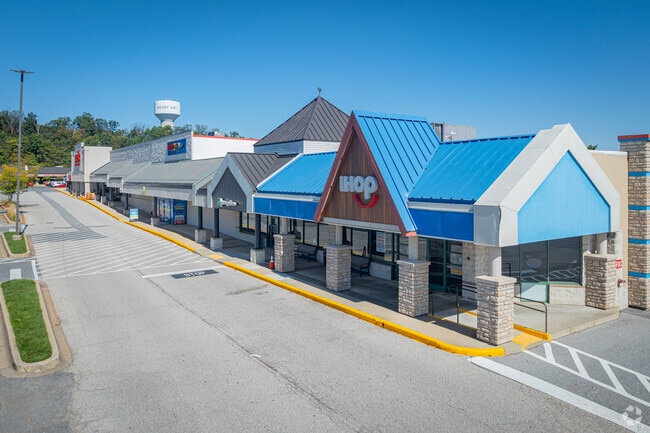

Current Lease Availabilities
Property Detail
Ridge Rd
13-010374
12.67 ACS W/S RIDGE RD N OF MOUNT AIRY
Commercialacreage
CARROLL
CC
Maryland
B and X Area of moderate flood hazard, usually the area between the limits of the 100-year and 500-year floods.
12.67 AC
2025
Carroll County
2025
Baltimore
513001
Baltimore-Columbia-Towson, MD
2,413 SF
NEARBY LISTINGS FOR SALE OR LEASE
DEMOGRAPHICS near Ridge Rd
1 mile
3 mile
5 mile
2025 Total Population
5,445
18,419
32,025
2030 Population
5,592
19,195
33,377
Pop Growth 2025-2030
+ 2.70%
+ 4.21%
+ 4.22%
Average Age
40
41
42
2025 Total Households
2,023
6,375
11,046
HH Growth 2025-2030
+ 2.72%
+ 4.25%
+ 4.25%
Median Household Inc
$124,590
$155,952
$158,718
Avg Household Size
2.60
2.80
2.90
2025 Avg HH Vehicles
2.00
2.00
3.00
Median Home Value
$411,994
$568,160
$606,773
Median Year Built
1989
1990
1987
Nearby Places
Map Layers
Map Styles
 Street
 Aerial
Layers
 Traffic
 Biking
Places
Listings with unknown addresses are not visible on the map
- Restaurants
- Banks
- Shops
- Fitness
- Groceries
PUBLIC TRANSPORTATION
AIRPORT
Baltimore/Washington International Thurgood Marshall
Drive
Walk
Distance
Baltimore/Washington International Thurgood Marshall
49 min
38.1 mi
Freight Ports
Port of Baltimore
Drive
Walk
Distance
Port of Baltimore
50 min
38.6 mi
Nearby Properties
Address
Land Use
TOTAL SIZE
Lot Size
Zoning
Address
Land Use
TOTAL SIZE
Lot Size
Zoning
51,451 SF
46.50 AC
R2
Address
Land Use
TOTAL SIZE
Lot Size
Zoning
11,120 SF
13.49 AC
CC
Address
Land Use
TOTAL SIZE
Lot Size
Zoning
48,427 SF
15.66 AC
CC
Address
Land Use
TOTAL SIZE
Lot Size
Zoning
70,452 SF
14.04 AC
RE
Address
Land Use
TOTAL SIZE
Lot Size
Zoning
6,280 SF
7.96 AC
CC
Address
Land Use
TOTAL SIZE
Lot Size
Zoning
92,230 SF
12.58 AC
CC
Address
Land Use
TOTAL SIZE
Lot Size
Zoning
88,906 SF
5.63 AC
R5
Address
Land Use
TOTAL SIZE
Lot Size
Zoning
153.21 AC
CONSE
Address
Land Use
TOTAL SIZE
Lot Size
Zoning
44,600 SF
2.28 AC
CC
Address
Land Use
TOTAL SIZE
Lot Size
Zoning
13,075 SF
37.13 AC
CONSE
Address
Land Use
TOTAL SIZE
Lot Size
Zoning
102,196 SF
13.87 AC
CC
Address
Land Use
TOTAL SIZE
Lot Size
Zoning
6,936 SF
5.18 AC
R7
Address
Land Use
TOTAL SIZE
Lot Size
Zoning
23,275 SF
7 AC
INDUS
Address
Land Use
TOTAL SIZE
Lot Size
Zoning
4,200 SF
5 AC
INDUS
Address
Land Use
TOTAL SIZE
Lot Size
Zoning
4,440 SF
1.05 AC
CC
Address
Land Use
TOTAL SIZE
Lot Size
Zoning
34.42 AC
CONSE
Address
Land Use
TOTAL SIZE
Lot Size
Zoning
27,013 SF
3.90 AC
RE
Address
Land Use
TOTAL SIZE
Lot Size
Zoning
57,399 SF
2.57 AC
CC
Address
Land Use
TOTAL SIZE
Lot Size
Zoning
17,468 SF
4.69 AC
INDUS
Address
Land Use
TOTAL SIZE
Lot Size
Zoning
49,140 SF
3.32 AC
I
Address
Land Use
TOTAL SIZE
Lot Size
Zoning
16,209 SF
3.14 AC
R7
Address
Land Use
TOTAL SIZE
Lot Size
Zoning
26,445 SF
2.22 AC
INDUS
Address
Land Use
TOTAL SIZE
Lot Size
Zoning
29,813 SF
0.48 AC
DTZ
Address
Land Use
TOTAL SIZE
Lot Size
Zoning
34,402 SF
2.96 AC
CC
Address
Land Use
TOTAL SIZE
Lot Size
Zoning
11,480 SF
1.20 AC
CC
Address
Land Use
TOTAL SIZE
Lot Size
Zoning
38,941 SF
3.22 AC
DTZ
Address
Land Use
TOTAL SIZE
Lot Size
Zoning
9,200 SF
1.30 AC
RE
Address
Land Use
TOTAL SIZE
Lot Size
Zoning
11,116 SF
8.74 AC
RCDEO
Address
Land Use
TOTAL SIZE
Lot Size
Zoning
28,656 SF
1.63 AC
CC
Address
Land Use
TOTAL SIZE
Lot Size
Zoning
75,659 SF
29.58 AC
LI
The World's #1 Commercial Real Estate Marketplace
Connect with us
© 2026 CoStar Group
The information above has been obtained from sources believed reliable. While we do not doubt its accuracy we have not verified it and make no guarantee, warranty or representation about it. It is your responsibility to independently confirm its accuracy and completeness. Any projections, opinions, assumptions, or estimates used are for example only and do not represent the current or future performance of the property. The value of this transaction to you depends on tax and other factors which should be evaluated by your tax, financial, and legal advisors. You and your advisors should conduct a careful, independent investigation of the property to determine to your satisfaction the suitability of the property for your needs.