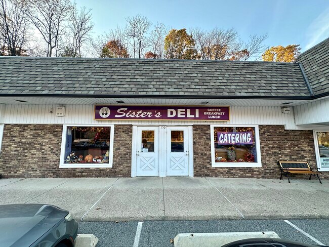
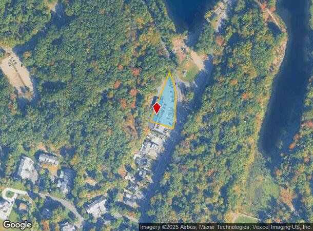
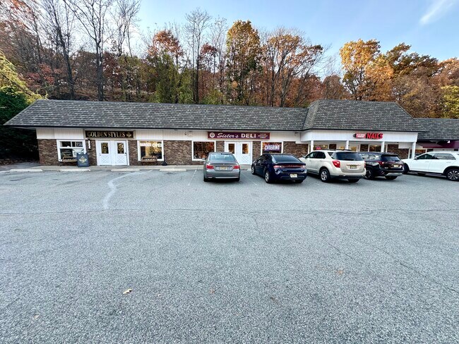
Property Record
Rifle Camp Rd, Woodland Park, NJ 07424
NEARBY LISTINGS FOR SALE OR LEASE
Property Detail
Rifle Camp Rd
16-00041-0000-00009-01
Passaic
Regionalshoppingcenterormallwithanchorstore
New Jersey
X
9.1
34031C0218G
0.60 AC
2024
Passaic Rt 46/23
2025
Northern New Jersey
264102
New York-Jersey City-White Plains, NY-NJ
7,000 SF
DEMOGRAPHICS near Rifle Camp Rd
1 Mile
3 Mile
5 Mile
2024 Total Population
18,279
243,032
544,185
2029 Population
17,496
233,621
527,179
Pop Growth 2024-2029
(4.28%)
(3.87%)
(3.13%)
Average Age
39
38
39
2024 Total Households
6,382
79,693
182,963
HH Growth 2024-2029
(4.50%)
(3.93%)
(3.23%)
Median Household Inc
$76,511
$66,387
$75,954
Avg Household Size
2.80
2.90
2.80
2024 Avg HH Vehicles
2.00
1.00
2.00
Median Home Value
$377,849
$391,533
$444,896
Median Year Built
1961
1954
1954
Nearby Places
Map Layers
Map Styles
 Street
 Aerial
- Restaurants
- Banks
- Shops
- Fitness
- Groceries
PUBLIC TRANSPORTATION
COMMUTER RAIL
Paterson (Main/Port Jervis Line - NJ Transit Commuter Rail (NJ Transit))
DRIVE
WALK
Distance
Paterson (Main/Port Jervis Line - NJ Transit Commuter Rail (NJ Transit))
5 min
2.1 mi
Montclair State University (Montclair-Boonton Line - NJ Transit Commuter Rail (NJ Transit))
DRIVE
WALK
Distance
Montclair State University (Montclair-Boonton Line - NJ Transit Commuter Rail (NJ Transit))
6 min
2.6 mi
AIRPORT
Newark Liberty International
DRIVE
WALK
Distance
Newark Liberty International
26 min
20.1 mi
LaGuardia
DRIVE
WALK
Distance
LaGuardia
39 min
26.5 mi
Westchester County
DRIVE
WALK
Distance
Westchester County
59 min
42.2 mi
Freight Ports
Maher Terminal
DRIVE
WALK
Distance
Maher Terminal
33 min
19.9 mi
SALE & LEASE HISTORY
LISTING DATE
SALE/LEASE

Nov 20, 2024
For Lease
Nearby Properties
Address
Land Use
TOTAL SIZE
Lot Size
Zoning
Address
Land Use
TOTAL SIZE
Lot Size
Zoning
8.75 AC
Address
Land Use
TOTAL SIZE
Lot Size
Zoning
12,506 SF
130 AC
B-2
Address
Land Use
TOTAL SIZE
Lot Size
Zoning
56.67 AC
Address
Land Use
TOTAL SIZE
Lot Size
Zoning
28.33 AC
Address
Land Use
TOTAL SIZE
Lot Size
Zoning
260,609 SF
35.39 AC
Address
Land Use
TOTAL SIZE
Lot Size
Zoning
20.43 AC
Address
Land Use
TOTAL SIZE
Lot Size
Zoning
79,310 SF
2 AC
B-2
Address
Land Use
TOTAL SIZE
Lot Size
Zoning
26,816 SF
25.50 AC
POP
Address
Land Use
TOTAL SIZE
Lot Size
Zoning
24,200 SF
19.33 AC
Address
Land Use
TOTAL SIZE
Lot Size
Zoning
152,050 SF
1.96 AC
B-1
Address
Land Use
TOTAL SIZE
Lot Size
Zoning
315,332 SF
19.60 AC
Address
Land Use
TOTAL SIZE
Lot Size
Zoning
7.83 AC
Address
Land Use
TOTAL SIZE
Lot Size
Zoning
3.55 AC
Address
Land Use
TOTAL SIZE
Lot Size
Zoning
12.86 AC
Address
Land Use
TOTAL SIZE
Lot Size
Zoning
1.80 AC
Address
Land Use
TOTAL SIZE
Lot Size
Zoning
0.69 AC
I-1
Address
Land Use
TOTAL SIZE
Lot Size
Zoning
25.80 AC
P
Address
Land Use
TOTAL SIZE
Lot Size
Zoning
271,679 SF
20.79 AC
Address
Land Use
TOTAL SIZE
Lot Size
Zoning
1,512 SF
90 AC
Address
Land Use
TOTAL SIZE
Lot Size
Zoning
21.80 AC
R-A3
Address
Land Use
TOTAL SIZE
Lot Size
Zoning
49.03 AC
Address
Land Use
TOTAL SIZE
Lot Size
Zoning
342,518 SF
31.80 AC
IP
Address
Land Use
TOTAL SIZE
Lot Size
Zoning
648 SF
108.80 AC
Address
Land Use
TOTAL SIZE
Lot Size
Zoning
1,482 SF
55.66 AC
R-B
Address
Land Use
TOTAL SIZE
Lot Size
Zoning
14,152 SF
23.87 AC
Address
Land Use
TOTAL SIZE
Lot Size
Zoning
15.80 AC
IND
Address
Land Use
TOTAL SIZE
Lot Size
Zoning
764,364 SF
16.60 AC
I-2
Address
Land Use
TOTAL SIZE
Lot Size
Zoning
11.87 AC
Address
Land Use
TOTAL SIZE
Lot Size
Zoning
0.12 AC
Address
Land Use
TOTAL SIZE
Lot Size
Zoning
17.48 AC
M-2
The World's #1 Commercial Real Estate Marketplace
Connect with us
© 2025 CoStar Group
The information above has been obtained from sources believed reliable. While we do not doubt its accuracy we have not verified it and make no guarantee, warranty or representation about it. It is your responsibility to independently confirm its accuracy and completeness. Any projections, opinions, assumptions, or estimates used are for example only and do not represent the current or future performance of the property. The value of this transaction to you depends on tax and other factors which should be evaluated by your tax, financial, and legal advisors. You and your advisors should conduct a careful, independent investigation of the property to determine to your satisfaction the suitability of the property for your needs.