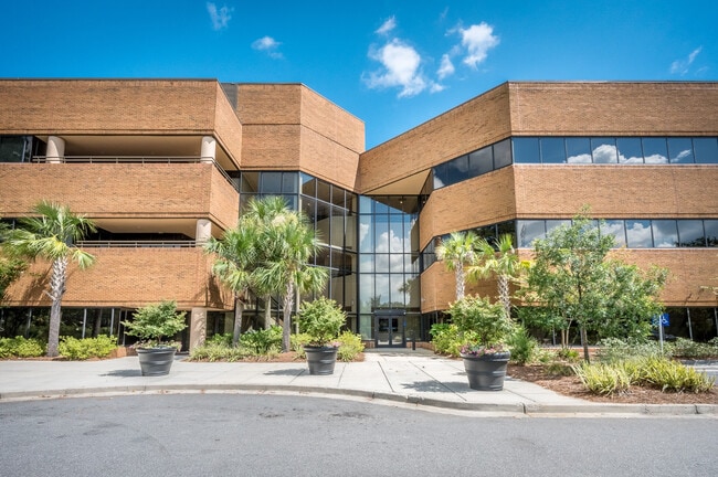
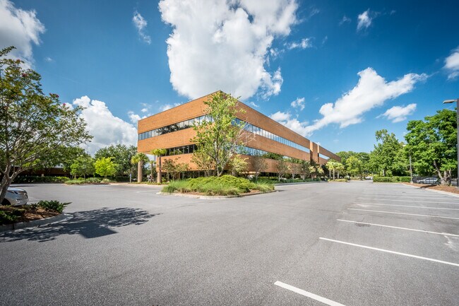
Property Record
Rifle Range Rd, Mount Pleasant, SC 29466

Current Lease Availabilities
Property Detail
Rifle Range Rd
Charleston-North Charleston, SC
SUBDIVISION NAME -GOODRICH INDUSTRIAL PARK DESCRIPTION -PHASE II SITE NAME -RIVERGATE CENTER 2 OF 2
577-00-00-315
CHARLESTON
Residentialacreage
South Carolina
2025
55.23 AC
2024
North Charleston
003111
Charleston/N Charleston
NEARBY LISTINGS FOR SALE OR LEASE
DEMOGRAPHICS near Rifle Range Rd
1 mile
3 mile
5 mile
2025 Total Population
4,506
56,977
123,939
2030 Population
4,854
60,638
130,922
Pop Growth 2025-2030
+ 7.72%
+ 6.43%
+ 5.63%
Average Age
38
38
39
2025 Total Households
1,875
22,915
51,190
HH Growth 2025-2030
+ 7.73%
+ 6.59%
+ 5.68%
Median Household Inc
$52,238
$61,411
$68,872
Avg Household Size
2.30
2.30
2.30
2025 Avg HH Vehicles
1.00
2.00
2.00
Median Home Value
$160,795
$264,050
$331,096
Median Year Built
1983
1976
1982
Nearby Places
Map Layers
Map Styles
 Street
 Aerial
Layers
 Traffic
 Biking
Places
Listings with unknown addresses are not visible on the map
- Restaurants
- Banks
- Shops
- Fitness
- Groceries
PUBLIC TRANSPORTATION
AIRPORT
Charleston AFB/International
Drive
Walk
Distance
Charleston AFB/International
36 min
22.2 mi
Freight Ports
Wando Welch Terminal
Drive
Walk
Distance
Wando Welch Terminal
15 min
6.8 mi
Nearby Properties
Address
Land Use
TOTAL SIZE
Lot Size
Zoning
Address
Land Use
TOTAL SIZE
Lot Size
Zoning
19.70 AC
Address
Land Use
TOTAL SIZE
Lot Size
Zoning
20.24 AC
Address
Land Use
TOTAL SIZE
Lot Size
Zoning
Address
Land Use
TOTAL SIZE
Lot Size
Zoning
10,948 SF
1.94 AC
Address
Land Use
TOTAL SIZE
Lot Size
Zoning
24,836 SF
10.63 AC
Address
Land Use
TOTAL SIZE
Lot Size
Zoning
9.11 AC
Address
Land Use
TOTAL SIZE
Lot Size
Zoning
Address
Land Use
TOTAL SIZE
Lot Size
Zoning
6,622 SF
20.06 AC
Address
Land Use
TOTAL SIZE
Lot Size
Zoning
3.76 AC
Address
Land Use
TOTAL SIZE
Lot Size
Zoning
2,646 SF
16.35 AC
Address
Land Use
TOTAL SIZE
Lot Size
Zoning
Address
Land Use
TOTAL SIZE
Lot Size
Zoning
Address
Land Use
TOTAL SIZE
Lot Size
Zoning
Address
Land Use
TOTAL SIZE
Lot Size
Zoning
Address
Land Use
TOTAL SIZE
Lot Size
Zoning
5,209 SF
5.88 AC
Address
Land Use
TOTAL SIZE
Lot Size
Zoning
1,104 SF
13.70 AC
Address
Land Use
TOTAL SIZE
Lot Size
Zoning
1,010 SF
Address
Land Use
TOTAL SIZE
Lot Size
Zoning
864 SF
22.36 AC
Address
Land Use
TOTAL SIZE
Lot Size
Zoning
Address
Land Use
TOTAL SIZE
Lot Size
Zoning
12.60 AC
Address
Land Use
TOTAL SIZE
Lot Size
Zoning
30,495 SF
8.73 AC
Address
Land Use
TOTAL SIZE
Lot Size
Zoning
45,969 SF
10.76 AC
Address
Land Use
TOTAL SIZE
Lot Size
Zoning
Address
Land Use
TOTAL SIZE
Lot Size
Zoning
Address
Land Use
TOTAL SIZE
Lot Size
Zoning
Address
Land Use
TOTAL SIZE
Lot Size
Zoning
38,788 SF
10.28 AC
Address
Land Use
TOTAL SIZE
Lot Size
Zoning
Address
Land Use
TOTAL SIZE
Lot Size
Zoning
57,840 SF
16.71 AC
Address
Land Use
TOTAL SIZE
Lot Size
Zoning
1,910 SF
7.59 AC
Address
Land Use
TOTAL SIZE
Lot Size
Zoning
8,080 SF
8.82 AC
The World's #1 Commercial Real Estate Marketplace
Connect with us
© 2026 CoStar Group
The information above has been obtained from sources believed reliable. While we do not doubt its accuracy we have not verified it and make no guarantee, warranty or representation about it. It is your responsibility to independently confirm its accuracy and completeness. Any projections, opinions, assumptions, or estimates used are for example only and do not represent the current or future performance of the property. The value of this transaction to you depends on tax and other factors which should be evaluated by your tax, financial, and legal advisors. You and your advisors should conduct a careful, independent investigation of the property to determine to your satisfaction the suitability of the property for your needs.