Property Record
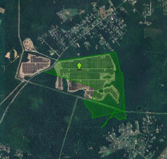
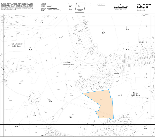
Ripley Rd, La Plata, MD 20646

Property Detail
Ripley Rd
02-004216
P/O PAR B & PAR C E SI RIPLEY RD S OF 225
Commercialnec
CHARLES
RC
Maryland
A Areas with a 1% annual chance of flooding and a 26% chance of flooding over the life of a 30-year mortgage.
198.71 AC
2025
Charles County
2025
Washington, DC
851001
Washington-Arlington-Alexandria, DC-VA-MD-WV
NEARBY LISTINGS FOR SALE OR LEASE
-
-
View all La Plata listings for sale on LoopNet.com
DEMOGRAPHICS near Ripley Rd
1 mile
3 mile
5 mile
2025 Total Population
525
3,077
10,066
2030 Population
542
3,184
10,440
Pop Growth 2025-2030
+ 3.24%
+ 3.48%
+ 3.72%
Average Age
42
43
44
2025 Total Households
176
1,086
3,664
HH Growth 2025-2030
+ 3.41%
+ 3.59%
+ 3.85%
Median Household Inc
$140,277
$116,666
$110,841
Avg Household Size
2.90
2.70
2.70
2025 Avg HH Vehicles
3.00
3.00
3.00
Median Home Value
$573,684
$488,341
$448,139
Median Year Built
2000
1994
1984
Nearby Places
Map Layers
Map Styles
 Street
 Aerial
Layers
 Traffic
 Biking
Places
Listings with unknown addresses are not visible on the map
- Restaurants
- Banks
- Shops
- Fitness
- Groceries
PUBLIC TRANSPORTATION
AIRPORT
Ronald Reagan Washington Ntl
Drive
Walk
Distance
Ronald Reagan Washington Ntl
57 min
32.0 mi
Freight Ports
Port of Baltimore
Drive
Walk
Distance
Port of Baltimore
102 min
67.9 mi
Nearby Properties
Address
Land Use
TOTAL SIZE
Lot Size
Zoning
Address
Land Use
TOTAL SIZE
Lot Size
Zoning
31,194 SF
6.05 AC
RC
Address
Land Use
TOTAL SIZE
Lot Size
Zoning
27,909 SF
10 AC
RC
Address
Land Use
TOTAL SIZE
Lot Size
Zoning
40.53 AC
WCD
Address
Land Use
TOTAL SIZE
Lot Size
Zoning
22,464 SF
4.99 AC
CN
Address
Land Use
TOTAL SIZE
Lot Size
Zoning
7,936 SF
4.10 AC
CN
Address
Land Use
TOTAL SIZE
Lot Size
Zoning
321.97 AC
RC
Address
Land Use
TOTAL SIZE
Lot Size
Zoning
1,683 SF
313.24 AC
WCD
Address
Land Use
TOTAL SIZE
Lot Size
Zoning
7,200 SF
5.07 AC
AC
Address
Land Use
TOTAL SIZE
Lot Size
Zoning
8,684 SF
2.23 AC
RC
Address
Land Use
TOTAL SIZE
Lot Size
Zoning
4,132 SF
114.56 AC
AC
Address
Land Use
TOTAL SIZE
Lot Size
Zoning
7,661 SF
2.13 AC
RC
Address
Land Use
TOTAL SIZE
Lot Size
Zoning
6,769 SF
4.69 AC
RC
Address
Land Use
TOTAL SIZE
Lot Size
Zoning
14,112 SF
2.57 AC
WCD
Address
Land Use
TOTAL SIZE
Lot Size
Zoning
6,425 SF
0.97 AC
RC
Address
Land Use
TOTAL SIZE
Lot Size
Zoning
3,454 SF
93.35 AC
WCD
Address
Land Use
TOTAL SIZE
Lot Size
Zoning
6,084 SF
19.33 AC
RC
Address
Land Use
TOTAL SIZE
Lot Size
Zoning
6,006 SF
1.87 AC
RC
Address
Land Use
TOTAL SIZE
Lot Size
Zoning
5,250 SF
39.27 AC
WCD
Address
Land Use
TOTAL SIZE
Lot Size
Zoning
5,271 SF
2.88 AC
CN
Address
Land Use
TOTAL SIZE
Lot Size
Zoning
4,921 SF
3.88 AC
RC
Address
Land Use
TOTAL SIZE
Lot Size
Zoning
5,184 SF
2.25 AC
RC
Address
Land Use
TOTAL SIZE
Lot Size
Zoning
5,083 SF
6.36 AC
AC
Address
Land Use
TOTAL SIZE
Lot Size
Zoning
138.46 AC
WCD
Address
Land Use
TOTAL SIZE
Lot Size
Zoning
4,590 SF
1.81 AC
RC
Address
Land Use
TOTAL SIZE
Lot Size
Zoning
7,042 SF
3.78 AC
AC
Address
Land Use
TOTAL SIZE
Lot Size
Zoning
5,006 SF
2.73 AC
RC
Address
Land Use
TOTAL SIZE
Lot Size
Zoning
5,588 SF
64.76 AC
RC
Address
Land Use
TOTAL SIZE
Lot Size
Zoning
3,518 SF
22.57 AC
WCD
Address
Land Use
TOTAL SIZE
Lot Size
Zoning
5,349 SF
1.27 AC
RC
The World's #1 Commercial Real Estate Marketplace
Connect with us
© 2026 CoStar Group
The information above has been obtained from sources believed reliable. While we do not doubt its accuracy we have not verified it and make no guarantee, warranty or representation about it. It is your responsibility to independently confirm its accuracy and completeness. Any projections, opinions, assumptions, or estimates used are for example only and do not represent the current or future performance of the property. The value of this transaction to you depends on tax and other factors which should be evaluated by your tax, financial, and legal advisors. You and your advisors should conduct a careful, independent investigation of the property to determine to your satisfaction the suitability of the property for your needs.