Property Record
Riverside Dr, Utica, NY 13502
Save to a Folder
{{folder.Name}}
{{folder.ListingIds.length}} Properties
{{folder.ListingIds.length}} Property
Create a New Folder
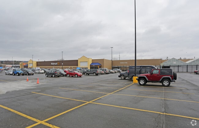
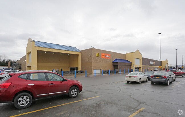
Property Detail
Riverside Dr
Utica-Rome, NY
7-7 - -446 298A CO 06/02 999.009-0009-418.000/0000
301600 306.12-1-80
ONEIDA
Communitycenter
New York
B and X Area of moderate flood hazard, usually the area between the limits of the 100-year and 500-year floods.
80.000
2025
7.90 AC
2025
Utica
980002
Utica/Rome
205,097 SF
NEARBY LISTINGS FOR SALE OR LEASE
DEMOGRAPHICS near Riverside Dr
1 mile
3 mile
5 mile
2025 Total Population
3,657
56,914
94,575
2030 Population
3,626
55,993
93,231
Pop Growth 2025-2030
(0.85%)
(1.62%)
(1.42%)
Average Age
45
38
40
2025 Total Households
1,632
22,373
37,796
HH Growth 2025-2030
(0.86%)
(1.55%)
(1.48%)
Median Household Inc
$81,737
$45,789
$53,532
Avg Household Size
2.10
2.40
2.30
2025 Avg HH Vehicles
2.00
1.00
1.00
Median Home Value
$168,429
$149,234
$172,781
Median Year Built
1958
1948
1951
Nearby Places
Map Layers
Map Styles
 Street
 Aerial
Layers
 Traffic
 Biking
Places
Listings with unknown addresses are not visible on the map
- Restaurants
- Banks
- Shops
- Fitness
- Groceries
PUBLIC TRANSPORTATION
COMMUTER RAIL
Drive
Walk
Distance
6 min
2.3 mi
Nearby Properties
Address
Land Use
TOTAL SIZE
Lot Size
Zoning
Address
Land Use
TOTAL SIZE
Lot Size
Zoning
656,100 SF
55.25 AC
Address
Land Use
TOTAL SIZE
Lot Size
Zoning
742,550 SF
2.03 AC
Address
Land Use
TOTAL SIZE
Lot Size
Zoning
65.34 AC
Address
Land Use
TOTAL SIZE
Lot Size
Zoning
9.79 AC
Address
Land Use
TOTAL SIZE
Lot Size
Zoning
276,146 SF
304.48 AC
Address
Land Use
TOTAL SIZE
Lot Size
Zoning
98,832 SF
1.61 AC
Address
Land Use
TOTAL SIZE
Lot Size
Zoning
279,786 SF
121 AC
Address
Land Use
TOTAL SIZE
Lot Size
Zoning
236,597 SF
2.10 AC
Address
Land Use
TOTAL SIZE
Lot Size
Zoning
50.30 AC
Address
Land Use
TOTAL SIZE
Lot Size
Zoning
6,000 SF
1.46 AC
Address
Land Use
TOTAL SIZE
Lot Size
Zoning
12,692 SF
20.24 AC
Address
Land Use
TOTAL SIZE
Lot Size
Zoning
53,777 SF
Address
Land Use
TOTAL SIZE
Lot Size
Zoning
55,916 SF
4.50 AC
Address
Land Use
TOTAL SIZE
Lot Size
Zoning
129,948 SF
6.90 AC
Address
Land Use
TOTAL SIZE
Lot Size
Zoning
132,972 SF
30.76 AC
Address
Land Use
TOTAL SIZE
Lot Size
Zoning
87,120 SF
2.31 AC
Address
Land Use
TOTAL SIZE
Lot Size
Zoning
133.60 AC
Address
Land Use
TOTAL SIZE
Lot Size
Zoning
3,472 SF
1.06 AC
Address
Land Use
TOTAL SIZE
Lot Size
Zoning
163,404 SF
2.58 AC
Address
Land Use
TOTAL SIZE
Lot Size
Zoning
65,120 SF
1.79 AC
Address
Land Use
TOTAL SIZE
Lot Size
Zoning
47,732 SF
0.86 AC
DS
Address
Land Use
TOTAL SIZE
Lot Size
Zoning
209,608 SF
2.10 AC
Address
Land Use
TOTAL SIZE
Lot Size
Zoning
142,770 SF
34.25 AC
Address
Land Use
TOTAL SIZE
Lot Size
Zoning
148,962 SF
31.10 AC
Address
Land Use
TOTAL SIZE
Lot Size
Zoning
31,023 SF
1.72 AC
Address
Land Use
TOTAL SIZE
Lot Size
Zoning
83,783 SF
0.53 AC
Address
Land Use
TOTAL SIZE
Lot Size
Zoning
115,704 SF
1.78 AC
Address
Land Use
TOTAL SIZE
Lot Size
Zoning
61,940 SF
5.31 AC
Address
Land Use
TOTAL SIZE
Lot Size
Zoning
21,296 SF
0.66 AC
The World's #1 Commercial Real Estate Marketplace
Connect with us
© 2026 CoStar Group
The information above has been obtained from sources believed reliable. While we do not doubt its accuracy we have not verified it and make no guarantee, warranty or representation about it. It is your responsibility to independently confirm its accuracy and completeness. Any projections, opinions, assumptions, or estimates used are for example only and do not represent the current or future performance of the property. The value of this transaction to you depends on tax and other factors which should be evaluated by your tax, financial, and legal advisors. You and your advisors should conduct a careful, independent investigation of the property to determine to your satisfaction the suitability of the property for your needs.