Property Record
Riverstone Blvd, Missouri City, TX 77459


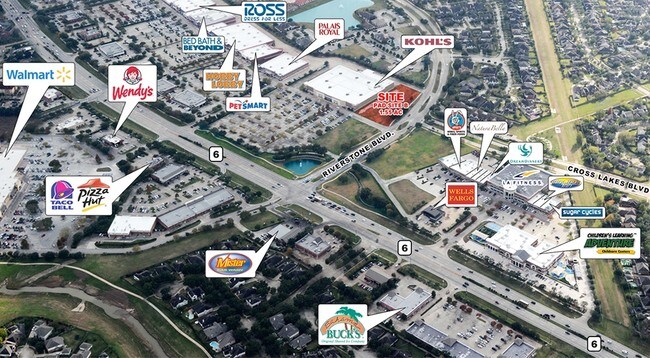
NEARBY LISTINGS FOR SALE OR LEASE
Property Detail
Riverstone Blvd
Houston-The Woodlands-Sugar Land, TX
The Shops At Riverstone Sec 1
6910-01-000-0010-907
THE SHOPS AT RIVERSTONE SEC 1, ACRES 1.553, RESERVE A
Commercialacreage
Fort Bend
X
Texas
48157C0280L
1.55 AC
2024
E Fort Bend Co/Sugar Land
2025
Houston
670904
DEMOGRAPHICS near Riverstone Blvd
1 Mile
3 Mile
5 Mile
2024 Total Population
10,698
108,691
205,591
2029 Population
12,749
130,012
246,157
Pop Growth 2024-2029
+ 19.17%
+ 19.62%
+ 19.73%
Average Age
41
40
40
2024 Total Households
3,532
37,155
71,047
HH Growth 2024-2029
+ 19.76%
+ 20.22%
+ 20.34%
Median Household Inc
$115,284
$97,541
$94,046
Avg Household Size
3.00
2.90
2.80
2024 Avg HH Vehicles
2.00
2.00
2.00
Median Home Value
$349,073
$330,037
$326,509
Median Year Built
1997
1994
1995
Nearby Places
Map Layers
Map Styles
 Street
 Aerial
- Restaurants
- Banks
- Shops
- Fitness
- Groceries
PUBLIC TRANSPORTATION
AIRPORT
William P Hobby
DRIVE
WALK
Distance
William P Hobby
39 min
24.4 mi
Freight Ports
Port of Houston
DRIVE
WALK
Distance
Port of Houston
41 min
27.3 mi
SALE & LEASE HISTORY
LISTING DATE
SALE/LEASE

Jul 31, 2017
For Lease
Aug 28, 2017
For Sale
Aug 02, 2017
For Lease
Nearby Properties
Address
Land Use
TOTAL SIZE
Lot Size
Zoning
Address
Land Use
TOTAL SIZE
Lot Size
Zoning
257,051 SF
64.85 AC
Address
Land Use
TOTAL SIZE
Lot Size
Zoning
109,083 SF
20.81 AC
Address
Land Use
TOTAL SIZE
Lot Size
Zoning
16.84 AC
Address
Land Use
TOTAL SIZE
Lot Size
Zoning
365,915 SF
57.06 AC
AT
Address
Land Use
TOTAL SIZE
Lot Size
Zoning
254,919 SF
12.46 AC
Address
Land Use
TOTAL SIZE
Lot Size
Zoning
85,273 SF
11.63 AC
Y
Address
Land Use
TOTAL SIZE
Lot Size
Zoning
14,038 SF
23.83 AC
Address
Land Use
TOTAL SIZE
Lot Size
Zoning
6.70 AC
Address
Land Use
TOTAL SIZE
Lot Size
Zoning
Address
Land Use
TOTAL SIZE
Lot Size
Zoning
127,458 SF
14.21 AC
Address
Land Use
TOTAL SIZE
Lot Size
Zoning
88,682 SF
10.52 AC
ASY
Address
Land Use
TOTAL SIZE
Lot Size
Zoning
149,261 SF
12.15 AC
SJ
Address
Land Use
TOTAL SIZE
Lot Size
Zoning
Address
Land Use
TOTAL SIZE
Lot Size
Zoning
88,560 SF
10.25 AC
QZ
Address
Land Use
TOTAL SIZE
Lot Size
Zoning
9.10 AC
Address
Land Use
TOTAL SIZE
Lot Size
Zoning
244,617 SF
9.34 AC
Address
Land Use
TOTAL SIZE
Lot Size
Zoning
189,336 SF
42.18 AC
MJT
Address
Land Use
TOTAL SIZE
Lot Size
Zoning
128,226 SF
11.40 AC
S
Address
Land Use
TOTAL SIZE
Lot Size
Zoning
189,336 SF
25.53 AC
S
Address
Land Use
TOTAL SIZE
Lot Size
Zoning
966,869 SF
16.14 AC
Address
Land Use
TOTAL SIZE
Lot Size
Zoning
120,046 SF
10.19 AC
QSXA
Address
Land Use
TOTAL SIZE
Lot Size
Zoning
65,653 SF
5 AC
X
Address
Land Use
TOTAL SIZE
Lot Size
Zoning
12.22 AC
OS
Address
Land Use
TOTAL SIZE
Lot Size
Zoning
73,196 SF
19.52 AC
SH
Address
Land Use
TOTAL SIZE
Lot Size
Zoning
126,941 SF
11.08 AC
Address
Land Use
TOTAL SIZE
Lot Size
Zoning
Address
Land Use
TOTAL SIZE
Lot Size
Zoning
193,365 SF
18.26 AC
Address
Land Use
TOTAL SIZE
Lot Size
Zoning
14.76 AC
Address
Land Use
TOTAL SIZE
Lot Size
Zoning
50,669 SF
22.59 AC
XSH
Address
Land Use
TOTAL SIZE
Lot Size
Zoning
18.90 AC
ATSN
The World's #1 Commercial Real Estate Marketplace
Connect with us
© 2026 CoStar Group
The information above has been obtained from sources believed reliable. While we do not doubt its accuracy we have not verified it and make no guarantee, warranty or representation about it. It is your responsibility to independently confirm its accuracy and completeness. Any projections, opinions, assumptions, or estimates used are for example only and do not represent the current or future performance of the property. The value of this transaction to you depends on tax and other factors which should be evaluated by your tax, financial, and legal advisors. You and your advisors should conduct a careful, independent investigation of the property to determine to your satisfaction the suitability of the property for your needs.