Property Record
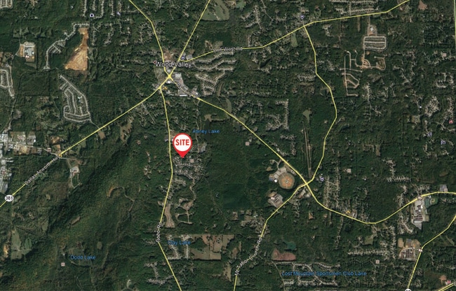
Riverwood Way, , GA

Save to a Folder
{{folder.Name}}
{{folder.ListingIds.length}} Properties
{{folder.ListingIds.length}} Property
Create a New Folder
Property Detail
Riverwood Way
Atlanta-Sandy Springs-Roswell, GA
REAL PROPERTY
106.4.2.088.0000
PAULDING
Commercialnec
Georgia
NB-100
olt
B and X Area of moderate flood hazard, usually the area between the limits of the 100-year and 500-year floods.
6.49 AC
2025
Kennesaw/Town Center
2025
Atlanta
1203023154
NEARBY LISTINGS FOR SALE OR LEASE
DEMOGRAPHICS near Riverwood Way
1 mile
3 mile
5 mile
2025 Total Population
3,272
37,469
95,768
2030 Population
3,613
41,326
104,357
Pop Growth 2025-2030
+ 10.42%
+ 10.29%
+ 8.97%
Average Age
38
38
38
2025 Total Households
1,094
12,941
32,316
HH Growth 2025-2030
+ 10.51%
+ 10.37%
+ 9.10%
Median Household Inc
$98,552
$106,846
$109,308
Avg Household Size
2.90
2.80
2.90
2025 Avg HH Vehicles
2.00
2.00
2.00
Median Home Value
$325,771
$342,617
$365,570
Median Year Built
2002
2002
2001
Nearby Places
Map Layers
Map Styles
 Street
 Aerial
Layers
 Traffic
 Biking
Places
Listings with unknown addresses are not visible on the map
- Restaurants
- Banks
- Shops
- Fitness
- Groceries
PUBLIC TRANSPORTATION
AIRPORT
Hartsfield - Jackson Atlanta International
Drive
Walk
Distance
Hartsfield - Jackson Atlanta International
61 min
39.3 mi
Freight Ports
Georgia Ports - Savannah
Drive
Walk
Distance
Georgia Ports - Savannah
324 min
278.7 mi
SALE & LEASE HISTORY
LISTING DATE
SALE/LEASE

May 13, 2021
For Sale
Nearby Properties
Address
Land Use
TOTAL SIZE
Lot Size
Zoning
Address
Land Use
TOTAL SIZE
Lot Size
Zoning
46.05 AC
Address
Land Use
TOTAL SIZE
Lot Size
Zoning
126,638 SF
20.26 AC
R4
Address
Land Use
TOTAL SIZE
Lot Size
Zoning
133,468 SF
12.37 AC
MF1
Address
Land Use
TOTAL SIZE
Lot Size
Zoning
25.10 AC
Address
Land Use
TOTAL SIZE
Lot Size
Zoning
187,435 SF
31.39 AC
R55
Address
Land Use
TOTAL SIZE
Lot Size
Zoning
37.28 AC
Address
Land Use
TOTAL SIZE
Lot Size
Zoning
41.85 AC
Address
Land Use
TOTAL SIZE
Lot Size
Zoning
19.14 AC
Address
Land Use
TOTAL SIZE
Lot Size
Zoning
179,316 SF
13.43 AC
MF1
Address
Land Use
TOTAL SIZE
Lot Size
Zoning
Address
Land Use
TOTAL SIZE
Lot Size
Zoning
18.44 AC
Address
Land Use
TOTAL SIZE
Lot Size
Zoning
151,906 SF
21.07 AC
B2
Address
Land Use
TOTAL SIZE
Lot Size
Zoning
71,122 SF
30.70 AC
OMI
Address
Land Use
TOTAL SIZE
Lot Size
Zoning
Address
Land Use
TOTAL SIZE
Lot Size
Zoning
7.69 AC
Address
Land Use
TOTAL SIZE
Lot Size
Zoning
80,738 SF
10.30 AC
B2
Address
Land Use
TOTAL SIZE
Lot Size
Zoning
74,036 SF
23.20 AC
B2
Address
Land Use
TOTAL SIZE
Lot Size
Zoning
128.92 AC
Address
Land Use
TOTAL SIZE
Lot Size
Zoning
45,560 SF
4.06 AC
OMI
Address
Land Use
TOTAL SIZE
Lot Size
Zoning
33,024 SF
5.41 AC
TH
Address
Land Use
TOTAL SIZE
Lot Size
Zoning
7.37 AC
Address
Land Use
TOTAL SIZE
Lot Size
Zoning
151.43 AC
Address
Land Use
TOTAL SIZE
Lot Size
Zoning
4,838 SF
3.42 AC
Address
Land Use
TOTAL SIZE
Lot Size
Zoning
62,098 SF
5.88 AC
DC2
Address
Land Use
TOTAL SIZE
Lot Size
Zoning
80,476 SF
23.36 AC
B2
Address
Land Use
TOTAL SIZE
Lot Size
Zoning
11,108 SF
1.89 AC
B1
Address
Land Use
TOTAL SIZE
Lot Size
Zoning
22,974 SF
3.61 AC
B1
Address
Land Use
TOTAL SIZE
Lot Size
Zoning
52,413 SF
7.57 AC
B2
Address
Land Use
TOTAL SIZE
Lot Size
Zoning
Address
Land Use
TOTAL SIZE
Lot Size
Zoning
16,288 SF
1.96 AC
B2
The World's #1 Commercial Real Estate Marketplace
Connect with us
© 2026 CoStar Group
The information above has been obtained from sources believed reliable. While we do not doubt its accuracy we have not verified it and make no guarantee, warranty or representation about it. It is your responsibility to independently confirm its accuracy and completeness. Any projections, opinions, assumptions, or estimates used are for example only and do not represent the current or future performance of the property. The value of this transaction to you depends on tax and other factors which should be evaluated by your tax, financial, and legal advisors. You and your advisors should conduct a careful, independent investigation of the property to determine to your satisfaction the suitability of the property for your needs.