Property Record
Robert Bryson Smith Pkwy, Bonaire, GA 31005
NEARBY LISTINGS FOR SALE OR LEASE
-
-
-
-
-
-
-
HWY 96 and Peach Blossom @ Peach Blossom Road
Bonaire, GA 31005
Rent Upon Request
10.06 AC Lots
Land
-
View all Bonaire listings for sale on LoopNet.com
Property Detail
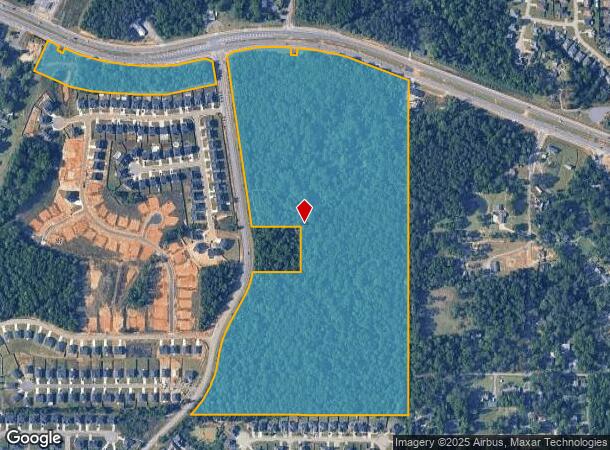
Robert Bryson Smith Pkwy
Warner Robins, GA
Boss King Group
0W1330014000
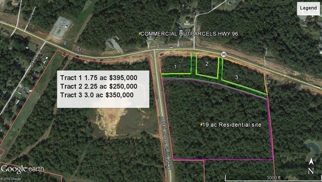
64.64 ACRES TRACT 1 LL 252 10LD
Residentialacreage
Houston
X
Georgia
13289C0200B
252
2024
64.64 AC
2024
Perry/Warner Robins
021115
Other Market Areas
DEMOGRAPHICS near Robert Bryson Smith Pkwy
1 Mile
3 Mile
5 Mile
2024 Total Population
3,601
32,729
86,980
2029 Population
3,988
36,016
95,460
Pop Growth 2024-2029
+ 10.75%
+ 10.04%
+ 9.75%
Average Age
38
37
37
2024 Total Households
1,297
12,462
32,251
HH Growth 2024-2029
+ 10.41%
+ 9.83%
+ 9.55%
Median Household Inc
$110,478
$89,094
$83,567
Avg Household Size
2.70
2.60
2.60
2024 Avg HH Vehicles
3.00
2.00
2.00
Median Home Value
$218,563
$194,607
$183,526
Median Year Built
2001
1996
1995
Nearby Places
Map Layers
Map Styles
 Street
 Aerial
- Restaurants
- Banks
- Shops
- Fitness
- Groceries
SALE & LEASE HISTORY
LISTING DATE
SALE/LEASE

May 17, 2017
For Sale
Nearby Properties
Address
Land Use
TOTAL SIZE
Lot Size
Zoning
Address
Land Use
TOTAL SIZE
Lot Size
Zoning
15,006 SF
30.30 AC
R4
Address
Land Use
TOTAL SIZE
Lot Size
Zoning
180,000 SF
146.60 AC
RAG
Address
Land Use
TOTAL SIZE
Lot Size
Zoning
5,440 SF
36.50 AC
R4
Address
Land Use
TOTAL SIZE
Lot Size
Zoning
10,568 SF
35.44 AC
R4
Address
Land Use
TOTAL SIZE
Lot Size
Zoning
100,320 SF
26.91 AC
C2
Address
Land Use
TOTAL SIZE
Lot Size
Zoning
112,824 SF
Address
Land Use
TOTAL SIZE
Lot Size
Zoning
112,824 SF
Address
Land Use
TOTAL SIZE
Lot Size
Zoning
139,756 SF
34.14 AC
R1
Address
Land Use
TOTAL SIZE
Lot Size
Zoning
134,400 SF
22.43 AC
R1
Address
Land Use
TOTAL SIZE
Lot Size
Zoning
106,055 SF
35.17 AC
R1
Address
Land Use
TOTAL SIZE
Lot Size
Zoning
210,408 SF
47.18 AC
C2
Address
Land Use
TOTAL SIZE
Lot Size
Zoning
19,200 SF
14.70 AC
R4
Address
Land Use
TOTAL SIZE
Lot Size
Zoning
122,858 SF
8.64 AC
C2
Address
Land Use
TOTAL SIZE
Lot Size
Zoning
17,832 SF
13.60 AC
R4
Address
Land Use
TOTAL SIZE
Lot Size
Zoning
6,624 SF
8.08 AC
R4
Address
Land Use
TOTAL SIZE
Lot Size
Zoning
4,592 SF
10.20 AC
R4
Address
Land Use
TOTAL SIZE
Lot Size
Zoning
100,000 SF
12.12 AC
RAG
Address
Land Use
TOTAL SIZE
Lot Size
Zoning
48,462 SF
5.54 AC
C2
Address
Land Use
TOTAL SIZE
Lot Size
Zoning
79,638 SF
6.65 AC
C2
Address
Land Use
TOTAL SIZE
Lot Size
Zoning
5,412 SF
4.98 AC
R4
Address
Land Use
TOTAL SIZE
Lot Size
Zoning
30,867 SF
0.23 AC
C2
Address
Land Use
TOTAL SIZE
Lot Size
Zoning
102,400 SF
28.22 AC
M2
Address
Land Use
TOTAL SIZE
Lot Size
Zoning
47,452 SF
5.59 AC
C2
Address
Land Use
TOTAL SIZE
Lot Size
Zoning
9,070 SF
5.93 AC
C2
Address
Land Use
TOTAL SIZE
Lot Size
Zoning
6,988 SF
3.66 AC
R4
Address
Land Use
TOTAL SIZE
Lot Size
Zoning
60,126 SF
13.08 AC
C2
Address
Land Use
TOTAL SIZE
Lot Size
Zoning
94,091 SF
11.23 AC
C2
Address
Land Use
TOTAL SIZE
Lot Size
Zoning
2,882 SF
116.81 AC
C2 R1 RAG
Address
Land Use
TOTAL SIZE
Lot Size
Zoning
11,146 SF
6 AC
C2
Address
Land Use
TOTAL SIZE
Lot Size
Zoning
19,200 SF
8.51 AC
R1
The World's #1 Commercial Real Estate Marketplace
Connect with us
© 2026 CoStar Group
The information above has been obtained from sources believed reliable. While we do not doubt its accuracy we have not verified it and make no guarantee, warranty or representation about it. It is your responsibility to independently confirm its accuracy and completeness. Any projections, opinions, assumptions, or estimates used are for example only and do not represent the current or future performance of the property. The value of this transaction to you depends on tax and other factors which should be evaluated by your tax, financial, and legal advisors. You and your advisors should conduct a careful, independent investigation of the property to determine to your satisfaction the suitability of the property for your needs.