Property Record
Robinson Rd, Greer, SC 29651
Save to a Folder
{{folder.Name}}
{{folder.ListingIds.length}} Properties
{{folder.ListingIds.length}} Property
Create a New Folder
Property Detail
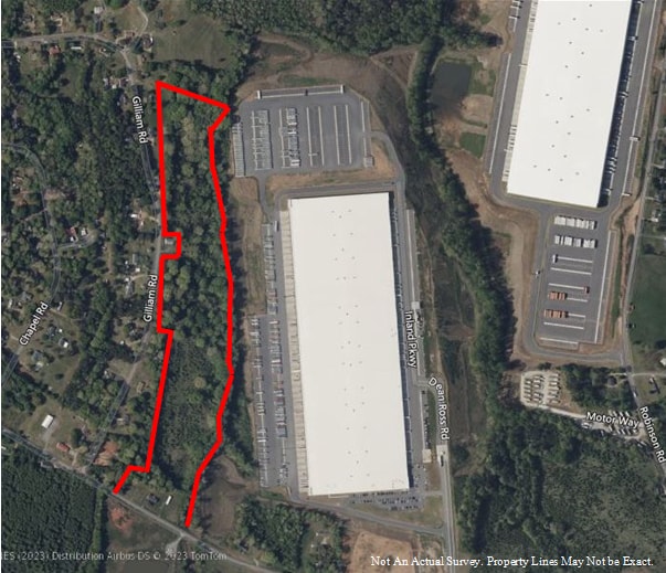
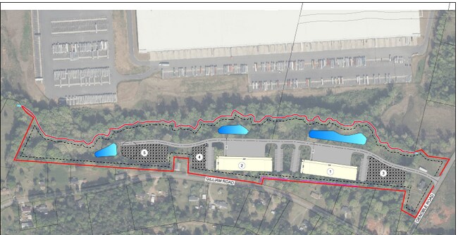
Robinson Rd
Spartanburg, SC
N SIDE GENOBLE RD E OF GILLIAM R PB 61-261 DB 32A-162 PB 145-354 DB 123N-978
5-19-00-208.00
SPARTANBURG
Commercialacreage
South Carolina
2024
70.32 AC
2025
Rt 101 Corridor
023202
Greenville/Spartanburg
NEARBY LISTINGS FOR SALE OR LEASE
DEMOGRAPHICS near Robinson Rd
1 mile
3 mile
5 mile
2025 Total Population
544
17,828
75,108
2030 Population
611
19,851
82,933
Pop Growth 2025-2030
+ 12.32%
+ 11.35%
+ 10.42%
Average Age
38
38
39
2025 Total Households
199
6,923
28,863
HH Growth 2025-2030
+ 12.56%
+ 11.38%
+ 10.43%
Median Household Inc
$48,863
$56,552
$72,245
Avg Household Size
2.70
2.50
2.60
2025 Avg HH Vehicles
2.00
2.00
2.00
Median Home Value
$225,384
$214,835
$273,302
Median Year Built
1981
1989
1998
Nearby Places
Map Layers
Map Styles
 Street
 Aerial
Layers
 Traffic
 Biking
Places
Listings with unknown addresses are not visible on the map
- Restaurants
- Banks
- Shops
- Fitness
- Groceries
PUBLIC TRANSPORTATION
AIRPORT
Greenville Spartanburg International
Drive
Walk
Distance
Greenville Spartanburg International
14 min
5.6 mi
Freight Ports
North Charleston Terminal
Drive
Walk
Distance
North Charleston Terminal
233 min
200.3 mi
SALE & LEASE HISTORY
LISTING DATE
SALE/LEASE

Jan 09, 2023
For Sale
Jan 07, 2025
For Sale
Dec 08, 2023
For Lease
Aug 07, 2019
For Sale
Nearby Properties
Address
Land Use
TOTAL SIZE
Lot Size
Zoning
Address
Land Use
TOTAL SIZE
Lot Size
Zoning
227,627 SF
21.37 AC
Address
Land Use
TOTAL SIZE
Lot Size
Zoning
241,696 SF
15.12 AC
Address
Land Use
TOTAL SIZE
Lot Size
Zoning
1,320,000 SF
130.98 AC
Address
Land Use
TOTAL SIZE
Lot Size
Zoning
Address
Land Use
TOTAL SIZE
Lot Size
Zoning
111.08 AC
Address
Land Use
TOTAL SIZE
Lot Size
Zoning
66.99 AC
Address
Land Use
TOTAL SIZE
Lot Size
Zoning
1,281 SF
41.23 AC
Address
Land Use
TOTAL SIZE
Lot Size
Zoning
710,705 SF
34.03 AC
Address
Land Use
TOTAL SIZE
Lot Size
Zoning
91,927 SF
21.14 AC
Address
Land Use
TOTAL SIZE
Lot Size
Zoning
16,592 SF
15.43 AC
Address
Land Use
TOTAL SIZE
Lot Size
Zoning
42.27 AC
Address
Land Use
TOTAL SIZE
Lot Size
Zoning
2,497 SF
12.36 AC
Address
Land Use
TOTAL SIZE
Lot Size
Zoning
1,111,000 SF
Address
Land Use
TOTAL SIZE
Lot Size
Zoning
2,088 SF
40.12 AC
Address
Land Use
TOTAL SIZE
Lot Size
Zoning
736,169 SF
24.99 AC
Address
Land Use
TOTAL SIZE
Lot Size
Zoning
15.17 AC
Address
Land Use
TOTAL SIZE
Lot Size
Zoning
33.34 AC
Address
Land Use
TOTAL SIZE
Lot Size
Zoning
33.40 AC
Address
Land Use
TOTAL SIZE
Lot Size
Zoning
1,798 SF
9.63 AC
Address
Land Use
TOTAL SIZE
Lot Size
Zoning
7,990 SF
1.62 AC
Address
Land Use
TOTAL SIZE
Lot Size
Zoning
28.26 AC
Address
Land Use
TOTAL SIZE
Lot Size
Zoning
67,938 SF
8.02 AC
Address
Land Use
TOTAL SIZE
Lot Size
Zoning
274,050 SF
Address
Land Use
TOTAL SIZE
Lot Size
Zoning
234,220 SF
Address
Land Use
TOTAL SIZE
Lot Size
Zoning
1,176 SF
20.13 AC
Address
Land Use
TOTAL SIZE
Lot Size
Zoning
107.32 AC
Address
Land Use
TOTAL SIZE
Lot Size
Zoning
217,788 SF
23.50 AC
Address
Land Use
TOTAL SIZE
Lot Size
Zoning
297,700 SF
23.64 AC
Address
Land Use
TOTAL SIZE
Lot Size
Zoning
137.18 AC
Address
Land Use
TOTAL SIZE
Lot Size
Zoning
20,621 SF
8.01 AC
The World's #1 Commercial Real Estate Marketplace
Connect with us
© 2026 CoStar Group
The information above has been obtained from sources believed reliable. While we do not doubt its accuracy we have not verified it and make no guarantee, warranty or representation about it. It is your responsibility to independently confirm its accuracy and completeness. Any projections, opinions, assumptions, or estimates used are for example only and do not represent the current or future performance of the property. The value of this transaction to you depends on tax and other factors which should be evaluated by your tax, financial, and legal advisors. You and your advisors should conduct a careful, independent investigation of the property to determine to your satisfaction the suitability of the property for your needs.