Property Record
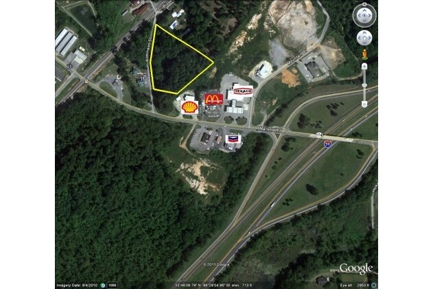
Robinson St, Springville, AL 35146

Property Detail
Robinson St
Birmingham, AL
COM INT E ROW ROBINSON ST & N ROW MARIETTA RD, TH NLY 223'S TO POB CONT NLY 475'S ALG ROBINSON ST, TH SE 553.1 SW 269.9 NW 24
13-09-31-0-012-015.000
ST CLAIR
Vacantlandnec
Alabama
B and X Area of moderate flood hazard, usually the area between the limits of the 100-year and 500-year floods.
2.70 AC
2025
St Clair County
2025
Birmingham
040503
NEARBY LISTINGS FOR SALE OR LEASE
-
-
View all Springville listings for sale on LoopNet.com
DEMOGRAPHICS near Robinson St
1 mile
3 mile
5 mile
2025 Total Population
1,790
6,634
12,696
2030 Population
1,884
6,989
13,376
Pop Growth 2025-2030
+ 5.25%
+ 5.35%
+ 5.36%
Average Age
42
42
41
2025 Total Households
679
2,468
4,656
HH Growth 2025-2030
+ 5.15%
+ 5.39%
+ 5.35%
Median Household Inc
$100,192
$99,579
$98,207
Avg Household Size
2.60
2.70
2.70
2025 Avg HH Vehicles
2.00
2.00
2.00
Median Home Value
$308,387
$293,653
$263,773
Median Year Built
2002
2000
2001
Nearby Places
Map Layers
Map Styles
 Street
 Aerial
Layers
 Traffic
 Biking
Places
Listings with unknown addresses are not visible on the map
- Restaurants
- Banks
- Shops
- Fitness
- Groceries
PUBLIC TRANSPORTATION
AIRPORT
Birmingham-Shuttlesworth International
Drive
Walk
Distance
Birmingham-Shuttlesworth International
30 min
25.1 mi
Freight Ports
Port of Mobile
Drive
Walk
Distance
Port of Mobile
305 min
280.4 mi
Nearby Properties
Address
Land Use
TOTAL SIZE
Lot Size
Zoning
Address
Land Use
TOTAL SIZE
Lot Size
Zoning
91,680 SF
8.60 AC
Address
Land Use
TOTAL SIZE
Lot Size
Zoning
16,374 SF
4.29 AC
Address
Land Use
TOTAL SIZE
Lot Size
Zoning
4,650 SF
4.17 AC
Address
Land Use
TOTAL SIZE
Lot Size
Zoning
17.20 AC
Address
Land Use
TOTAL SIZE
Lot Size
Zoning
7,538 SF
1.25 AC
Address
Land Use
TOTAL SIZE
Lot Size
Zoning
16,996 SF
3.10 AC
Address
Land Use
TOTAL SIZE
Lot Size
Zoning
2,760 SF
7.50 AC
Address
Land Use
TOTAL SIZE
Lot Size
Zoning
6,988 SF
1 AC
Address
Land Use
TOTAL SIZE
Lot Size
Zoning
3,388 SF
1.12 AC
Address
Land Use
TOTAL SIZE
Lot Size
Zoning
480 SF
0.36 AC
Address
Land Use
TOTAL SIZE
Lot Size
Zoning
1,136 SF
8.40 AC
Address
Land Use
TOTAL SIZE
Lot Size
Zoning
5,250 SF
1.66 AC
Address
Land Use
TOTAL SIZE
Lot Size
Zoning
33,050 SF
3 AC
Address
Land Use
TOTAL SIZE
Lot Size
Zoning
2,893 SF
0.89 AC
Address
Land Use
TOTAL SIZE
Lot Size
Zoning
3,807 SF
1.10 AC
Address
Land Use
TOTAL SIZE
Lot Size
Zoning
5,628 SF
1.30 AC
Address
Land Use
TOTAL SIZE
Lot Size
Zoning
6,889 SF
0.96 AC
Address
Land Use
TOTAL SIZE
Lot Size
Zoning
4,872 SF
1 AC
Address
Land Use
TOTAL SIZE
Lot Size
Zoning
3,111 SF
0.88 AC
Address
Land Use
TOTAL SIZE
Lot Size
Zoning
3,295 SF
0.70 AC
Address
Land Use
TOTAL SIZE
Lot Size
Zoning
4,651 SF
0.71 AC
Address
Land Use
TOTAL SIZE
Lot Size
Zoning
3,902 SF
2.58 AC
Address
Land Use
TOTAL SIZE
Lot Size
Zoning
3,000 SF
0.65 AC
Address
Land Use
TOTAL SIZE
Lot Size
Zoning
1,776 SF
0.80 AC
The World's #1 Commercial Real Estate Marketplace
Connect with us
© 2026 CoStar Group
The information above has been obtained from sources believed reliable. While we do not doubt its accuracy we have not verified it and make no guarantee, warranty or representation about it. It is your responsibility to independently confirm its accuracy and completeness. Any projections, opinions, assumptions, or estimates used are for example only and do not represent the current or future performance of the property. The value of this transaction to you depends on tax and other factors which should be evaluated by your tax, financial, and legal advisors. You and your advisors should conduct a careful, independent investigation of the property to determine to your satisfaction the suitability of the property for your needs.