Property Record
Rock Cut Rd, Conley, GA 30288
NEARBY LISTINGS FOR SALE OR LEASE
-
-
-
-
-
-
-
-
-
-
-
-
No Photo
-
View all Conley listings for sale on LoopNet.com
Property Detail
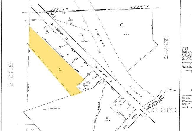
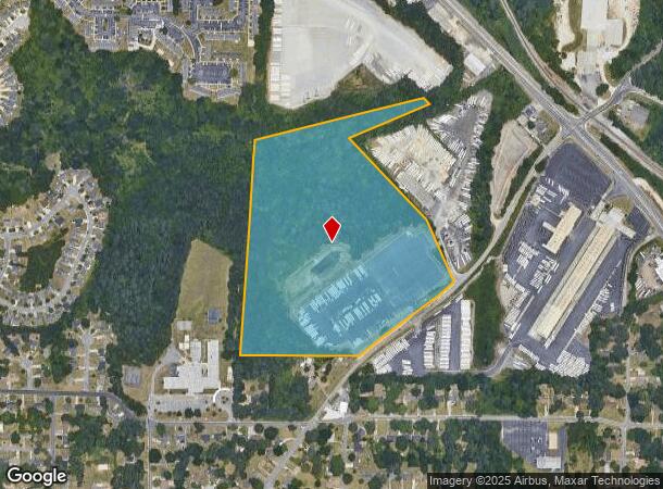
Rock Cut Rd
Atlanta-Sandy Springs-Roswell, GA
Minor Sub
12-0243C-00A-005
Clayton
Parkinglot
Georgia
AE
242
13063C0039F
30.62 AC
2024
North Clayton/Airport
2024
Atlanta
023444
DEMOGRAPHICS near Rock Cut Rd
1 Mile
3 Mile
5 Mile
2024 Total Population
5,247
39,134
147,070
2029 Population
5,170
39,373
148,782
Pop Growth 2024-2029
(1.47%)
+ 0.61%
+ 1.16%
Average Age
36
36
37
2024 Total Households
1,804
13,383
51,304
HH Growth 2024-2029
(1.44%)
+ 0.72%
+ 1.32%
Median Household Inc
$43,758
$51,162
$50,653
Avg Household Size
2.90
2.80
2.70
2024 Avg HH Vehicles
2.00
2.00
2.00
Median Home Value
$220,267
$177,395
$183,502
Median Year Built
1980
1978
1980
Nearby Places
- Restaurants
- Banks
- Shops
- Fitness
- Groceries
PUBLIC TRANSPORTATION
AIRPORT
Hartsfield - Jackson Atlanta International
DRIVE
WALK
Distance
Hartsfield - Jackson Atlanta International
16 min
6.6 mi
Freight Ports
Georgia Ports - Savannah
DRIVE
WALK
Distance
Georgia Ports - Savannah
267 min
237.8 mi
Nearby Properties
Address
Land Use
TOTAL SIZE
Lot Size
Zoning
Address
Land Use
TOTAL SIZE
Lot Size
Zoning
666,576 SF
63.38 AC
I
Address
Land Use
TOTAL SIZE
Lot Size
Zoning
873,223 SF
60.88 AC
I
Address
Land Use
TOTAL SIZE
Lot Size
Zoning
42,671 SF
56.11 AC
I
Address
Land Use
TOTAL SIZE
Lot Size
Zoning
20,964 SF
70.93 AC
I
Address
Land Use
TOTAL SIZE
Lot Size
Zoning
797,738 SF
54.98 AC
WH
Address
Land Use
TOTAL SIZE
Lot Size
Zoning
381,983 SF
52.54 AC
M
Address
Land Use
TOTAL SIZE
Lot Size
Zoning
848,420 SF
48.96 AC
I
Address
Land Use
TOTAL SIZE
Lot Size
Zoning
210,538 SF
101.40 AC
X
Address
Land Use
TOTAL SIZE
Lot Size
Zoning
381,923 SF
19.72 AC
M
Address
Land Use
TOTAL SIZE
Lot Size
Zoning
659,547 SF
31.20 AC
HI
Address
Land Use
TOTAL SIZE
Lot Size
Zoning
375,336 SF
22.76 AC
M
Address
Land Use
TOTAL SIZE
Lot Size
Zoning
59,807 SF
43.70 AC
X
Address
Land Use
TOTAL SIZE
Lot Size
Zoning
402,544 SF
20.43 AC
I1
Address
Land Use
TOTAL SIZE
Lot Size
Zoning
371,336 SF
29.50 AC
I
Address
Land Use
TOTAL SIZE
Lot Size
Zoning
321,464 SF
23.11 AC
HI
Address
Land Use
TOTAL SIZE
Lot Size
Zoning
44,365 SF
17.77 AC
M
Address
Land Use
TOTAL SIZE
Lot Size
Zoning
272,376 SF
17.73 AC
MXI
Address
Land Use
TOTAL SIZE
Lot Size
Zoning
229,829 SF
24.15 AC
HI
Address
Land Use
TOTAL SIZE
Lot Size
Zoning
365,298 SF
22.51 AC
I
Address
Land Use
TOTAL SIZE
Lot Size
Zoning
86,071 SF
18 AC
M
Address
Land Use
TOTAL SIZE
Lot Size
Zoning
332,442 SF
28.80 AC
HI
Address
Land Use
TOTAL SIZE
Lot Size
Zoning
399,000 SF
30.50 AC
WH
Address
Land Use
TOTAL SIZE
Lot Size
Zoning
343,585 SF
24.04 AC
LI
Address
Land Use
TOTAL SIZE
Lot Size
Zoning
308,683 SF
41.30 AC
C
Address
Land Use
TOTAL SIZE
Lot Size
Zoning
250 SF
13.40 AC
C
Address
Land Use
TOTAL SIZE
Lot Size
Zoning
400,000 SF
42.87 AC
HI
Address
Land Use
TOTAL SIZE
Lot Size
Zoning
169,832 SF
13.35 AC
I
Address
Land Use
TOTAL SIZE
Lot Size
Zoning
403,328 SF
31.30 AC
I1
Address
Land Use
TOTAL SIZE
Lot Size
Zoning
265.50 AC
I
Address
Land Use
TOTAL SIZE
Lot Size
Zoning
420,048 SF
27.09 AC
I1
The World's #1 Commercial Real Estate Marketplace
Connect with us
© 2025 CoStar Group
The information above has been obtained from sources believed reliable. While we do not doubt its accuracy we have not verified it and make no guarantee, warranty or representation about it. It is your responsibility to independently confirm its accuracy and completeness. Any projections, opinions, assumptions, or estimates used are for example only and do not represent the current or future performance of the property. The value of this transaction to you depends on tax and other factors which should be evaluated by your tax, financial, and legal advisors. You and your advisors should conduct a careful, independent investigation of the property to determine to your satisfaction the suitability of the property for your needs.