Property Record
3383 Rock Dr, Beavercreek, OH 45432

This Property Is For Sale
NEARBY LISTINGS FOR SALE OR LEASE
Property Detail
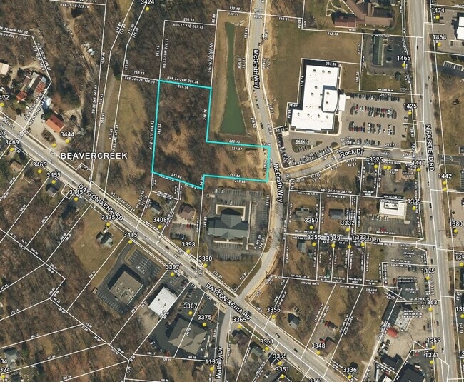
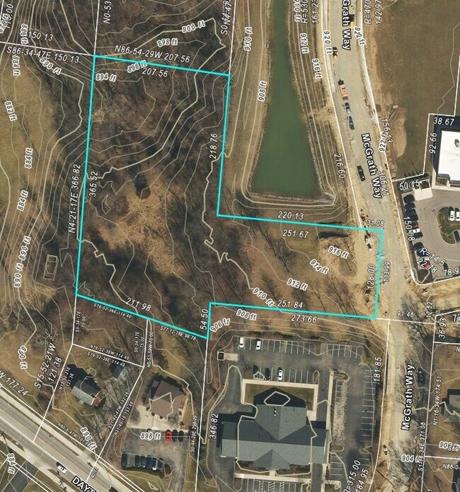
3383 Rock Dr
Dayton, OH
Warren Family Plat
B42-0005-0005-0-0137-00
WARREN FAMILY PLAT LOT 2 2.558AC ROCK DR
Commercialacreage
Greene
X
Ohio
39057C0106E
2
2024
2.56 AC
2024
East Dayton
210201
Cincinnati/Dayton
1,146 SF
DEMOGRAPHICS near 3383 Rock Dr
1 Mile
3 Mile
5 Mile
2024 Total Population
4,786
45,481
142,750
2029 Population
4,855
46,244
144,215
Pop Growth 2024-2029
+ 1.44%
+ 1.68%
+ 1.03%
Average Age
43
42
39
2024 Total Households
1,857
18,059
60,814
HH Growth 2024-2029
+ 1.40%
+ 1.62%
+ 0.95%
Median Household Inc
$105,203
$104,623
$69,611
Avg Household Size
2.50
2.50
2.30
2024 Avg HH Vehicles
2.00
2.00
2.00
Median Home Value
$199,663
$233,451
$174,357
Median Year Built
1967
1976
1967
Nearby Places
Map Layers
Map Styles
 Street
 Aerial
- Restaurants
- Banks
- Shops
- Fitness
- Groceries
PUBLIC TRANSPORTATION
AIRPORT
James M Cox Dayton International
DRIVE
WALK
Distance
James M Cox Dayton International
33 min
19.8 mi
Freight Ports
Port of Toledo
DRIVE
WALK
Distance
Port of Toledo
190 min
160.0 mi
Nearby Properties
Address
Land Use
TOTAL SIZE
Lot Size
Zoning
Address
Land Use
TOTAL SIZE
Lot Size
Zoning
259,051 SF
13.39 AC
Address
Land Use
TOTAL SIZE
Lot Size
Zoning
552,803 SF
29.77 AC
CPUD882
Address
Land Use
TOTAL SIZE
Lot Size
Zoning
752,874 SF
74.85 AC
Address
Land Use
TOTAL SIZE
Lot Size
Zoning
175,938 SF
49.33 AC
Address
Land Use
TOTAL SIZE
Lot Size
Zoning
53.48 AC
RP1
Address
Land Use
TOTAL SIZE
Lot Size
Zoning
107,570 SF
8.45 AC
Address
Land Use
TOTAL SIZE
Lot Size
Zoning
49,316 SF
30.39 AC
CPUD933
Address
Land Use
TOTAL SIZE
Lot Size
Zoning
130,247 SF
14.12 AC
Address
Land Use
TOTAL SIZE
Lot Size
Zoning
Address
Land Use
TOTAL SIZE
Lot Size
Zoning
3,243 SF
22.88 AC
R-PUD 97-3
Address
Land Use
TOTAL SIZE
Lot Size
Zoning
88,522 SF
12.96 AC
Address
Land Use
TOTAL SIZE
Lot Size
Zoning
145,500 SF
32.62 AC
A1
Address
Land Use
TOTAL SIZE
Lot Size
Zoning
46,796 SF
53.05 AC
RPUD038
Address
Land Use
TOTAL SIZE
Lot Size
Zoning
136,572 SF
5.59 AC
CPUD055
Address
Land Use
TOTAL SIZE
Lot Size
Zoning
47,424 SF
22.77 AC
RPUD917
Address
Land Use
TOTAL SIZE
Lot Size
Zoning
1,008 SF
7 AC
R1A
Address
Land Use
TOTAL SIZE
Lot Size
Zoning
27,740 SF
11.16 AC
MXPUD93
Address
Land Use
TOTAL SIZE
Lot Size
Zoning
32,852 SF
18.80 AC
C-PUD 94-4
Address
Land Use
TOTAL SIZE
Lot Size
Zoning
45,522 SF
10.22 AC
Address
Land Use
TOTAL SIZE
Lot Size
Zoning
121,392 SF
12.47 AC
Address
Land Use
TOTAL SIZE
Lot Size
Zoning
76,038 SF
12.59 AC
CPUD971
Address
Land Use
TOTAL SIZE
Lot Size
Zoning
89,176 SF
17.52 AC
Address
Land Use
TOTAL SIZE
Lot Size
Zoning
108,274 SF
25.09 AC
RPUD427
Address
Land Use
TOTAL SIZE
Lot Size
Zoning
45,954 SF
9.46 AC
Address
Land Use
TOTAL SIZE
Lot Size
Zoning
143,457 SF
19.42 AC
CPUD918
Address
Land Use
TOTAL SIZE
Lot Size
Zoning
9,216 SF
16.77 AC
RPUD891
Address
Land Use
TOTAL SIZE
Lot Size
Zoning
24,992 SF
17 AC
MULTIPLE
Address
Land Use
TOTAL SIZE
Lot Size
Zoning
20,144 SF
76.94 AC
A1
Address
Land Use
TOTAL SIZE
Lot Size
Zoning
73,040 SF
12.99 AC
RPUD901
Address
Land Use
TOTAL SIZE
Lot Size
Zoning
The World's #1 Commercial Real Estate Marketplace
Connect with us
© 2025 CoStar Group
The information above has been obtained from sources believed reliable. While we do not doubt its accuracy we have not verified it and make no guarantee, warranty or representation about it. It is your responsibility to independently confirm its accuracy and completeness. Any projections, opinions, assumptions, or estimates used are for example only and do not represent the current or future performance of the property. The value of this transaction to you depends on tax and other factors which should be evaluated by your tax, financial, and legal advisors. You and your advisors should conduct a careful, independent investigation of the property to determine to your satisfaction the suitability of the property for your needs.