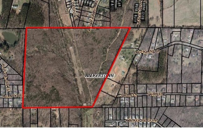
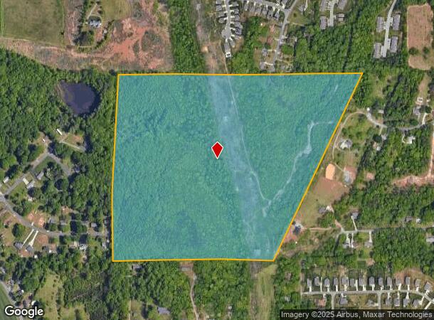
Property Record
Rocklane Dr, Walkertown, NC 27051
NEARBY LISTINGS FOR SALE OR LEASE
Property Detail
Rocklane Dr
Winston-Salem, NC
Middlefork-Two Catchall 1
6857-78-1569
LO:024 BL:3243
Residentialacreage
Forsyth
AE
North Carolina
3710685700J
24
2023
69.03 AC
2025
NE Forsyth County
002904
Greensboro/Winston-Salem
DEMOGRAPHICS near Rocklane Dr
1 Mile
3 Mile
5 Mile
2024 Total Population
2,073
19,339
61,984
2029 Population
2,166
20,105
64,703
Pop Growth 2024-2029
+ 4.49%
+ 3.96%
+ 4.39%
Average Age
42
42
40
2024 Total Households
833
7,656
24,198
HH Growth 2024-2029
+ 4.44%
+ 3.96%
+ 4.38%
Median Household Inc
$67,871
$66,160
$55,962
Avg Household Size
2.40
2.50
2.50
2024 Avg HH Vehicles
2.00
2.00
2.00
Median Home Value
$194,146
$180,352
$193,234
Median Year Built
1988
1982
1980
Nearby Places
Map Layers
Map Styles
 Street
 Aerial
- Restaurants
- Banks
- Shops
- Fitness
- Groceries
PUBLIC TRANSPORTATION
AIRPORT
Piedmont Triad International
DRIVE
WALK
Distance
Piedmont Triad International
34 min
17.9 mi
Freight Ports
Virginia Port Authority - Richmond
DRIVE
WALK
Distance
Virginia Port Authority - Richmond
260 min
221.5 mi
Nearby Properties
Address
Land Use
TOTAL SIZE
Lot Size
Zoning
Address
Land Use
TOTAL SIZE
Lot Size
Zoning
73,908 SF
14.40 AC
GB-S
Address
Land Use
TOTAL SIZE
Lot Size
Zoning
77,879 SF
9.56 AC
GB-S
Address
Land Use
TOTAL SIZE
Lot Size
Zoning
188,273 SF
54.55 AC
IP
Address
Land Use
TOTAL SIZE
Lot Size
Zoning
83,027 SF
14.47 AC
HB-S,LO-S
Address
Land Use
TOTAL SIZE
Lot Size
Zoning
98,617 SF
37.44 AC
RS20
Address
Land Use
TOTAL SIZE
Lot Size
Zoning
77,891 SF
20.91 AC
RS9
Address
Land Use
TOTAL SIZE
Lot Size
Zoning
378,330 SF
74.78 AC
GI,GI-S,RS
Address
Land Use
TOTAL SIZE
Lot Size
Zoning
113,016 SF
6.45 AC
IP
Address
Land Use
TOTAL SIZE
Lot Size
Zoning
55,106 SF
15.19 AC
IP
Address
Land Use
TOTAL SIZE
Lot Size
Zoning
11,500 SF
139.75 AC
GI,RS9
Address
Land Use
TOTAL SIZE
Lot Size
Zoning
107,609 SF
11.53 AC
HB-S
Address
Land Use
TOTAL SIZE
Lot Size
Zoning
34,104 SF
7.82 AC
RM12-S
Address
Land Use
TOTAL SIZE
Lot Size
Zoning
39,445 SF
3.49 AC
IP
Address
Land Use
TOTAL SIZE
Lot Size
Zoning
68,106 SF
18.45 AC
IP
Address
Land Use
TOTAL SIZE
Lot Size
Zoning
30,556 SF
6.40 AC
IP
Address
Land Use
TOTAL SIZE
Lot Size
Zoning
36,458 SF
7.31 AC
RS9
Address
Land Use
TOTAL SIZE
Lot Size
Zoning
22,053 SF
5.28 AC
HB-S
Address
Land Use
TOTAL SIZE
Lot Size
Zoning
6,436 SF
23.85 AC
RM8-S
Address
Land Use
TOTAL SIZE
Lot Size
Zoning
66,636 SF
14.81 AC
IP
Address
Land Use
TOTAL SIZE
Lot Size
Zoning
41,743 SF
8.51 AC
RM18-S
Address
Land Use
TOTAL SIZE
Lot Size
Zoning
48,400 SF
8.59 AC
HB-S
Address
Land Use
TOTAL SIZE
Lot Size
Zoning
40,714 SF
10.50 AC
IP
Address
Land Use
TOTAL SIZE
Lot Size
Zoning
31,290 SF
9.76 AC
IP,RS9
Address
Land Use
TOTAL SIZE
Lot Size
Zoning
13,101 SF
1.73 AC
HB-S
Address
Land Use
TOTAL SIZE
Lot Size
Zoning
14,424 SF
1.88 AC
HB,LB,RS20
Address
Land Use
TOTAL SIZE
Lot Size
Zoning
18,076 SF
3.60 AC
RS20
Address
Land Use
TOTAL SIZE
Lot Size
Zoning
10,079 SF
2.89 AC
IP
Address
Land Use
TOTAL SIZE
Lot Size
Zoning
15,702 SF
2.55 AC
LB-S
Address
Land Use
TOTAL SIZE
Lot Size
Zoning
24,355 SF
11.32 AC
GI
Address
Land Use
TOTAL SIZE
Lot Size
Zoning
30,435 SF
7.04 AC
HB
The World's #1 Commercial Real Estate Marketplace
Connect with us
© 2025 CoStar Group
The information above has been obtained from sources believed reliable. While we do not doubt its accuracy we have not verified it and make no guarantee, warranty or representation about it. It is your responsibility to independently confirm its accuracy and completeness. Any projections, opinions, assumptions, or estimates used are for example only and do not represent the current or future performance of the property. The value of this transaction to you depends on tax and other factors which should be evaluated by your tax, financial, and legal advisors. You and your advisors should conduct a careful, independent investigation of the property to determine to your satisfaction the suitability of the property for your needs.