Property Record
Rockmart Hwy, , GA

This Property Is For Sale
Property Detail
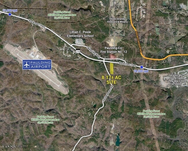
Rockmart Hwy
Atlanta-Sandy Springs-Roswell, GA
REAL PROPERTY
133.3.2.005.0000
PAULDING
Taxexempt
Georgia
B2
319
B and X Area of moderate flood hazard, usually the area between the limits of the 100-year and 500-year floods.
8.17 AC
0
Kennesaw/Town Center
2025
Atlanta
120401
NEARBY LISTINGS FOR SALE OR LEASE
DEMOGRAPHICS near Rockmart Hwy
1 mile
3 mile
5 mile
2024 Total Population
401
4,886
21,963
2029 Population
460
5,636
25,225
Pop Growth 2024-2029
+ 14.71%
+ 15.35%
+ 14.85%
Average Age
38
38
37
2024 Total Households
143
1,657
7,687
HH Growth 2024-2029
+ 14.69%
+ 15.45%
+ 14.90%
Median Household Inc
$64,322
$69,607
$67,707
Avg Household Size
2.80
2.90
2.80
2024 Avg HH Vehicles
2.00
2.00
2.00
Median Home Value
$152,409
$203,852
$188,265
Median Year Built
2003
2002
1999
Nearby Places
Map Layers
Map Styles
 Street
 Aerial
Transit
 Traffic
 Biking
Places
Listings with unknown addresses are not visible on the map
- Restaurants
- Banks
- Shops
- Fitness
- Groceries
Nearby Properties
Address
Land Use
TOTAL SIZE
Lot Size
Zoning
Address
Land Use
TOTAL SIZE
Lot Size
Zoning
36.60 AC
Address
Land Use
TOTAL SIZE
Lot Size
Zoning
55,000 SF
7.01 AC
Address
Land Use
TOTAL SIZE
Lot Size
Zoning
49 AC
H1-59;R3-4
Address
Land Use
TOTAL SIZE
Lot Size
Zoning
12,600 SF
18.96 AC
B1
Address
Land Use
TOTAL SIZE
Lot Size
Zoning
23,922 SF
10.13 AC
Address
Land Use
TOTAL SIZE
Lot Size
Zoning
22,480 SF
2 AC
C2
Address
Land Use
TOTAL SIZE
Lot Size
Zoning
11,200 SF
5.98 AC
Address
Land Use
TOTAL SIZE
Lot Size
Zoning
12,330 SF
5 AC
I2
Address
Land Use
TOTAL SIZE
Lot Size
Zoning
Address
Land Use
TOTAL SIZE
Lot Size
Zoning
2.75 AC
Address
Land Use
TOTAL SIZE
Lot Size
Zoning
19,500 SF
1.50 AC
B1-0
Address
Land Use
TOTAL SIZE
Lot Size
Zoning
2,196 SF
128.68 AC
Address
Land Use
TOTAL SIZE
Lot Size
Zoning
112.27 AC
Address
Land Use
TOTAL SIZE
Lot Size
Zoning
103.44 AC
Address
Land Use
TOTAL SIZE
Lot Size
Zoning
19,638 SF
0.84 AC
Address
Land Use
TOTAL SIZE
Lot Size
Zoning
988 SF
106.32 AC
Address
Land Use
TOTAL SIZE
Lot Size
Zoning
3,652 SF
11.38 AC
Address
Land Use
TOTAL SIZE
Lot Size
Zoning
22.56 AC
I2
Address
Land Use
TOTAL SIZE
Lot Size
Zoning
900 SF
157.50 AC
Address
Land Use
TOTAL SIZE
Lot Size
Zoning
6,000 SF
4.36 AC
C2
Address
Land Use
TOTAL SIZE
Lot Size
Zoning
3,000 SF
1.50 AC
Address
Land Use
TOTAL SIZE
Lot Size
Zoning
85.75 AC
Address
Land Use
TOTAL SIZE
Lot Size
Zoning
11,600 SF
1.94 AC
B2
Address
Land Use
TOTAL SIZE
Lot Size
Zoning
110.30 AC
.95-100
Address
Land Use
TOTAL SIZE
Lot Size
Zoning
6,976 SF
2.62 AC
Address
Land Use
TOTAL SIZE
Lot Size
Zoning
5,064 SF
10.35 AC
Address
Land Use
TOTAL SIZE
Lot Size
Zoning
83.06 AC
Address
Land Use
TOTAL SIZE
Lot Size
Zoning
107.19 AC
Address
Land Use
TOTAL SIZE
Lot Size
Zoning
3,696 SF
96.68 AC
The World's #1 Commercial Real Estate Marketplace
Connect with us
© 2026 CoStar Group
The information above has been obtained from sources believed reliable. While we do not doubt its accuracy we have not verified it and make no guarantee, warranty or representation about it. It is your responsibility to independently confirm its accuracy and completeness. Any projections, opinions, assumptions, or estimates used are for example only and do not represent the current or future performance of the property. The value of this transaction to you depends on tax and other factors which should be evaluated by your tax, financial, and legal advisors. You and your advisors should conduct a careful, independent investigation of the property to determine to your satisfaction the suitability of the property for your needs.