Property Record
Industrial, Rockwall, TX 75087

Property Detail
Industrial
Dallas-Fort Worth-Arlington, TX
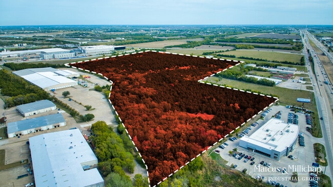
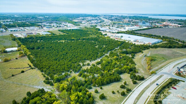
A0099 A HANNA, TRACT 3, ACRES 37.487
10994
ROCKWALL
Commercialacreage
Texas
AE The base floodplain where base flood elevations are provided. AE Zones are now used on new format FIRMs instead of A1-A30 Zones.
37.49 AC
2024
Rockwall
2025
Dallas/Ft Worth
040202
NEARBY LISTINGS FOR SALE OR LEASE
-
-
-
Rockwall - I-30 & John King Blvd - NEQ - CU - News
Rockwall, TX 75087
Rent Upon Request
19.78 AC Lots
Land
-
-
-
-
-
View all Rockwall listings for sale on LoopNet.com
DEMOGRAPHICS near Industrial
1 mile
3 mile
5 mile
2025 Total Population
3,793
49,674
112,604
2030 Population
4,560
59,515
134,155
Pop Growth 2025-2030
+ 20.22%
+ 19.81%
+ 19.14%
Average Age
41
38
38
2025 Total Households
1,723
17,429
38,308
HH Growth 2025-2030
+ 20.49%
+ 19.69%
+ 19.05%
Median Household Inc
$82,722
$98,213
$110,785
Avg Household Size
2.00
2.80
2.90
2025 Avg HH Vehicles
2.00
2.00
2.00
Median Home Value
$437,899
$386,952
$396,531
Median Year Built
2010
2005
2006
Nearby Places
Map Layers
Map Styles
 Street
 Aerial
Transit
 Traffic
 Biking
Places
Listings with unknown addresses are not visible on the map
- Restaurants
- Banks
- Shops
- Fitness
- Groceries
PUBLIC TRANSPORTATION
AIRPORT
Dallas Love Field
Drive
Walk
Distance
Dallas Love Field
42 min
28.5 mi
Freight Ports
Port of Shreveport
Drive
Walk
Distance
Port of Shreveport
205 min
184.4 mi
SALE & LEASE HISTORY
LISTING DATE
SALE/LEASE

Nov 07, 2023
For Sale
Nov 07, 2023
For Sale
Nearby Properties
Address
Land Use
TOTAL SIZE
Lot Size
Zoning
Address
Land Use
TOTAL SIZE
Lot Size
Zoning
326,761 SF
23.09 AC
Address
Land Use
TOTAL SIZE
Lot Size
Zoning
193,393 SF
69.53 AC
Address
Land Use
TOTAL SIZE
Lot Size
Zoning
193,393 SF
80 AC
Address
Land Use
TOTAL SIZE
Lot Size
Zoning
44,191 SF
32.66 AC
Address
Land Use
TOTAL SIZE
Lot Size
Zoning
326,842 SF
21.28 AC
Address
Land Use
TOTAL SIZE
Lot Size
Zoning
288,677 SF
41.65 AC
P11
Address
Land Use
TOTAL SIZE
Lot Size
Zoning
311,294 SF
21.28 AC
Address
Land Use
TOTAL SIZE
Lot Size
Zoning
238,085 SF
34.49 AC
Address
Land Use
TOTAL SIZE
Lot Size
Zoning
413,908 SF
35.30 AC
Address
Land Use
TOTAL SIZE
Lot Size
Zoning
282,628 SF
4.03 AC
Address
Land Use
TOTAL SIZE
Lot Size
Zoning
656,340 SF
34.23 AC
Address
Land Use
TOTAL SIZE
Lot Size
Zoning
157,834 SF
30.89 AC
Address
Land Use
TOTAL SIZE
Lot Size
Zoning
214,166 SF
21.42 AC
Address
Land Use
TOTAL SIZE
Lot Size
Zoning
198,270 SF
21.48 AC
Address
Land Use
TOTAL SIZE
Lot Size
Zoning
250,627 SF
18.17 AC
Address
Land Use
TOTAL SIZE
Lot Size
Zoning
153,541 SF
27.44 AC
Address
Land Use
TOTAL SIZE
Lot Size
Zoning
77,891 SF
11.61 AC
A
Address
Land Use
TOTAL SIZE
Lot Size
Zoning
391,599 SF
30.04 AC
Address
Land Use
TOTAL SIZE
Lot Size
Zoning
242,845 SF
16.01 AC
Address
Land Use
TOTAL SIZE
Lot Size
Zoning
227,296 SF
2.14 AC
Address
Land Use
TOTAL SIZE
Lot Size
Zoning
126,341 SF
18.41 AC
L1
Address
Land Use
TOTAL SIZE
Lot Size
Zoning
211,790 SF
11.58 AC
MF1
Address
Land Use
TOTAL SIZE
Lot Size
Zoning
245,501 SF
6.65 AC
Address
Land Use
TOTAL SIZE
Lot Size
Zoning
353,525 SF
42.99 AC
Address
Land Use
TOTAL SIZE
Lot Size
Zoning
85,912 SF
5.93 AC
Address
Land Use
TOTAL SIZE
Lot Size
Zoning
174,826 SF
11.13 AC
Address
Land Use
TOTAL SIZE
Lot Size
Zoning
191,568 SF
10.31 AC
Address
Land Use
TOTAL SIZE
Lot Size
Zoning
223,664 SF
3.80 AC
Address
Land Use
TOTAL SIZE
Lot Size
Zoning
108,429 SF
2.06 AC
Address
Land Use
TOTAL SIZE
Lot Size
Zoning
99,800 SF
10.10 AC
C
The World's #1 Commercial Real Estate Marketplace
Connect with us
© 2026 CoStar Group
The information above has been obtained from sources believed reliable. While we do not doubt its accuracy we have not verified it and make no guarantee, warranty or representation about it. It is your responsibility to independently confirm its accuracy and completeness. Any projections, opinions, assumptions, or estimates used are for example only and do not represent the current or future performance of the property. The value of this transaction to you depends on tax and other factors which should be evaluated by your tax, financial, and legal advisors. You and your advisors should conduct a careful, independent investigation of the property to determine to your satisfaction the suitability of the property for your needs.