Property Record
Roney Rd, Dothan, AL 36303
NEARBY LISTINGS FOR SALE OR LEASE
Property Detail
Roney Rd
Dothan, AL
Bermuda Village
10-03-06-2-001-014-003
LOT 1 BERMUDA VILLAGE SUB
Restaurantdrivein
Houston
2025
Alabama
2025
1
040301
Dothan/Enterprise
2,827 SF
Other Market Areas
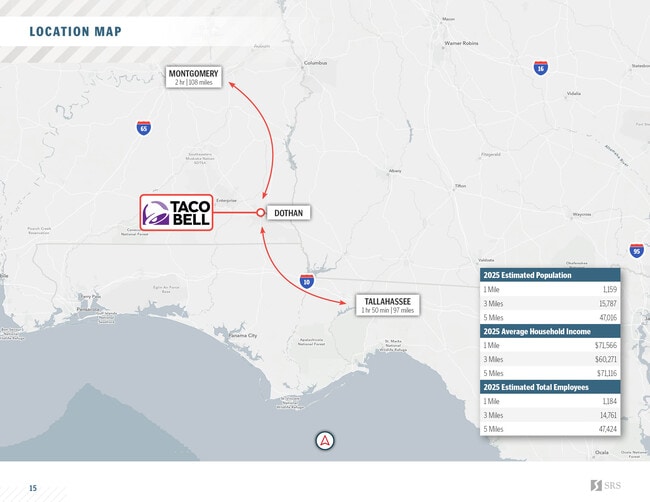
DEMOGRAPHICS near Roney Rd
1 mile
3 mile
5 mile
2024 Total Population
989
16,065
45,696
2029 Population
1,005
16,402
46,124
Pop Growth 2024-2029
+ 1.62%
+ 2.10%
+ 0.94%
Average Age
44
39
40
2024 Total Households
397
6,802
19,194
HH Growth 2024-2029
+ 1.76%
+ 2.28%
+ 1.00%
Median Household Inc
$44,124
$40,197
$44,510
Avg Household Size
2.40
2.30
2.30
2024 Avg HH Vehicles
2.00
2.00
2.00
Median Home Value
$162,643
$135,790
$158,831
Median Year Built
1974
1974
1974
Nearby Places
Map Layers
Map Styles
 Street
 Aerial
Transit
 Traffic
 Biking
Places
Listings with unknown addresses are not visible on the map
- Restaurants
- Banks
- Shops
- Fitness
- Groceries
PUBLIC TRANSPORTATION
AIRPORT
Dothan Regional
Drive
Walk
Distance
Dothan Regional
15 min
8.7 mi
Freight Ports
Port of Panama City
Drive
Walk
Distance
Port of Panama City
117 min
88.6 mi
SALE & LEASE HISTORY
LISTING DATE
SALE/LEASE

Oct 10, 2025
For Sale
Nearby Properties
Address
Land Use
TOTAL SIZE
Lot Size
Zoning
Address
Land Use
TOTAL SIZE
Lot Size
Zoning
201,250 SF
Address
Land Use
TOTAL SIZE
Lot Size
Zoning
101,500 SF
Address
Land Use
TOTAL SIZE
Lot Size
Zoning
5,389 SF
15.62 AC
Address
Land Use
TOTAL SIZE
Lot Size
Zoning
88,725 SF
17 AC
Address
Land Use
TOTAL SIZE
Lot Size
Zoning
34,399 SF
17.70 AC
Address
Land Use
TOTAL SIZE
Lot Size
Zoning
173,138 SF
8.50 AC
Address
Land Use
TOTAL SIZE
Lot Size
Zoning
9,526 SF
14.66 AC
Address
Land Use
TOTAL SIZE
Lot Size
Zoning
201,923 SF
33.52 AC
Address
Land Use
TOTAL SIZE
Lot Size
Zoning
175,728 SF
10.11 AC
Address
Land Use
TOTAL SIZE
Lot Size
Zoning
39,223 SF
12.03 AC
Address
Land Use
TOTAL SIZE
Lot Size
Zoning
1,980 SF
18.31 AC
Address
Land Use
TOTAL SIZE
Lot Size
Zoning
17,420 SF
8 AC
Address
Land Use
TOTAL SIZE
Lot Size
Zoning
42,982 SF
1.24 AC
Address
Land Use
TOTAL SIZE
Lot Size
Zoning
96,422 SF
7.92 AC
Address
Land Use
TOTAL SIZE
Lot Size
Zoning
315,188 SF
32 AC
Address
Land Use
TOTAL SIZE
Lot Size
Zoning
52,402 SF
0.27 AC
Address
Land Use
TOTAL SIZE
Lot Size
Zoning
201,288 SF
13.82 AC
Address
Land Use
TOTAL SIZE
Lot Size
Zoning
150,000 SF
7.50 AC
Address
Land Use
TOTAL SIZE
Lot Size
Zoning
10,358 SF
26.56 AC
Address
Land Use
TOTAL SIZE
Lot Size
Zoning
6,930 SF
5.88 AC
Address
Land Use
TOTAL SIZE
Lot Size
Zoning
49,544 SF
11.02 AC
Address
Land Use
TOTAL SIZE
Lot Size
Zoning
240,000 SF
16.92 AC
Address
Land Use
TOTAL SIZE
Lot Size
Zoning
2,255 SF
15.17 AC
Address
Land Use
TOTAL SIZE
Lot Size
Zoning
56,514 SF
Address
Land Use
TOTAL SIZE
Lot Size
Zoning
1,787 SF
19.10 AC
Address
Land Use
TOTAL SIZE
Lot Size
Zoning
114,000 SF
2.50 AC
Address
Land Use
TOTAL SIZE
Lot Size
Zoning
2,500 SF
16 AC
Address
Land Use
TOTAL SIZE
Lot Size
Zoning
21,232 SF
1.33 AC
Address
Land Use
TOTAL SIZE
Lot Size
Zoning
4,972 SF
12.40 AC
Address
Land Use
TOTAL SIZE
Lot Size
Zoning
85,260 SF
4.09 AC
The World's #1 Commercial Real Estate Marketplace
Connect with us
© 2026 CoStar Group
The information above has been obtained from sources believed reliable. While we do not doubt its accuracy we have not verified it and make no guarantee, warranty or representation about it. It is your responsibility to independently confirm its accuracy and completeness. Any projections, opinions, assumptions, or estimates used are for example only and do not represent the current or future performance of the property. The value of this transaction to you depends on tax and other factors which should be evaluated by your tax, financial, and legal advisors. You and your advisors should conduct a careful, independent investigation of the property to determine to your satisfaction the suitability of the property for your needs.