Property Record
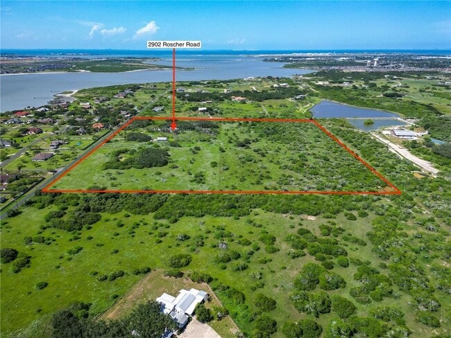
Roscher Rd Caribbean Dr, Corpus Christi, TX 78418

Property Detail
Roscher Rd Caribbean Dr
Corpus Christi, TX
FLOUR BLUFF & ENC FRM GDN TRACT 5.804 ACS OUT OF LT 17 SEC 39
232382
NUECES
Farms
Texas
R1B
17
B and X Area of moderate flood hazard, usually the area between the limits of the 100-year and 500-year floods.
34.20 AC
2024
Flour Bluff/Padre Island
2025
Corpus Christi
003102
NEARBY LISTINGS FOR SALE OR LEASE
DEMOGRAPHICS near Roscher Rd Caribbean Dr
1 mile
3 mile
5 mile
2025 Total Population
813
44,327
110,842
2030 Population
841
44,274
110,122
Pop Growth 2025-2030
+ 3.44%
(0.12%)
(0.65%)
Average Age
39
37
37
2025 Total Households
269
16,265
41,585
HH Growth 2025-2030
+ 3.35%
(0.52%)
(0.98%)
Median Household Inc
$135,949
$95,848
$77,291
Avg Household Size
3.00
2.60
2.50
2025 Avg HH Vehicles
2.00
2.00
2.00
Median Home Value
$450,000
$267,679
$256,513
Median Year Built
2006
2001
1993
Nearby Places
Map Layers
Map Styles
 Street
 Aerial
Layers
 Traffic
 Biking
Places
Listings with unknown addresses are not visible on the map
- Restaurants
- Banks
- Shops
- Fitness
- Groceries
PUBLIC TRANSPORTATION
AIRPORT
Corpus Christi International
Drive
Walk
Distance
Corpus Christi International
31 min
18.4 mi
Freight Ports
Port of Corpus Christi
Drive
Walk
Distance
Port of Corpus Christi
26 min
14.2 mi
SALE & LEASE HISTORY
LISTING DATE
SALE/LEASE

Jan 22, 2025
For Sale
Nearby Properties
Address
Land Use
TOTAL SIZE
Lot Size
Zoning
Address
Land Use
TOTAL SIZE
Lot Size
Zoning
754,977 SF
93 AC
VII
Address
Land Use
TOTAL SIZE
Lot Size
Zoning
248,852 SF
50.64 AC
Address
Land Use
TOTAL SIZE
Lot Size
Zoning
380,000 SF
71.08 AC
Address
Land Use
TOTAL SIZE
Lot Size
Zoning
257,979 SF
40.14 AC
Address
Land Use
TOTAL SIZE
Lot Size
Zoning
196,076 SF
13.25 AC
Address
Land Use
TOTAL SIZE
Lot Size
Zoning
2,884 SF
621 AC
R-1B
Address
Land Use
TOTAL SIZE
Lot Size
Zoning
96,546 SF
19.99 AC
Address
Land Use
TOTAL SIZE
Lot Size
Zoning
97,799 SF
8.35 AC
Address
Land Use
TOTAL SIZE
Lot Size
Zoning
60,829 SF
44.79 AC
Address
Land Use
TOTAL SIZE
Lot Size
Zoning
108,694 SF
30.97 AC
Address
Land Use
TOTAL SIZE
Lot Size
Zoning
9,202 SF
126.97 AC
R1B
Address
Land Use
TOTAL SIZE
Lot Size
Zoning
72,555 SF
10 AC
R1C
Address
Land Use
TOTAL SIZE
Lot Size
Zoning
158,613 SF
17.15 AC
Address
Land Use
TOTAL SIZE
Lot Size
Zoning
32,204 SF
5.52 AC
Address
Land Use
TOTAL SIZE
Lot Size
Zoning
1,911 SF
3.86 AC
Address
Land Use
TOTAL SIZE
Lot Size
Zoning
1,632 SF
4.31 AC
B-1
Address
Land Use
TOTAL SIZE
Lot Size
Zoning
33,038 SF
9.70 AC
Address
Land Use
TOTAL SIZE
Lot Size
Zoning
58,500 SF
3.06 AC
B-3
Address
Land Use
TOTAL SIZE
Lot Size
Zoning
41,400 SF
5.33 AC
B4
Address
Land Use
TOTAL SIZE
Lot Size
Zoning
2,560 SF
4.15 AC
Address
Land Use
TOTAL SIZE
Lot Size
Zoning
2,400 SF
4.38 AC
I-2
Address
Land Use
TOTAL SIZE
Lot Size
Zoning
Address
Land Use
TOTAL SIZE
Lot Size
Zoning
37,592 SF
5.60 AC
B-4
Address
Land Use
TOTAL SIZE
Lot Size
Zoning
6,186 SF
11.85 AC
T-1B
Address
Land Use
TOTAL SIZE
Lot Size
Zoning
54,100 SF
4.45 AC
B4
Address
Land Use
TOTAL SIZE
Lot Size
Zoning
25,852 SF
10 AC
R1B
Address
Land Use
TOTAL SIZE
Lot Size
Zoning
1,802 SF
5.69 AC
B-4
Address
Land Use
TOTAL SIZE
Lot Size
Zoning
1,200 SF
2.87 AC
I2
Address
Land Use
TOTAL SIZE
Lot Size
Zoning
24,168 SF
6 AC
FR
Address
Land Use
TOTAL SIZE
Lot Size
Zoning
55,261 SF
1.82 AC
B-3
The World's #1 Commercial Real Estate Marketplace
Connect with us
© 2026 CoStar Group
The information above has been obtained from sources believed reliable. While we do not doubt its accuracy we have not verified it and make no guarantee, warranty or representation about it. It is your responsibility to independently confirm its accuracy and completeness. Any projections, opinions, assumptions, or estimates used are for example only and do not represent the current or future performance of the property. The value of this transaction to you depends on tax and other factors which should be evaluated by your tax, financial, and legal advisors. You and your advisors should conduct a careful, independent investigation of the property to determine to your satisfaction the suitability of the property for your needs.