Property Record
Roseville Rd, North Highlands, CA 95660
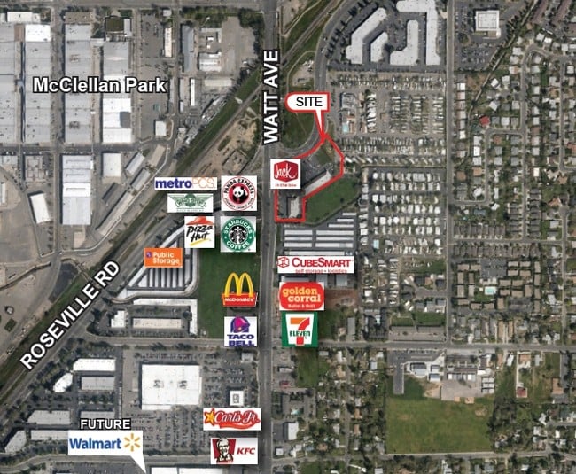


This Property Is For Sale
NEARBY LISTINGS FOR SALE OR LEASE
Property Detail
Roseville Rd
Sacramento--Roseville--Arden-Arcade, CA
Parcel Map
228-0251-052
PARCEL MAP, LOT 3
Storebuilding
Sacramento
AE
California
06067C0067H
3
2024
0.34 AC
2025
Rio Linda/N Highlands
007402
Sacramento
20,060 SF
DEMOGRAPHICS near Roseville Rd
1 Mile
3 Mile
5 Mile
2024 Total Population
13,251
121,312
382,302
2029 Population
13,337
121,747
383,712
Pop Growth 2024-2029
+ 0.65%
+ 0.36%
+ 0.37%
Average Age
35
38
38
2024 Total Households
4,240
42,933
135,735
HH Growth 2024-2029
+ 0.68%
+ 0.31%
+ 0.33%
Median Household Inc
$49,560
$59,352
$67,757
Avg Household Size
2.90
2.70
2.70
2024 Avg HH Vehicles
2.00
2.00
2.00
Median Home Value
$248,660
$375,601
$415,131
Median Year Built
1974
1970
1973
Nearby Places
Map Layers
Map Styles
 Street
 Aerial
- Restaurants
- Banks
- Shops
- Fitness
- Groceries
PUBLIC TRANSPORTATION
COMMUTER RAIL
DRIVE
WALK
Distance
17 min
9.0 mi
AIRPORT
Sacramento International
DRIVE
WALK
Distance
Sacramento International
25 min
16.6 mi
Nearby Properties
Address
Land Use
TOTAL SIZE
Lot Size
Zoning
Address
Land Use
TOTAL SIZE
Lot Size
Zoning
512,630 SF
37.68 AC
SPA (NPA)
Address
Land Use
TOTAL SIZE
Lot Size
Zoning
224,595 SF
42.03 AC
SPA
Address
Land Use
TOTAL SIZE
Lot Size
Zoning
43,200 SF
38.55 AC
SPA
Address
Land Use
TOTAL SIZE
Lot Size
Zoning
430,406 SF
24.45 AC
RD-20
Address
Land Use
TOTAL SIZE
Lot Size
Zoning
152,000 SF
12.88 AC
SPA
Address
Land Use
TOTAL SIZE
Lot Size
Zoning
145,334 SF
8.84 AC
RD-20
Address
Land Use
TOTAL SIZE
Lot Size
Zoning
417,214 SF
23.66 AC
SPA
Address
Land Use
TOTAL SIZE
Lot Size
Zoning
15.83 AC
MRD-SPD
Address
Land Use
TOTAL SIZE
Lot Size
Zoning
75,700 SF
4.02 AC
RD-40
Address
Land Use
TOTAL SIZE
Lot Size
Zoning
170,556 SF
8.41 AC
SPA
Address
Land Use
TOTAL SIZE
Lot Size
Zoning
1,221,441 SF
36.86 AC
SPA
Address
Land Use
TOTAL SIZE
Lot Size
Zoning
217,380 SF
10 AC
SPA
Address
Land Use
TOTAL SIZE
Lot Size
Zoning
136,483 SF
3.77 AC
BP
Address
Land Use
TOTAL SIZE
Lot Size
Zoning
263,792 SF
7.27 AC
SPA
Address
Land Use
TOTAL SIZE
Lot Size
Zoning
130,507 SF
8.97 AC
RD-20
Address
Land Use
TOTAL SIZE
Lot Size
Zoning
146,283 SF
8.73 AC
RD-20
Address
Land Use
TOTAL SIZE
Lot Size
Zoning
123,622 SF
5.93 AC
RD-20
Address
Land Use
TOTAL SIZE
Lot Size
Zoning
148,576 SF
4.84 AC
RD-30
Address
Land Use
TOTAL SIZE
Lot Size
Zoning
9.81 AC
SPA
Address
Land Use
TOTAL SIZE
Lot Size
Zoning
280,864 SF
14.94 AC
RD-20
Address
Land Use
TOTAL SIZE
Lot Size
Zoning
43,183 SF
12.35 AC
H F
Address
Land Use
TOTAL SIZE
Lot Size
Zoning
72,119 SF
2.38 AC
BP (NPA)
Address
Land Use
TOTAL SIZE
Lot Size
Zoning
Address
Land Use
TOTAL SIZE
Lot Size
Zoning
1,484 SF
4.94 AC
RD-20
Address
Land Use
TOTAL SIZE
Lot Size
Zoning
100,529 SF
13.65 AC
RD-10 BP
Address
Land Use
TOTAL SIZE
Lot Size
Zoning
117,288 SF
6.14 AC
M-1S-R
Address
Land Use
TOTAL SIZE
Lot Size
Zoning
106,437 SF
4.73 AC
RD-30
Address
Land Use
TOTAL SIZE
Lot Size
Zoning
100,462 SF
5.02 AC
RD-30
Address
Land Use
TOTAL SIZE
Lot Size
Zoning
164,000 SF
8.32 AC
SPA
Address
Land Use
TOTAL SIZE
Lot Size
Zoning
89,613 SF
4.48 AC
SPA
The World's #1 Commercial Real Estate Marketplace
Connect with us
© 2025 CoStar Group
The information above has been obtained from sources believed reliable. While we do not doubt its accuracy we have not verified it and make no guarantee, warranty or representation about it. It is your responsibility to independently confirm its accuracy and completeness. Any projections, opinions, assumptions, or estimates used are for example only and do not represent the current or future performance of the property. The value of this transaction to you depends on tax and other factors which should be evaluated by your tax, financial, and legal advisors. You and your advisors should conduct a careful, independent investigation of the property to determine to your satisfaction the suitability of the property for your needs.