Property Record
Ross Clark Cir, Dothan, AL 36301

Save to a Folder
{{folder.Name}}
{{folder.ListingIds.length}} Properties
{{folder.ListingIds.length}} Property
Create a New Folder
Property Detail
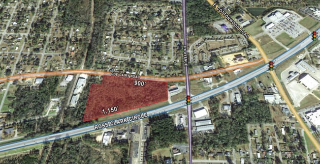
Ross Clark Cir
Dothan, AL
LOC IN SW1/4 OF NW1/4 OF SEC 31 T3N R27E BEG @ INT OF N R/W OF ROSS CLARK CIR & W LN OF SEC TH N 568.16' E 167.11' N 216 .42'
10-09-31-2-001-012-000
HOUSTON
Vacantlandnec
Alabama
AE The base floodplain where base flood elevations are provided. AE Zones are now used on new format FIRMs instead of A1-A30 Zones.
12.99 AC
2025
Dothan/Enterprise
2025
Other Market Areas
041100
NEARBY LISTINGS FOR SALE OR LEASE
DEMOGRAPHICS near Ross Clark Cir
1 mile
3 mile
5 mile
2025 Total Population
5,918
33,067
56,062
2030 Population
5,987
33,685
57,033
Pop Growth 2025-2030
+ 1.17%
+ 1.87%
+ 1.73%
Average Age
40
39
40
2025 Total Households
2,492
13,670
23,513
HH Growth 2025-2030
+ 1.24%
+ 1.91%
+ 1.75%
Median Household Inc
$44,644
$41,666
$50,330
Avg Household Size
2.30
2.30
2.30
2025 Avg HH Vehicles
2.00
2.00
2.00
Median Home Value
$136,435
$150,404
$174,610
Median Year Built
1975
1975
1977
Nearby Places
Map Layers
Map Styles
 Street
 Aerial
Layers
 Traffic
 Biking
Places
Listings with unknown addresses are not visible on the map
- Restaurants
- Banks
- Shops
- Fitness
- Groceries
PUBLIC TRANSPORTATION
AIRPORT
Dothan Regional
Drive
Walk
Distance
Dothan Regional
20 min
11.8 mi
Freight Ports
Port of Panama City
Drive
Walk
Distance
Port of Panama City
110 min
84.4 mi
SALE & LEASE HISTORY
LISTING DATE
SALE/LEASE

Sep 24, 2016
For Sale
Nearby Properties
Address
Land Use
TOTAL SIZE
Lot Size
Zoning
Address
Land Use
TOTAL SIZE
Lot Size
Zoning
3,955 SF
19.20 AC
Address
Land Use
TOTAL SIZE
Lot Size
Zoning
1,800 SF
21.49 AC
Address
Land Use
TOTAL SIZE
Lot Size
Zoning
7,198 SF
Address
Land Use
TOTAL SIZE
Lot Size
Zoning
628 SF
22.30 AC
Address
Land Use
TOTAL SIZE
Lot Size
Zoning
39,500 SF
1.97 AC
Address
Land Use
TOTAL SIZE
Lot Size
Zoning
88,725 SF
17 AC
Address
Land Use
TOTAL SIZE
Lot Size
Zoning
7,749 SF
17.70 AC
Address
Land Use
TOTAL SIZE
Lot Size
Zoning
900 SF
38 AC
Address
Land Use
TOTAL SIZE
Lot Size
Zoning
828 SF
14.30 AC
Address
Land Use
TOTAL SIZE
Lot Size
Zoning
323 SF
60 AC
Address
Land Use
TOTAL SIZE
Lot Size
Zoning
3,213 SF
12.66 AC
Address
Land Use
TOTAL SIZE
Lot Size
Zoning
244,027 SF
Address
Land Use
TOTAL SIZE
Lot Size
Zoning
53,736 SF
9.20 AC
Address
Land Use
TOTAL SIZE
Lot Size
Zoning
460 SF
3.90 AC
Address
Land Use
TOTAL SIZE
Lot Size
Zoning
52,270 SF
3.84 AC
Address
Land Use
TOTAL SIZE
Lot Size
Zoning
90,918 SF
0.88 AC
Address
Land Use
TOTAL SIZE
Lot Size
Zoning
1,700 SF
3.49 AC
Address
Land Use
TOTAL SIZE
Lot Size
Zoning
25,300 SF
1.24 AC
Address
Land Use
TOTAL SIZE
Lot Size
Zoning
19,239 SF
16 AC
Address
Land Use
TOTAL SIZE
Lot Size
Zoning
72,200 SF
2.89 AC
Address
Land Use
TOTAL SIZE
Lot Size
Zoning
24,352 SF
5.34 AC
Address
Land Use
TOTAL SIZE
Lot Size
Zoning
35,850 SF
30 AC
Address
Land Use
TOTAL SIZE
Lot Size
Zoning
176 SF
8.46 AC
Address
Land Use
TOTAL SIZE
Lot Size
Zoning
360 SF
32 AC
Address
Land Use
TOTAL SIZE
Lot Size
Zoning
83,068 SF
3.84 AC
Address
Land Use
TOTAL SIZE
Lot Size
Zoning
120,000 SF
18 AC
Address
Land Use
TOTAL SIZE
Lot Size
Zoning
15,000 SF
5.26 AC
Address
Land Use
TOTAL SIZE
Lot Size
Zoning
175,000 SF
5.13 AC
Address
Land Use
TOTAL SIZE
Lot Size
Zoning
180 SF
3.65 AC
Address
Land Use
TOTAL SIZE
Lot Size
Zoning
69,000 SF
6.53 AC
The World's #1 Commercial Real Estate Marketplace
Connect with us
© 2026 CoStar Group
The information above has been obtained from sources believed reliable. While we do not doubt its accuracy we have not verified it and make no guarantee, warranty or representation about it. It is your responsibility to independently confirm its accuracy and completeness. Any projections, opinions, assumptions, or estimates used are for example only and do not represent the current or future performance of the property. The value of this transaction to you depends on tax and other factors which should be evaluated by your tax, financial, and legal advisors. You and your advisors should conduct a careful, independent investigation of the property to determine to your satisfaction the suitability of the property for your needs.