Property Record
Ross Rd, Fairfield, OH 45014
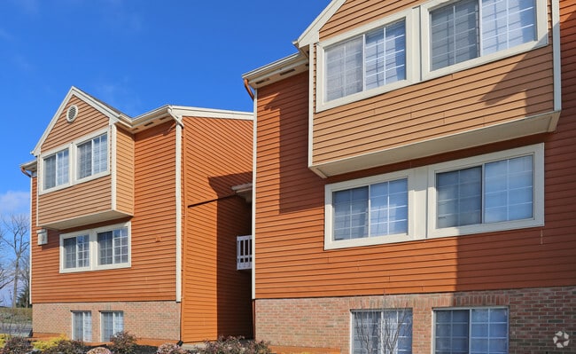
Property Detail
Ross Rd
Cincinnati, OH-KY-IN
9553 ENT 13.927
A0700-017-000-072
BUTLER
Apartment
Ohio
B and X Area of moderate flood hazard, usually the area between the limits of the 100-year and 500-year floods.
9553
2024
0.62 AC
2025
Butler County
010912
Cincinnati/Dayton
NEARBY LISTINGS FOR SALE OR LEASE
-
-
View all Fairfield listings for sale on LoopNet.com
DEMOGRAPHICS near Ross Rd
1 mile
3 mile
5 mile
2025 Total Population
11,001
60,518
157,356
2030 Population
11,455
61,696
160,375
Pop Growth 2025-2030
+ 4.13%
+ 1.95%
+ 1.92%
Average Age
39
40
40
2025 Total Households
4,906
24,052
61,640
HH Growth 2025-2030
+ 4.30%
+ 2.12%
+ 2.01%
Median Household Inc
$68,594
$71,559
$73,489
Avg Household Size
2.20
2.40
2.50
2025 Avg HH Vehicles
2.00
2.00
2.00
Median Home Value
$213,216
$215,598
$228,968
Median Year Built
1981
1976
1976
Nearby Places
Map Layers
Map Styles
 Street
 Aerial
Transit
 Traffic
 Biking
Places
Listings with unknown addresses are not visible on the map
- Restaurants
- Banks
- Shops
- Fitness
- Groceries
PUBLIC TRANSPORTATION
AIRPORT
Cincinnati/Northern Kentucky International
Drive
Walk
Distance
Cincinnati/Northern Kentucky International
57 min
35.2 mi
Freight Ports
Port of Toledo
Drive
Walk
Distance
Port of Toledo
228 min
192.9 mi
Nearby Properties
Address
Land Use
TOTAL SIZE
Lot Size
Zoning
Address
Land Use
TOTAL SIZE
Lot Size
Zoning
61.62 AC
Address
Land Use
TOTAL SIZE
Lot Size
Zoning
38,880 SF
20.93 AC
Address
Land Use
TOTAL SIZE
Lot Size
Zoning
28.80 AC
Address
Land Use
TOTAL SIZE
Lot Size
Zoning
34.60 AC
Address
Land Use
TOTAL SIZE
Lot Size
Zoning
1,363,493 SF
75.28 AC
Address
Land Use
TOTAL SIZE
Lot Size
Zoning
559,332 SF
29.30 AC
Address
Land Use
TOTAL SIZE
Lot Size
Zoning
706,768 SF
35.92 AC
Address
Land Use
TOTAL SIZE
Lot Size
Zoning
914,426 SF
41.39 AC
Address
Land Use
TOTAL SIZE
Lot Size
Zoning
782,765 SF
33.15 AC
Address
Land Use
TOTAL SIZE
Lot Size
Zoning
510,080 SF
60.87 AC
Address
Land Use
TOTAL SIZE
Lot Size
Zoning
18.77 AC
Address
Land Use
TOTAL SIZE
Lot Size
Zoning
334,887 SF
16.16 AC
Address
Land Use
TOTAL SIZE
Lot Size
Zoning
26.63 AC
Address
Land Use
TOTAL SIZE
Lot Size
Zoning
39.89 AC
Address
Land Use
TOTAL SIZE
Lot Size
Zoning
467,263 SF
27.27 AC
ADV
Address
Land Use
TOTAL SIZE
Lot Size
Zoning
54.77 AC
Address
Land Use
TOTAL SIZE
Lot Size
Zoning
350,772 SF
23.62 AC
Address
Land Use
TOTAL SIZE
Lot Size
Zoning
32,372 SF
32.90 AC
Address
Land Use
TOTAL SIZE
Lot Size
Zoning
567,230 SF
31.45 AC
Address
Land Use
TOTAL SIZE
Lot Size
Zoning
115,446 SF
20.08 AC
Address
Land Use
TOTAL SIZE
Lot Size
Zoning
2.24 AC
Address
Land Use
TOTAL SIZE
Lot Size
Zoning
438,182 SF
28.80 AC
Address
Land Use
TOTAL SIZE
Lot Size
Zoning
629,044 SF
35.83 AC
Address
Land Use
TOTAL SIZE
Lot Size
Zoning
25.89 AC
Address
Land Use
TOTAL SIZE
Lot Size
Zoning
482,499 SF
27.83 AC
Address
Land Use
TOTAL SIZE
Lot Size
Zoning
4,849 SF
19.98 AC
Address
Land Use
TOTAL SIZE
Lot Size
Zoning
1,700 SF
35.39 AC
Address
Land Use
TOTAL SIZE
Lot Size
Zoning
319,568 SF
23.73 AC
Address
Land Use
TOTAL SIZE
Lot Size
Zoning
111,993 SF
17.34 AC
Address
Land Use
TOTAL SIZE
Lot Size
Zoning
357,452 SF
26.77 AC
The World's #1 Commercial Real Estate Marketplace
Connect with us
© 2026 CoStar Group
The information above has been obtained from sources believed reliable. While we do not doubt its accuracy we have not verified it and make no guarantee, warranty or representation about it. It is your responsibility to independently confirm its accuracy and completeness. Any projections, opinions, assumptions, or estimates used are for example only and do not represent the current or future performance of the property. The value of this transaction to you depends on tax and other factors which should be evaluated by your tax, financial, and legal advisors. You and your advisors should conduct a careful, independent investigation of the property to determine to your satisfaction the suitability of the property for your needs.