Property Record
Route 1, Bel Air, MD 21014

NEARBY LISTINGS FOR SALE OR LEASE
Property Detail
Route 1
Baltimore-Columbia-Towson, MD
S E S Us Rt 1
03-052575
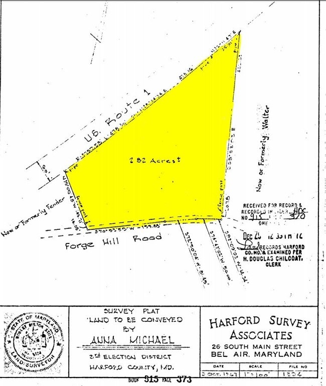
LOT 2.82 AC S E S US RT #1 E OF FORGE HILL RD
Commercialacreage
Harford
X
Maryland
24025C0160E
2.82 AC
2025
Outlying Harford County
2025
Baltimore
303801
DEMOGRAPHICS near Route 1
1 Mile
3 Mile
5 Mile
2024 Total Population
699
7,060
50,772
2029 Population
715
7,234
52,090
Pop Growth 2024-2029
+ 2.29%
+ 2.46%
+ 2.60%
Average Age
44
42
42
2024 Total Households
263
2,499
18,757
HH Growth 2024-2029
+ 2.28%
+ 2.56%
+ 2.68%
Median Household Inc
$75,266
$108,520
$104,089
Avg Household Size
2.70
2.80
2.60
2024 Avg HH Vehicles
3.00
2.00
2.00
Median Home Value
$297,190
$376,432
$368,371
Median Year Built
1967
1984
1988
Nearby Places
Map Layers
Map Styles
 Street
 Aerial
- Restaurants
- Banks
- Shops
- Fitness
- Groceries
PUBLIC TRANSPORTATION
AIRPORT
Baltimore/Washington International Thurgood Marshall
DRIVE
WALK
Distance
Baltimore/Washington International Thurgood Marshall
63 min
43.1 mi
Freight Ports
Port Newark Container Terminal
DRIVE
WALK
Distance
Port Newark Container Terminal
47 min
30.3 mi
SALE & LEASE HISTORY
LISTING DATE
SALE/LEASE

Aug 09, 2017
For Sale
Nearby Properties
Address
Land Use
TOTAL SIZE
Lot Size
Zoning
Address
Land Use
TOTAL SIZE
Lot Size
Zoning
73,217.90 AC
Address
Land Use
TOTAL SIZE
Lot Size
Zoning
51,475 SF
7.85 AC
C1
Address
Land Use
TOTAL SIZE
Lot Size
Zoning
78,264 SF
16.71 AC
AG
Address
Land Use
TOTAL SIZE
Lot Size
Zoning
77,649 SF
10.42 AC
GI
Address
Land Use
TOTAL SIZE
Lot Size
Zoning
52,530 SF
5.60 AC
B3
Address
Land Use
TOTAL SIZE
Lot Size
Zoning
67,606 SF
23.04 AC
AG
Address
Land Use
TOTAL SIZE
Lot Size
Zoning
2,943 SF
10.30 AC
B3
Address
Land Use
TOTAL SIZE
Lot Size
Zoning
4,736 SF
1.18 AC
CI
Address
Land Use
TOTAL SIZE
Lot Size
Zoning
46.96 AC
AG
Address
Land Use
TOTAL SIZE
Lot Size
Zoning
13,917 SF
48.72 AC
CI
Address
Land Use
TOTAL SIZE
Lot Size
Zoning
14,640 SF
22.41 AC
CI
Address
Land Use
TOTAL SIZE
Lot Size
Zoning
16,000 SF
3.94 AC
CI
Address
Land Use
TOTAL SIZE
Lot Size
Zoning
8,662 SF
54.16 AC
B3
Address
Land Use
TOTAL SIZE
Lot Size
Zoning
16,271 SF
31.97 AC
AG
Address
Land Use
TOTAL SIZE
Lot Size
Zoning
12,178 SF
98 AC
GI/AG
Address
Land Use
TOTAL SIZE
Lot Size
Zoning
10,610 SF
1.25 AC
CI
Address
Land Use
TOTAL SIZE
Lot Size
Zoning
1,960 SF
0.50 AC
B3
Address
Land Use
TOTAL SIZE
Lot Size
Zoning
6,982 SF
1.36 AC
B3
Address
Land Use
TOTAL SIZE
Lot Size
Zoning
2,934 SF
0.84 AC
B3
Address
Land Use
TOTAL SIZE
Lot Size
Zoning
3.38 AC
CI
Address
Land Use
TOTAL SIZE
Lot Size
Zoning
14,340 SF
4.56 AC
AG B3
Address
Land Use
TOTAL SIZE
Lot Size
Zoning
4,881 SF
1.77 AC
CI
Address
Land Use
TOTAL SIZE
Lot Size
Zoning
2,800 SF
3.19 AC
B3
Address
Land Use
TOTAL SIZE
Lot Size
Zoning
320.12 AC
AG
Address
Land Use
TOTAL SIZE
Lot Size
Zoning
15,632 SF
2.18 AC
GI
Address
Land Use
TOTAL SIZE
Lot Size
Zoning
7,500 SF
1.38 AC
CI
Address
Land Use
TOTAL SIZE
Lot Size
Zoning
1.45 AC
AG
Address
Land Use
TOTAL SIZE
Lot Size
Zoning
8,160 SF
1.98 AC
GI
Address
Land Use
TOTAL SIZE
Lot Size
Zoning
2,466 SF
1.92 AC
B3
Address
Land Use
TOTAL SIZE
Lot Size
Zoning
1,402 SF
1.49 AC
B3
The World's #1 Commercial Real Estate Marketplace
Connect with us
© 2026 CoStar Group
The information above has been obtained from sources believed reliable. While we do not doubt its accuracy we have not verified it and make no guarantee, warranty or representation about it. It is your responsibility to independently confirm its accuracy and completeness. Any projections, opinions, assumptions, or estimates used are for example only and do not represent the current or future performance of the property. The value of this transaction to you depends on tax and other factors which should be evaluated by your tax, financial, and legal advisors. You and your advisors should conduct a careful, independent investigation of the property to determine to your satisfaction the suitability of the property for your needs.