Property Record
Route 101, Bedford, NH 03110
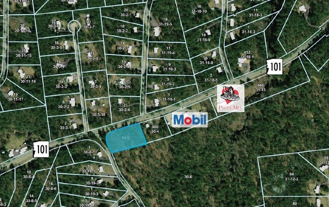
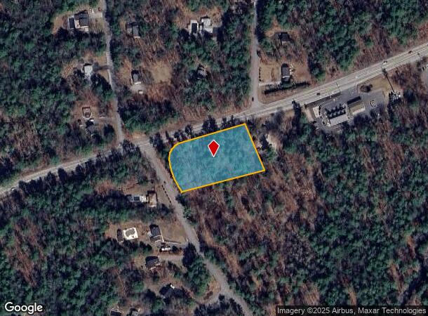
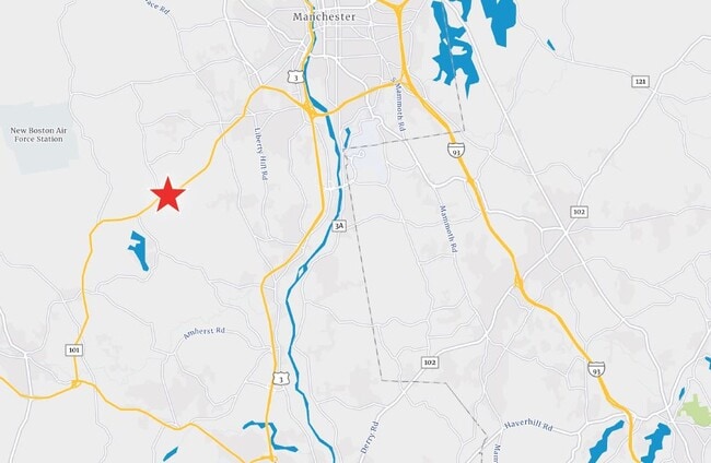
This Property Is For Sale
NEARBY LISTINGS FOR SALE OR LEASE
Property Detail
Route 101
BEDD M:30 B:5 L:
Hillsborough
Commercialacreage
New Hampshire
X
1.50 AC
33011C0366D
Hillsborough
2024
Boston
2024
Manchester-Nashua, NH
002901
DEMOGRAPHICS near Route 101
1 Mile
3 Mile
5 Mile
2024 Total Population
2,010
15,273
45,911
2029 Population
2,051
15,640
47,148
Pop Growth 2024-2029
+ 2.04%
+ 2.40%
+ 2.69%
Average Age
40
41
42
2024 Total Households
642
5,001
16,174
HH Growth 2024-2029
+ 2.02%
+ 2.42%
+ 2.72%
Median Household Inc
$182,618
$160,982
$136,588
Avg Household Size
3.10
3.00
2.80
2024 Avg HH Vehicles
2.00
2.00
2.00
Median Home Value
$588,773
$532,600
$455,286
Median Year Built
1984
1986
1984
Nearby Places
Map Layers
Map Styles
 Street
 Aerial
- Restaurants
- Banks
- Shops
- Fitness
- Groceries
PUBLIC TRANSPORTATION
AIRPORT
Manchester Boston Regional
DRIVE
WALK
Distance
Manchester Boston Regional
20 min
10.1 mi
Freight Ports
Port of Boston
DRIVE
WALK
Distance
Port of Boston
90 min
63.9 mi
Nearby Properties
Address
Land Use
TOTAL SIZE
Lot Size
Zoning
Address
Land Use
TOTAL SIZE
Lot Size
Zoning
347,230 SF
42.11 AC
RA
Address
Land Use
TOTAL SIZE
Lot Size
Zoning
134,115 SF
64.40 AC
RESIDE
Address
Land Use
TOTAL SIZE
Lot Size
Zoning
137,515 SF
IN
Address
Land Use
TOTAL SIZE
Lot Size
Zoning
39,504 SF
2.52 AC
Address
Land Use
TOTAL SIZE
Lot Size
Zoning
18,204 SF
55.70 AC
RA
Address
Land Use
TOTAL SIZE
Lot Size
Zoning
35,752 SF
6.47 AC
CO
Address
Land Use
TOTAL SIZE
Lot Size
Zoning
0.51 AC
CO
Address
Land Use
TOTAL SIZE
Lot Size
Zoning
26,595 SF
11.70 AC
CO
Address
Land Use
TOTAL SIZE
Lot Size
Zoning
9,631 SF
11.25 AC
RR
Address
Land Use
TOTAL SIZE
Lot Size
Zoning
14,011 SF
10.01 AC
CO
Address
Land Use
TOTAL SIZE
Lot Size
Zoning
17,655 SF
Address
Land Use
TOTAL SIZE
Lot Size
Zoning
13,126 SF
138.60 AC
RESIDE
Address
Land Use
TOTAL SIZE
Lot Size
Zoning
13,682 SF
1.40 AC
CO
Address
Land Use
TOTAL SIZE
Lot Size
Zoning
11,726 SF
4.31 AC
CO
Address
Land Use
TOTAL SIZE
Lot Size
Zoning
3,000 SF
29.57 AC
RA
Address
Land Use
TOTAL SIZE
Lot Size
Zoning
7,824 SF
37.34 AC
RR
Address
Land Use
TOTAL SIZE
Lot Size
Zoning
19,835 SF
14.80 AC
NT
Address
Land Use
TOTAL SIZE
Lot Size
Zoning
2,240 SF
4.70 AC
C
Address
Land Use
TOTAL SIZE
Lot Size
Zoning
1,340 SF
13.08 AC
RR
Address
Land Use
TOTAL SIZE
Lot Size
Zoning
15,000 SF
1.90 AC
CO
Address
Land Use
TOTAL SIZE
Lot Size
Zoning
16,730 SF
5.04 AC
CO
Address
Land Use
TOTAL SIZE
Lot Size
Zoning
0.88 AC
RA
Address
Land Use
TOTAL SIZE
Lot Size
Zoning
13.65 AC
RA
Address
Land Use
TOTAL SIZE
Lot Size
Zoning
1.85 AC
RA
Address
Land Use
TOTAL SIZE
Lot Size
Zoning
8,796 SF
5.55 AC
RA
Address
Land Use
TOTAL SIZE
Lot Size
Zoning
29.98 AC
RA
Address
Land Use
TOTAL SIZE
Lot Size
Zoning
3,690 SF
2 AC
HC
Address
Land Use
TOTAL SIZE
Lot Size
Zoning
16,660 SF
11.31 AC
RA
Address
Land Use
TOTAL SIZE
Lot Size
Zoning
9,360 SF
1.73 AC
CO
Address
Land Use
TOTAL SIZE
Lot Size
Zoning
3,340 SF
0.79 AC
RA
The World's #1 Commercial Real Estate Marketplace
Connect with us
© 2026 CoStar Group
The information above has been obtained from sources believed reliable. While we do not doubt its accuracy we have not verified it and make no guarantee, warranty or representation about it. It is your responsibility to independently confirm its accuracy and completeness. Any projections, opinions, assumptions, or estimates used are for example only and do not represent the current or future performance of the property. The value of this transaction to you depends on tax and other factors which should be evaluated by your tax, financial, and legal advisors. You and your advisors should conduct a careful, independent investigation of the property to determine to your satisfaction the suitability of the property for your needs.