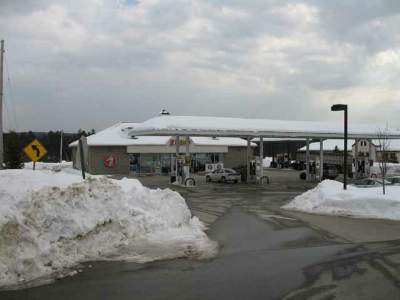
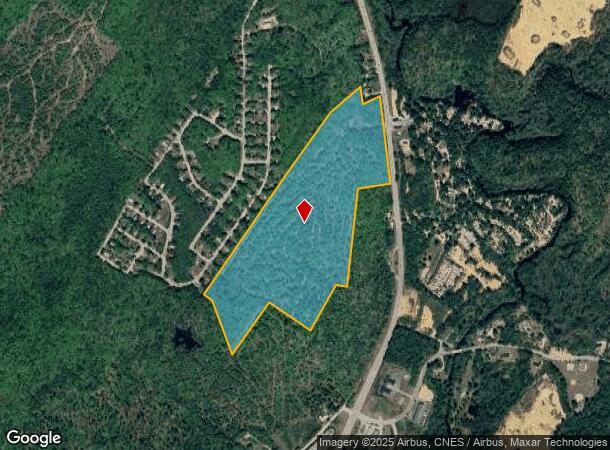
Property Record
Route 106 S, Loudon, NH 03307
NEARBY LISTINGS FOR SALE OR LEASE
Property Detail
Route 106 S
LOUD-000020-000072
Merrimack
Multipleuses
New Hampshire
X
77.80 AC
33013C0365E
Concord/New Hampshire North Area
2024
Other Market Areas
2024
Concord, NH
036000
DEMOGRAPHICS near Route 106 S
1 Mile
3 Mile
5 Mile
2024 Total Population
1,216
4,706
18,263
2029 Population
1,292
4,985
19,201
Pop Growth 2024-2029
+ 6.25%
+ 5.93%
+ 5.14%
Average Age
46
44
44
2024 Total Households
497
1,826
7,508
HH Growth 2024-2029
+ 6.04%
+ 5.75%
+ 4.94%
Median Household Inc
$42,941
$81,878
$79,286
Avg Household Size
2.40
2.60
2.40
2024 Avg HH Vehicles
2.00
2.00
2.00
Median Home Value
$307,692
$326,953
$328,193
Median Year Built
1994
1988
1983
Nearby Places
Map Layers
Map Styles
 Street
 Aerial
- Restaurants
- Banks
- Shops
- Fitness
- Groceries
PUBLIC TRANSPORTATION
AIRPORT
Manchester Boston Regional
DRIVE
WALK
Distance
Manchester Boston Regional
50 min
31.3 mi
Freight Ports
Portland, ME
DRIVE
WALK
Distance
Portland, ME
129 min
82.6 mi
Nearby Properties
Address
Land Use
TOTAL SIZE
Lot Size
Zoning
Address
Land Use
TOTAL SIZE
Lot Size
Zoning
41.49 AC
CG
Address
Land Use
TOTAL SIZE
Lot Size
Zoning
194,386 SF
33.30 AC
GWP
Address
Land Use
TOTAL SIZE
Lot Size
Zoning
50.19 AC
GWP
Address
Land Use
TOTAL SIZE
Lot Size
Zoning
135,161 SF
36.20 AC
GWP
Address
Land Use
TOTAL SIZE
Lot Size
Zoning
65,868 SF
10.60 AC
GWP
Address
Land Use
TOTAL SIZE
Lot Size
Zoning
AGRICU
Address
Land Use
TOTAL SIZE
Lot Size
Zoning
8.58 AC
GWP
Address
Land Use
TOTAL SIZE
Lot Size
Zoning
44,963 SF
16.29 AC
COMM V
Address
Land Use
TOTAL SIZE
Lot Size
Zoning
3.47 AC
GWP
Address
Land Use
TOTAL SIZE
Lot Size
Zoning
67,678 SF
7 AC
VILLLA
Address
Land Use
TOTAL SIZE
Lot Size
Zoning
30,580 SF
5.39 AC
GWP
Address
Land Use
TOTAL SIZE
Lot Size
Zoning
1,520 SF
143.90 AC
C/ICOM
Address
Land Use
TOTAL SIZE
Lot Size
Zoning
27,944 SF
9.11 AC
GWP
Address
Land Use
TOTAL SIZE
Lot Size
Zoning
24,096 SF
2.61 AC
GWP
Address
Land Use
TOTAL SIZE
Lot Size
Zoning
35,230 SF
18.40 AC
C/ICOM
Address
Land Use
TOTAL SIZE
Lot Size
Zoning
19,200 SF
2.87 AC
GWP
Address
Land Use
TOTAL SIZE
Lot Size
Zoning
2.35 AC
GWP
Address
Land Use
TOTAL SIZE
Lot Size
Zoning
11.07 AC
RM
Address
Land Use
TOTAL SIZE
Lot Size
Zoning
2,556 SF
167.37 AC
C-1D
Address
Land Use
TOTAL SIZE
Lot Size
Zoning
19,098 SF
5.06 AC
COMM/I
Address
Land Use
TOTAL SIZE
Lot Size
Zoning
17,600 SF
3.26 AC
ARR -
Address
Land Use
TOTAL SIZE
Lot Size
Zoning
384 SF
41.74 AC
C-1D
Address
Land Use
TOTAL SIZE
Lot Size
Zoning
49,099 SF
6.31 AC
GWP
Address
Land Use
TOTAL SIZE
Lot Size
Zoning
31,554 SF
8.11 AC
VILLLA
Address
Land Use
TOTAL SIZE
Lot Size
Zoning
11,985 SF
11.40 AC
RM
Address
Land Use
TOTAL SIZE
Lot Size
Zoning
8,309 SF
1.35 AC
GWP
Address
Land Use
TOTAL SIZE
Lot Size
Zoning
5,012 SF
1.01 AC
GWP
Address
Land Use
TOTAL SIZE
Lot Size
Zoning
5,116 SF
2.64 AC
GWP
Address
Land Use
TOTAL SIZE
Lot Size
Zoning
8,337 SF
4.16 AC
C/ICOM
Address
Land Use
TOTAL SIZE
Lot Size
Zoning
2,078 SF
21.47 AC
RURAL
The World's #1 Commercial Real Estate Marketplace
Connect with us
© 2025 CoStar Group
The information above has been obtained from sources believed reliable. While we do not doubt its accuracy we have not verified it and make no guarantee, warranty or representation about it. It is your responsibility to independently confirm its accuracy and completeness. Any projections, opinions, assumptions, or estimates used are for example only and do not represent the current or future performance of the property. The value of this transaction to you depends on tax and other factors which should be evaluated by your tax, financial, and legal advisors. You and your advisors should conduct a careful, independent investigation of the property to determine to your satisfaction the suitability of the property for your needs.