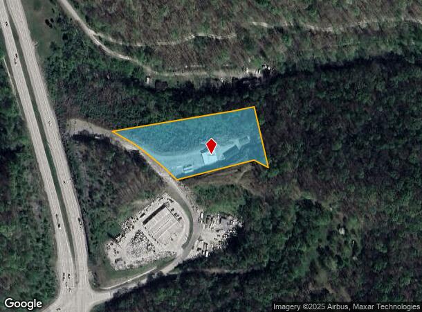
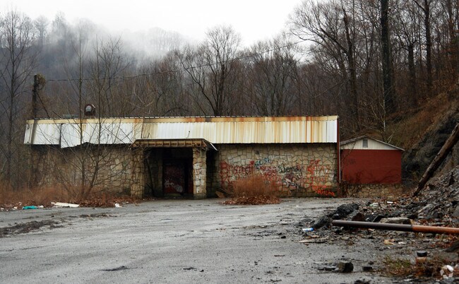
Property Record
Route 119, Danville, WV 25053

NEARBY LISTINGS FOR SALE OR LEASE
-
-
View all Danville listings for sale on LoopNet.com
Property Detail
Route 119
05-23-00570000
3 SF.,2 TRACTS,BRAD PRICE BR.
Bartavern
Boone
X
West Virginia
54005C0130D
3 AC
2025
Boone County
2025
Charleston WV
958400
Charleston, WV
DEMOGRAPHICS near Route 119
1 Mile
3 Mile
5 Mile
2024 Total Population
402
4,496
8,387
2029 Population
385
4,338
8,088
Pop Growth 2024-2029
(4.23%)
(3.51%)
(3.57%)
Average Age
44
43
44
2024 Total Households
165
1,875
3,471
HH Growth 2024-2029
(3.03%)
(2.93%)
(3.00%)
Median Household Inc
$57,333
$55,087
$55,249
Avg Household Size
2.40
2.40
2.40
2024 Avg HH Vehicles
2.00
2.00
2.00
Median Home Value
$96,969
$116,295
$108,234
Median Year Built
1982
1975
1977
Nearby Places
Map Layers
Map Styles
 Street
 Aerial
- Restaurants
- Banks
- Shops
- Fitness
- Groceries
PUBLIC TRANSPORTATION
AIRPORT
West Virginia International Yeager
DRIVE
WALK
Distance
West Virginia International Yeager
47 min
34.7 mi
Nearby Properties
Address
Land Use
TOTAL SIZE
Lot Size
Zoning
Address
Land Use
TOTAL SIZE
Lot Size
Zoning
Address
Land Use
TOTAL SIZE
Lot Size
Zoning
6.71 AC
Address
Land Use
TOTAL SIZE
Lot Size
Zoning
0.87 AC
Address
Land Use
TOTAL SIZE
Lot Size
Zoning
2.66 AC
Address
Land Use
TOTAL SIZE
Lot Size
Zoning
0.23 AC
Address
Land Use
TOTAL SIZE
Lot Size
Zoning
Address
Land Use
TOTAL SIZE
Lot Size
Zoning
0.32 AC
Address
Land Use
TOTAL SIZE
Lot Size
Zoning
0.57 AC
Address
Land Use
TOTAL SIZE
Lot Size
Zoning
10.45 AC
Address
Land Use
TOTAL SIZE
Lot Size
Zoning
0.52 AC
Address
Land Use
TOTAL SIZE
Lot Size
Zoning
17.42 AC
Address
Land Use
TOTAL SIZE
Lot Size
Zoning
5.03 AC
Address
Land Use
TOTAL SIZE
Lot Size
Zoning
2.69 AC
Address
Land Use
TOTAL SIZE
Lot Size
Zoning
Address
Land Use
TOTAL SIZE
Lot Size
Zoning
2.84 AC
Address
Land Use
TOTAL SIZE
Lot Size
Zoning
3.55 AC
Address
Land Use
TOTAL SIZE
Lot Size
Zoning
0.69 AC
Address
Land Use
TOTAL SIZE
Lot Size
Zoning
Address
Land Use
TOTAL SIZE
Lot Size
Zoning
Address
Land Use
TOTAL SIZE
Lot Size
Zoning
9.65 AC
Address
Land Use
TOTAL SIZE
Lot Size
Zoning
0.44 AC
Address
Land Use
TOTAL SIZE
Lot Size
Zoning
3.11 AC
Address
Land Use
TOTAL SIZE
Lot Size
Zoning
3.05 AC
Address
Land Use
TOTAL SIZE
Lot Size
Zoning
0.57 AC
Address
Land Use
TOTAL SIZE
Lot Size
Zoning
2,856 SF
6.10 AC
Address
Land Use
TOTAL SIZE
Lot Size
Zoning
0.56 AC
Address
Land Use
TOTAL SIZE
Lot Size
Zoning
0.51 AC
Address
Land Use
TOTAL SIZE
Lot Size
Zoning
Address
Land Use
TOTAL SIZE
Lot Size
Zoning
0.21 AC
Address
Land Use
TOTAL SIZE
Lot Size
Zoning
0.28 AC
The World's #1 Commercial Real Estate Marketplace
Connect with us
© 2026 CoStar Group
The information above has been obtained from sources believed reliable. While we do not doubt its accuracy we have not verified it and make no guarantee, warranty or representation about it. It is your responsibility to independently confirm its accuracy and completeness. Any projections, opinions, assumptions, or estimates used are for example only and do not represent the current or future performance of the property. The value of this transaction to you depends on tax and other factors which should be evaluated by your tax, financial, and legal advisors. You and your advisors should conduct a careful, independent investigation of the property to determine to your satisfaction the suitability of the property for your needs.