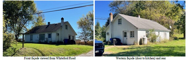
Property Record
Route 136, Whiteford, MD 21160


NEARBY LISTINGS FOR SALE OR LEASE
Property Detail
Route 136
05-036887
LOT 0.519 ACRE SW RT 136 NEAR HEAPS ROAD
Taxexempt
Harford
X
Maryland
24025C0055E
0.52 AC
0
Outlying Harford County
2025
Baltimore
305100
Baltimore-Columbia-Towson, MD
DEMOGRAPHICS near Route 136
1 mile
3 mile
5 mile
2024 Total Population
522
5,869
12,805
2029 Population
533
6,003
13,095
Pop Growth 2024-2029
+ 2.11%
+ 2.28%
+ 2.26%
Average Age
43
43
43
2024 Total Households
189
2,145
4,716
HH Growth 2024-2029
+ 2.12%
+ 2.28%
+ 2.27%
Median Household Inc
$101,389
$94,327
$91,388
Avg Household Size
2.70
2.70
2.70
2024 Avg HH Vehicles
3.00
3.00
3.00
Median Home Value
$391,860
$345,731
$324,741
Median Year Built
1979
1976
1980
Nearby Places
Map Layers
Map Styles
 Street
 Aerial
Transit
 Traffic
 Biking
Places
Listings with unknown addresses are not visible on the map
- Restaurants
- Banks
- Shops
- Fitness
- Groceries
SALE & LEASE HISTORY
LISTING DATE
SALE/LEASE

Feb 06, 2025
For Sale
Nearby Properties
Address
Land Use
TOTAL SIZE
Lot Size
Zoning
Address
Land Use
TOTAL SIZE
Lot Size
Zoning
11,250 SF
47.05 AC
AG
Address
Land Use
TOTAL SIZE
Lot Size
Zoning
1,257.63 AC
AG
Address
Land Use
TOTAL SIZE
Lot Size
Zoning
8,240 SF
4.93 AC
B3
Address
Land Use
TOTAL SIZE
Lot Size
Zoning
13,313 SF
1.99 AC
G1
Address
Land Use
TOTAL SIZE
Lot Size
Zoning
9,965 SF
4.08 AC
B3
Address
Land Use
TOTAL SIZE
Lot Size
Zoning
3,733 SF
33.62 AC
AG
Address
Land Use
TOTAL SIZE
Lot Size
Zoning
2,500 SF
11.18 AC
G1
Address
Land Use
TOTAL SIZE
Lot Size
Zoning
8,427 SF
2 AC
AG
Address
Land Use
TOTAL SIZE
Lot Size
Zoning
5,338 SF
30.51 AC
AG
Address
Land Use
TOTAL SIZE
Lot Size
Zoning
2,400 SF
5 AC
B3
Address
Land Use
TOTAL SIZE
Lot Size
Zoning
12,000 SF
23.36 AC
GI
Address
Land Use
TOTAL SIZE
Lot Size
Zoning
5,008 SF
16.57 AC
AG
Address
Land Use
TOTAL SIZE
Lot Size
Zoning
6,121 SF
8.64 AC
AG
Address
Land Use
TOTAL SIZE
Lot Size
Zoning
6,634 SF
42.98 AC
AG
Address
Land Use
TOTAL SIZE
Lot Size
Zoning
5,728 SF
7.96 AC
AG
Address
Land Use
TOTAL SIZE
Lot Size
Zoning
2,000 SF
9.25 AC
VB
Address
Land Use
TOTAL SIZE
Lot Size
Zoning
4,248 SF
14.99 AC
AG
Address
Land Use
TOTAL SIZE
Lot Size
Zoning
157.09 AC
AG
Address
Land Use
TOTAL SIZE
Lot Size
Zoning
2,655 SF
35.77 AC
AG
Address
Land Use
TOTAL SIZE
Lot Size
Zoning
6,736 SF
44.97 AC
AG
Address
Land Use
TOTAL SIZE
Lot Size
Zoning
6,346 SF
76.26 AC
AG
Address
Land Use
TOTAL SIZE
Lot Size
Zoning
3,702 SF
8.16 AC
AG
Address
Land Use
TOTAL SIZE
Lot Size
Zoning
8,000 SF
3.73 AC
CI
Address
Land Use
TOTAL SIZE
Lot Size
Zoning
4,687 SF
5.02 AC
AG
Address
Land Use
TOTAL SIZE
Lot Size
Zoning
3,312 SF
13.31 AC
AG
Address
Land Use
TOTAL SIZE
Lot Size
Zoning
14,816 SF
8.65 AC
GI
Address
Land Use
TOTAL SIZE
Lot Size
Zoning
5,943 SF
2.74 AC
AG
Address
Land Use
TOTAL SIZE
Lot Size
Zoning
4,264 SF
12.64 AC
AG
Address
Land Use
TOTAL SIZE
Lot Size
Zoning
2,818 SF
16.55 AC
AG
Address
Land Use
TOTAL SIZE
Lot Size
Zoning
3,934 SF
7.48 AC
AG
The World's #1 Commercial Real Estate Marketplace
Connect with us
© 2026 CoStar Group
The information above has been obtained from sources believed reliable. While we do not doubt its accuracy we have not verified it and make no guarantee, warranty or representation about it. It is your responsibility to independently confirm its accuracy and completeness. Any projections, opinions, assumptions, or estimates used are for example only and do not represent the current or future performance of the property. The value of this transaction to you depends on tax and other factors which should be evaluated by your tax, financial, and legal advisors. You and your advisors should conduct a careful, independent investigation of the property to determine to your satisfaction the suitability of the property for your needs.