Property Record
160 Worcester Providence Tpke, Sutton, MA 01590
NEARBY LISTINGS FOR SALE OR LEASE
Property Detail
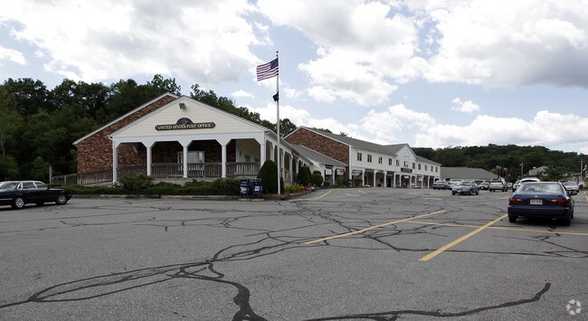
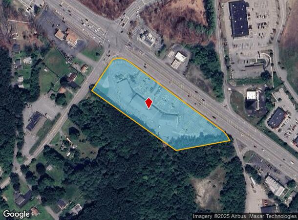
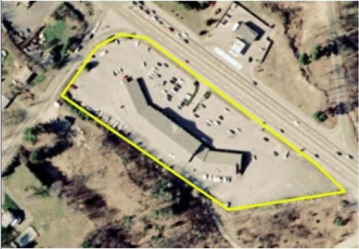
160 Worcester Providence Tpke
Regionalshoppingcenterormallwithanchorstore
Worcester
X
Massachusetts
25027C0836E
4.36 AC
2025
Outlying Worcester
2025
Boston
751101
Worcester, MA
32,618 SF
SUTT-000010-000000-000074
DEMOGRAPHICS near 160 Worcester Providence Tpke
1 Mile
3 Mile
5 Mile
2024 Total Population
1,306
17,486
51,521
2029 Population
1,294
17,388
51,395
Pop Growth 2024-2029
(0.92%)
(0.56%)
(0.24%)
Average Age
43
42
42
2024 Total Households
500
6,964
20,159
HH Growth 2024-2029
(0.80%)
(0.62%)
(0.28%)
Median Household Inc
$120,833
$109,049
$111,876
Avg Household Size
2.60
2.50
2.50
2024 Avg HH Vehicles
2.00
2.00
2.00
Median Home Value
$441,923
$408,874
$419,751
Median Year Built
1981
1973
1976
Nearby Places
Map Layers
Map Styles
 Street
 Aerial
- Restaurants
- Banks
- Shops
- Fitness
- Groceries
PUBLIC TRANSPORTATION
COMMUTER RAIL
Westborough (Framingham/Worcester Line - Massachusetts Bay Transportation Authority Commuter Rail (Purple Line))
DRIVE
WALK
Distance
Westborough (Framingham/Worcester Line - Massachusetts Bay Transportation Authority Commuter Rail (Purple Line))
11 min
7.5 mi
Freight Ports
Port of Boston
DRIVE
WALK
Distance
Port of Boston
1 min
38.7 mi
SALE & LEASE HISTORY
LISTING DATE
SALE/LEASE

Feb 17, 2024
For Lease
Nearby Properties
Address
Land Use
TOTAL SIZE
Lot Size
Zoning
Address
Land Use
TOTAL SIZE
Lot Size
Zoning
423,649 SF
33.23 AC
B2
Address
Land Use
TOTAL SIZE
Lot Size
Zoning
200,557 SF
13.09 AC
R1
Address
Land Use
TOTAL SIZE
Lot Size
Zoning
Address
Land Use
TOTAL SIZE
Lot Size
Zoning
42.92 AC
R1
Address
Land Use
TOTAL SIZE
Lot Size
Zoning
18.10 AC
I1
Address
Land Use
TOTAL SIZE
Lot Size
Zoning
10.19 AC
B2
Address
Land Use
TOTAL SIZE
Lot Size
Zoning
1,628 SF
7.06 AC
Address
Land Use
TOTAL SIZE
Lot Size
Zoning
336,046 SF
36.36 AC
Address
Land Use
TOTAL SIZE
Lot Size
Zoning
109,500 SF
7.40 AC
V
Address
Land Use
TOTAL SIZE
Lot Size
Zoning
32,573 SF
8.25 AC
R2
Address
Land Use
TOTAL SIZE
Lot Size
Zoning
64,848 SF
1.76 AC
I1
Address
Land Use
TOTAL SIZE
Lot Size
Zoning
9.60 AC
I
Address
Land Use
TOTAL SIZE
Lot Size
Zoning
107.27 AC
Address
Land Use
TOTAL SIZE
Lot Size
Zoning
9,200 SF
19.24 AC
I1
Address
Land Use
TOTAL SIZE
Lot Size
Zoning
59,950 SF
6.66 AC
OLI
Address
Land Use
TOTAL SIZE
Lot Size
Zoning
7.47 AC
Address
Land Use
TOTAL SIZE
Lot Size
Zoning
18,450 SF
3.77 AC
B2
Address
Land Use
TOTAL SIZE
Lot Size
Zoning
138.50 AC
I1
Address
Land Use
TOTAL SIZE
Lot Size
Zoning
136.75 AC
R1
Address
Land Use
TOTAL SIZE
Lot Size
Zoning
1,950 SF
506 AC
R1
Address
Land Use
TOTAL SIZE
Lot Size
Zoning
24,315 SF
1.04 AC
B1
Address
Land Use
TOTAL SIZE
Lot Size
Zoning
18,237 SF
1 AC
R1
Address
Land Use
TOTAL SIZE
Lot Size
Zoning
20,941 SF
0.73 AC
B1
Address
Land Use
TOTAL SIZE
Lot Size
Zoning
160.37 AC
Address
Land Use
TOTAL SIZE
Lot Size
Zoning
3.50 AC
R1
Address
Land Use
TOTAL SIZE
Lot Size
Zoning
Address
Land Use
TOTAL SIZE
Lot Size
Zoning
34,635 SF
1.60 AC
RO
Address
Land Use
TOTAL SIZE
Lot Size
Zoning
32,390 SF
1.90 AC
I
Address
Land Use
TOTAL SIZE
Lot Size
Zoning
1.70 AC
The World's #1 Commercial Real Estate Marketplace
Connect with us
© 2026 CoStar Group
The information above has been obtained from sources believed reliable. While we do not doubt its accuracy we have not verified it and make no guarantee, warranty or representation about it. It is your responsibility to independently confirm its accuracy and completeness. Any projections, opinions, assumptions, or estimates used are for example only and do not represent the current or future performance of the property. The value of this transaction to you depends on tax and other factors which should be evaluated by your tax, financial, and legal advisors. You and your advisors should conduct a careful, independent investigation of the property to determine to your satisfaction the suitability of the property for your needs.