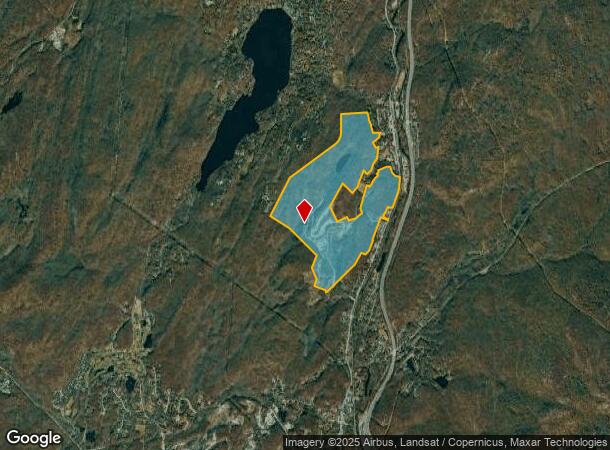
Property Record
Route 17, T O Tuxedo, NY 10987
NEARBY LISTINGS FOR SALE OR LEASE
Property Detail
Route 17
335089-013-000-0006-003.000-0000
Orange
Recreationalacreage
New York
X
34.20
36087C0058G
548.90 AC
2023
Monroe
2024
Northern New Jersey
014900
New York-Jersey City-White Plains, NY-NJ
DEMOGRAPHICS near Route 17
1 Mile
3 Mile
5 Mile
2024 Total Population
1,733
7,293
14,115
2029 Population
1,809
7,644
14,669
Pop Growth 2024-2029
+ 4.39%
+ 4.81%
+ 3.92%
Average Age
44
43
42
2024 Total Households
652
2,690
5,235
HH Growth 2024-2029
+ 4.60%
+ 4.94%
+ 4.03%
Median Household Inc
$113,028
$123,739
$119,230
Avg Household Size
2.60
2.70
2.60
2024 Avg HH Vehicles
2.00
2.00
2.00
Median Home Value
$650,537
$700,854
$591,725
Median Year Built
1974
1966
1965
Nearby Places
Map Layers
Map Styles
 Street
 Aerial
- Restaurants
- Banks
- Shops
- Fitness
- Groceries
PUBLIC TRANSPORTATION
COMMUTER RAIL
Tuxedo (Bergen County/Port Jervis Line - NJ Transit Commuter Rail (NJ Transit), Main/Port Jervis Line - NJ Transit Commuter Rail (NJ Transit))
DRIVE
WALK
Distance
Tuxedo (Bergen County/Port Jervis Line - NJ Transit Commuter Rail (NJ Transit), Main/Port Jervis Line - NJ Transit Commuter Rail (NJ Transit))
8 min
1.9 mi
Sloatsburg (Bergen County/Port Jervis Line - NJ Transit Commuter Rail (NJ Transit), Main/Port Jervis Line - NJ Transit Commuter Rail (NJ Transit))
DRIVE
WALK
Distance
Sloatsburg (Bergen County/Port Jervis Line - NJ Transit Commuter Rail (NJ Transit), Main/Port Jervis Line - NJ Transit Commuter Rail (NJ Transit))
13 min
4.6 mi
AIRPORT
New York Stewart International
DRIVE
WALK
Distance
New York Stewart International
54 min
32.3 mi
Westchester County
DRIVE
WALK
Distance
Westchester County
60 min
39.0 mi
Freight Ports
Port Newark Container Terminal
DRIVE
WALK
Distance
Port Newark Container Terminal
70 min
44.3 mi
Nearby Properties
Address
Land Use
TOTAL SIZE
Lot Size
Zoning
Address
Land Use
TOTAL SIZE
Lot Size
Zoning
4,686 SF
33.17 AC
03
Address
Land Use
TOTAL SIZE
Lot Size
Zoning
1,389.23 AC
Address
Land Use
TOTAL SIZE
Lot Size
Zoning
28,984 SF
20.90 AC
03
Address
Land Use
TOTAL SIZE
Lot Size
Zoning
1,248.30 AC
Address
Land Use
TOTAL SIZE
Lot Size
Zoning
Address
Land Use
TOTAL SIZE
Lot Size
Zoning
22,292 SF
170.28 AC
RR-80
Address
Land Use
TOTAL SIZE
Lot Size
Zoning
123.39 AC
911
Address
Land Use
TOTAL SIZE
Lot Size
Zoning
40.90 AC
911
Address
Land Use
TOTAL SIZE
Lot Size
Zoning
Address
Land Use
TOTAL SIZE
Lot Size
Zoning
490.16 AC
Address
Land Use
TOTAL SIZE
Lot Size
Zoning
Address
Land Use
TOTAL SIZE
Lot Size
Zoning
19 AC
911
Address
Land Use
TOTAL SIZE
Lot Size
Zoning
1,631 SF
1.30 AC
206
Address
Land Use
TOTAL SIZE
Lot Size
Zoning
13.30 AC
911
Address
Land Use
TOTAL SIZE
Lot Size
Zoning
12.60 AC
911
Address
Land Use
TOTAL SIZE
Lot Size
Zoning
659.59 AC
Address
Land Use
TOTAL SIZE
Lot Size
Zoning
10 AC
911
Address
Land Use
TOTAL SIZE
Lot Size
Zoning
3.80 AC
Address
Land Use
TOTAL SIZE
Lot Size
Zoning
9.40 AC
911
Address
Land Use
TOTAL SIZE
Lot Size
Zoning
90,622 SF
9.86 AC
R10
Address
Land Use
TOTAL SIZE
Lot Size
Zoning
290 AC
Address
Land Use
TOTAL SIZE
Lot Size
Zoning
165.60 AC
Address
Land Use
TOTAL SIZE
Lot Size
Zoning
153.90 AC
Address
Land Use
TOTAL SIZE
Lot Size
Zoning
12.60 AC
Address
Land Use
TOTAL SIZE
Lot Size
Zoning
9,574 SF
2.90 AC
Address
Land Use
TOTAL SIZE
Lot Size
Zoning
1,484 SF
1 AC
206
Address
Land Use
TOTAL SIZE
Lot Size
Zoning
75 AC
911
Address
Land Use
TOTAL SIZE
Lot Size
Zoning
389.03 AC
Address
Land Use
TOTAL SIZE
Lot Size
Zoning
3.09 AC
911
The World's #1 Commercial Real Estate Marketplace
Connect with us
© 2025 CoStar Group
The information above has been obtained from sources believed reliable. While we do not doubt its accuracy we have not verified it and make no guarantee, warranty or representation about it. It is your responsibility to independently confirm its accuracy and completeness. Any projections, opinions, assumptions, or estimates used are for example only and do not represent the current or future performance of the property. The value of this transaction to you depends on tax and other factors which should be evaluated by your tax, financial, and legal advisors. You and your advisors should conduct a careful, independent investigation of the property to determine to your satisfaction the suitability of the property for your needs.