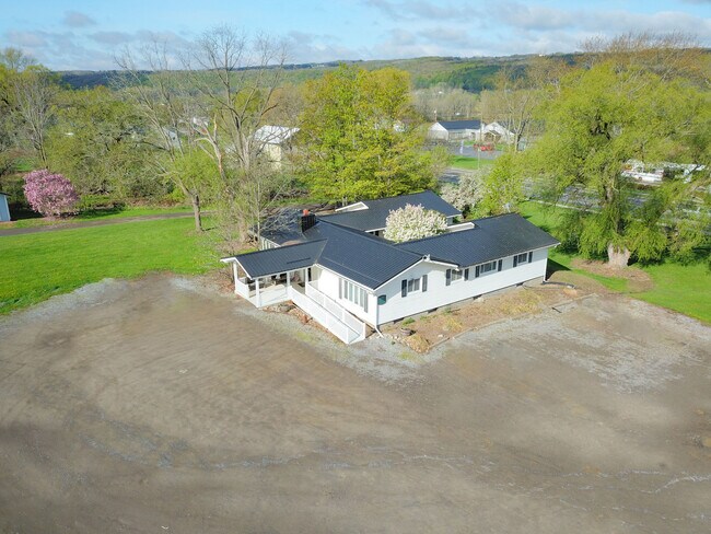
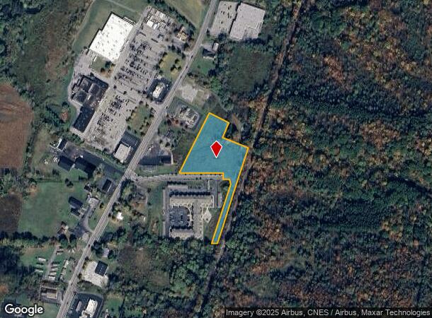
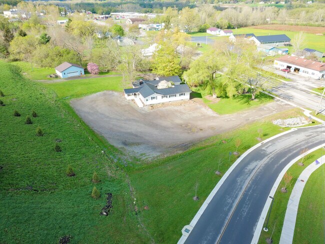
Property Record
Route 19 N, Warsaw, NY 14569
NEARBY LISTINGS FOR SALE OR LEASE
Property Detail
Route 19 N
Other Market Areas
Wyoming
564889 61.-2-71.111
New York
Commercialacreage
71.111
2024
4.36 AC
2024
New York West Area
970500
DEMOGRAPHICS near Route 19 N
1 Mile
3 Mile
5 Mile
2024 Total Population
556
4,924
7,054
2029 Population
551
4,881
6,979
Pop Growth 2024-2029
(0.90%)
(0.87%)
(1.06%)
Average Age
45
44
44
2024 Total Households
235
2,121
2,897
HH Growth 2024-2029
(0.85%)
(0.90%)
(1.00%)
Median Household Inc
$45,385
$47,230
$53,457
Avg Household Size
2.10
2.20
2.20
2024 Avg HH Vehicles
1.00
1.00
2.00
Median Home Value
$139,375
$139,871
$142,222
Median Year Built
1952
1948
1949
Nearby Places
- Restaurants
- Banks
- Shops
- Fitness
- Groceries
SALE & LEASE HISTORY
LISTING DATE
SALE/LEASE

Sep 27, 2021
For Sale
Mar 24, 2023
For Sale
Nearby Properties
Address
Land Use
TOTAL SIZE
Lot Size
Zoning
Address
Land Use
TOTAL SIZE
Lot Size
Zoning
34,085 SF
17.24 AC
02 - SINGL
Address
Land Use
TOTAL SIZE
Lot Size
Zoning
127,224 SF
7.90 AC
Address
Land Use
TOTAL SIZE
Lot Size
Zoning
110,100 SF
13.93 AC
02 - SINGL
Address
Land Use
TOTAL SIZE
Lot Size
Zoning
Address
Land Use
TOTAL SIZE
Lot Size
Zoning
75,167 SF
27.31 AC
05 - COMME
Address
Land Use
TOTAL SIZE
Lot Size
Zoning
31,057 SF
2.37 AC
05 - COMME
Address
Land Use
TOTAL SIZE
Lot Size
Zoning
Address
Land Use
TOTAL SIZE
Lot Size
Zoning
41,904 SF
0.08 AC
02 - SINGL
Address
Land Use
TOTAL SIZE
Lot Size
Zoning
89,362 SF
7.33 AC
02 - SINGL
Address
Land Use
TOTAL SIZE
Lot Size
Zoning
31,450 SF
2.44 AC
02 - SINGL
Address
Land Use
TOTAL SIZE
Lot Size
Zoning
Address
Land Use
TOTAL SIZE
Lot Size
Zoning
45,533 SF
15.29 AC
05 - COMME
Address
Land Use
TOTAL SIZE
Lot Size
Zoning
Address
Land Use
TOTAL SIZE
Lot Size
Zoning
Address
Land Use
TOTAL SIZE
Lot Size
Zoning
Address
Land Use
TOTAL SIZE
Lot Size
Zoning
Address
Land Use
TOTAL SIZE
Lot Size
Zoning
Address
Land Use
TOTAL SIZE
Lot Size
Zoning
Address
Land Use
TOTAL SIZE
Lot Size
Zoning
Address
Land Use
TOTAL SIZE
Lot Size
Zoning
Address
Land Use
TOTAL SIZE
Lot Size
Zoning
Address
Land Use
TOTAL SIZE
Lot Size
Zoning
Address
Land Use
TOTAL SIZE
Lot Size
Zoning
Address
Land Use
TOTAL SIZE
Lot Size
Zoning
Address
Land Use
TOTAL SIZE
Lot Size
Zoning
Address
Land Use
TOTAL SIZE
Lot Size
Zoning
Address
Land Use
TOTAL SIZE
Lot Size
Zoning
Address
Land Use
TOTAL SIZE
Lot Size
Zoning
Address
Land Use
TOTAL SIZE
Lot Size
Zoning
Address
Land Use
TOTAL SIZE
Lot Size
Zoning
The World's #1 Commercial Real Estate Marketplace
Connect with us
© 2025 CoStar Group
The information above has been obtained from sources believed reliable. While we do not doubt its accuracy we have not verified it and make no guarantee, warranty or representation about it. It is your responsibility to independently confirm its accuracy and completeness. Any projections, opinions, assumptions, or estimates used are for example only and do not represent the current or future performance of the property. The value of this transaction to you depends on tax and other factors which should be evaluated by your tax, financial, and legal advisors. You and your advisors should conduct a careful, independent investigation of the property to determine to your satisfaction the suitability of the property for your needs.