Property Record
43W368 Rte 20, Hampshire, IL 60140
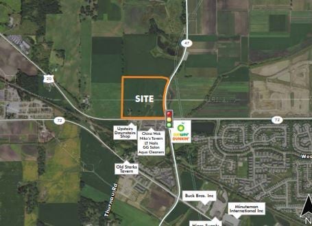
This Property Is For Sale
Property Detail
43W368 Rte 20
Chicago-Naperville-Elgin, IL-IN
PT S1/2 NE1/4 SEC 30-42-7 W ROAD DESC IN DOC 2001K047354 (EX PT DESC IN DOC 2008K067757 & EX PT FOR RD DESC IN CO 13ED10 PROCESSED AS 14DIV129 AND RECORDED IN 2016 AS 2016K052715 (16DIV355) & 2016K052714 (16DIV356) NEITHER 2016 DEED REQUIRED WORK TO
02-30-200-015
KANE
Farms
Illinois
B and X Area of moderate flood hazard, usually the area between the limits of the 100-year and 500-year floods.
33.98 AC
2024
Far Northwest
2024
Chicago
850705
NEARBY LISTINGS FOR SALE OR LEASE
DEMOGRAPHICS near 43W368 Rte 20
1 mile
3 mile
5 mile
2025 Total Population
5,173
17,793
43,424
2030 Population
5,260
18,283
44,634
Pop Growth 2025-2030
+ 1.68%
+ 2.75%
+ 2.79%
Average Age
36
38
46
2025 Total Households
1,722
6,104
17,060
HH Growth 2025-2030
+ 1.86%
+ 2.90%
+ 2.71%
Median Household Inc
$125,490
$119,837
$103,951
Avg Household Size
3.00
2.90
2.50
2025 Avg HH Vehicles
2.00
2.00
2.00
Median Home Value
$318,588
$343,011
$348,200
Median Year Built
2008
2006
2004
Nearby Places
Map Layers
Map Styles
 Street
 Aerial
Layers
 Traffic
 Biking
Places
Listings with unknown addresses are not visible on the map
- Restaurants
- Banks
- Shops
- Fitness
- Groceries
PUBLIC TRANSPORTATION
COMMUTER RAIL
Big Timber Road Station (Milwaukee District West Line - Northeast Illinois Regional Commuter Railroad (Metra))
Drive
Walk
Distance
Big Timber Road Station (Milwaukee District West Line - Northeast Illinois Regional Commuter Railroad (Metra))
13 min
8.1 mi
AIRPORT
Chicago O'Hare International
Drive
Walk
Distance
Chicago O'Hare International
44 min
36.5 mi
Freight Ports
Port Milwaukee
Drive
Walk
Distance
Port Milwaukee
121 min
84.3 mi
Nearby Properties
Address
Land Use
TOTAL SIZE
Lot Size
Zoning
Address
Land Use
TOTAL SIZE
Lot Size
Zoning
Address
Land Use
TOTAL SIZE
Lot Size
Zoning
57.30 AC
Address
Land Use
TOTAL SIZE
Lot Size
Zoning
Address
Land Use
TOTAL SIZE
Lot Size
Zoning
10.30 AC
Address
Land Use
TOTAL SIZE
Lot Size
Zoning
15.02 AC
Address
Land Use
TOTAL SIZE
Lot Size
Zoning
89,940 SF
8.93 AC
Address
Land Use
TOTAL SIZE
Lot Size
Zoning
Address
Land Use
TOTAL SIZE
Lot Size
Zoning
14.26 AC
Address
Land Use
TOTAL SIZE
Lot Size
Zoning
Address
Land Use
TOTAL SIZE
Lot Size
Zoning
44,800 SF
35.39 AC
M2 MANUFAC
Address
Land Use
TOTAL SIZE
Lot Size
Zoning
Address
Land Use
TOTAL SIZE
Lot Size
Zoning
Address
Land Use
TOTAL SIZE
Lot Size
Zoning
101,250 SF
17.98 AC
Address
Land Use
TOTAL SIZE
Lot Size
Zoning
58,400 SF
10.26 AC
Address
Land Use
TOTAL SIZE
Lot Size
Zoning
Address
Land Use
TOTAL SIZE
Lot Size
Zoning
Address
Land Use
TOTAL SIZE
Lot Size
Zoning
22,502 SF
4.92 AC
Address
Land Use
TOTAL SIZE
Lot Size
Zoning
Address
Land Use
TOTAL SIZE
Lot Size
Zoning
3.35 AC
Address
Land Use
TOTAL SIZE
Lot Size
Zoning
15.59 AC
Address
Land Use
TOTAL SIZE
Lot Size
Zoning
Address
Land Use
TOTAL SIZE
Lot Size
Zoning
Address
Land Use
TOTAL SIZE
Lot Size
Zoning
16.90 AC
Address
Land Use
TOTAL SIZE
Lot Size
Zoning
1.22 AC
Address
Land Use
TOTAL SIZE
Lot Size
Zoning
20,040 SF
3.96 AC
Address
Land Use
TOTAL SIZE
Lot Size
Zoning
1.51 AC
Address
Land Use
TOTAL SIZE
Lot Size
Zoning
18,000 SF
4.62 AC
Address
Land Use
TOTAL SIZE
Lot Size
Zoning
2.01 AC
The World's #1 Commercial Real Estate Marketplace
Connect with us
© 2026 CoStar Group
The information above has been obtained from sources believed reliable. While we do not doubt its accuracy we have not verified it and make no guarantee, warranty or representation about it. It is your responsibility to independently confirm its accuracy and completeness. Any projections, opinions, assumptions, or estimates used are for example only and do not represent the current or future performance of the property. The value of this transaction to you depends on tax and other factors which should be evaluated by your tax, financial, and legal advisors. You and your advisors should conduct a careful, independent investigation of the property to determine to your satisfaction the suitability of the property for your needs.