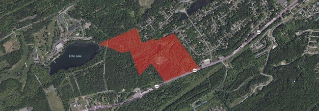
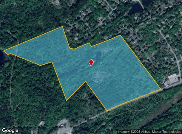
Property Record
Milford Rd, East Stroudsburg, PA 18302
NEARBY LISTINGS FOR SALE OR LEASE
Property Detail
Milford Rd
09.3.1.5-1
209 Builders
Forest
Monroe
A
Pennsylvania
42089C0308E
54.86 AC
2025
Monroe County
2025
Philadelphia
301405
East Stroudsburg, PA
DEMOGRAPHICS near Milford Rd
1 Mile
3 Mile
5 Mile
2024 Total Population
1,315
9,391
32,503
2029 Population
1,302
9,333
32,196
Pop Growth 2024-2029
(0.99%)
(0.62%)
(0.94%)
Average Age
43
42
41
2024 Total Households
466
3,448
11,449
HH Growth 2024-2029
(1.07%)
(0.61%)
(0.77%)
Median Household Inc
$103,350
$90,890
$88,150
Avg Household Size
2.70
2.60
2.70
2024 Avg HH Vehicles
2.00
2.00
2.00
Median Home Value
$249,375
$245,371
$227,269
Median Year Built
1993
1988
1986
Nearby Places
Map Layers
Map Styles
 Street
 Aerial
- Restaurants
- Banks
- Shops
- Fitness
- Groceries
SALE & LEASE HISTORY
LISTING DATE
SALE/LEASE

Oct 07, 2022
For Sale
Nearby Properties
Address
Land Use
TOTAL SIZE
Lot Size
Zoning
Address
Land Use
TOTAL SIZE
Lot Size
Zoning
878.01 AC
CON
Address
Land Use
TOTAL SIZE
Lot Size
Zoning
40,605 SF
16.80 AC
C1
Address
Land Use
TOTAL SIZE
Lot Size
Zoning
73,064 SF
61.02 AC
C2
Address
Land Use
TOTAL SIZE
Lot Size
Zoning
12,381 SF
6.53 AC
C1
Address
Land Use
TOTAL SIZE
Lot Size
Zoning
1,460 SF
1,203.19 AC
CON
Address
Land Use
TOTAL SIZE
Lot Size
Zoning
4,606 SF
3.52 AC
C1
Address
Land Use
TOTAL SIZE
Lot Size
Zoning
7,111 SF
7.79 AC
C1
Address
Land Use
TOTAL SIZE
Lot Size
Zoning
15,652 SF
2.33 AC
C1
Address
Land Use
TOTAL SIZE
Lot Size
Zoning
3,338 SF
1.91 AC
C1
Address
Land Use
TOTAL SIZE
Lot Size
Zoning
31,812 SF
15.99 AC
C1
Address
Land Use
TOTAL SIZE
Lot Size
Zoning
15,509 SF
5.26 AC
C1
Address
Land Use
TOTAL SIZE
Lot Size
Zoning
5,040 SF
5.58 AC
C1
Address
Land Use
TOTAL SIZE
Lot Size
Zoning
15,778 SF
7 AC
PRD
Address
Land Use
TOTAL SIZE
Lot Size
Zoning
24,266 SF
5.74 AC
C1
Address
Land Use
TOTAL SIZE
Lot Size
Zoning
15,021 SF
17.59 AC
C1
Address
Land Use
TOTAL SIZE
Lot Size
Zoning
3,820 SF
320.53 AC
C2
Address
Land Use
TOTAL SIZE
Lot Size
Zoning
1,800 SF
55.19 AC
C1
Address
Land Use
TOTAL SIZE
Lot Size
Zoning
28,484 SF
3.22 AC
C1
Address
Land Use
TOTAL SIZE
Lot Size
Zoning
18,970 SF
9.81 AC
C1
Address
Land Use
TOTAL SIZE
Lot Size
Zoning
3,276 SF
40.23 AC
R3
Address
Land Use
TOTAL SIZE
Lot Size
Zoning
10,175 SF
2.57 AC
C1
Address
Land Use
TOTAL SIZE
Lot Size
Zoning
1,024 SF
82 AC
C1
Address
Land Use
TOTAL SIZE
Lot Size
Zoning
3,024 SF
1.74 AC
C1
Address
Land Use
TOTAL SIZE
Lot Size
Zoning
9,135 SF
64.26 AC
R2
Address
Land Use
TOTAL SIZE
Lot Size
Zoning
5,924 SF
126 AC
C1
Address
Land Use
TOTAL SIZE
Lot Size
Zoning
7,500 SF
2.51 AC
C1
Address
Land Use
TOTAL SIZE
Lot Size
Zoning
23.60 AC
C1
Address
Land Use
TOTAL SIZE
Lot Size
Zoning
4,722 SF
3.40 AC
C1
Address
Land Use
TOTAL SIZE
Lot Size
Zoning
47.94 AC
CON
Address
Land Use
TOTAL SIZE
Lot Size
Zoning
6,720 SF
6.71 AC
C1
The World's #1 Commercial Real Estate Marketplace
Connect with us
© 2025 CoStar Group
The information above has been obtained from sources believed reliable. While we do not doubt its accuracy we have not verified it and make no guarantee, warranty or representation about it. It is your responsibility to independently confirm its accuracy and completeness. Any projections, opinions, assumptions, or estimates used are for example only and do not represent the current or future performance of the property. The value of this transaction to you depends on tax and other factors which should be evaluated by your tax, financial, and legal advisors. You and your advisors should conduct a careful, independent investigation of the property to determine to your satisfaction the suitability of the property for your needs.