Property Record
Abers Creek Rd, Monroeville, PA 15146

Property Detail
Abers Creek Rd
Pittsburgh, PA
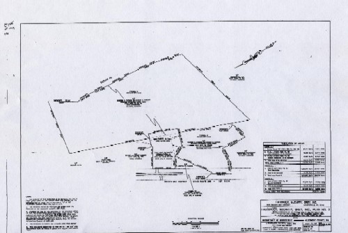
BEAMSLEY PLAN OF LOTS NO 2 R.O.W. = ABERS CREEK RD
1243-A-00151-0000-00
ALLEGHENY
Easement
Pennsylvania
B and X Area of moderate flood hazard, usually the area between the limits of the 100-year and 500-year floods.
151
2023
0.57 AC
2025
Monroeville
521302
Pittsburgh
NEARBY LISTINGS FOR SALE OR LEASE
DEMOGRAPHICS near Abers Creek Rd
1 mile
3 mile
5 mile
2025 Total Population
3,565
33,800
77,782
2030 Population
3,495
33,174
76,550
Pop Growth 2025-2030
(1.96%)
(1.85%)
(1.58%)
Average Age
45
46
45
2025 Total Households
1,544
14,254
32,933
HH Growth 2025-2030
(2.07%)
(1.93%)
(1.66%)
Median Household Inc
$95,223
$98,979
$90,362
Avg Household Size
2.20
2.30
2.30
2025 Avg HH Vehicles
2.00
2.00
2.00
Median Home Value
$234,553
$254,198
$240,125
Median Year Built
1973
1970
1968
Nearby Places
Map Layers
Map Styles
 Street
 Aerial
Transit
 Traffic
 Biking
Places
Listings with unknown addresses are not visible on the map
- Restaurants
- Banks
- Shops
- Fitness
- Groceries
PUBLIC TRANSPORTATION
AIRPORT
Arnold Palmer Regional
Drive
Walk
Distance
Arnold Palmer Regional
47 min
27.7 mi
Pittsburgh International
Drive
Walk
Distance
Pittsburgh International
50 min
34.2 mi
Freight Ports
Port of Baltimore
Drive
Walk
Distance
Port of Baltimore
277 min
236.9 mi
SALE & LEASE HISTORY
LISTING DATE
SALE/LEASE

Jan 21, 2020
For Sale
Nearby Properties
Address
Land Use
TOTAL SIZE
Lot Size
Zoning
Address
Land Use
TOTAL SIZE
Lot Size
Zoning
16.27 AC
Address
Land Use
TOTAL SIZE
Lot Size
Zoning
Address
Land Use
TOTAL SIZE
Lot Size
Zoning
1,274 SF
115.40 AC
Address
Land Use
TOTAL SIZE
Lot Size
Zoning
Address
Land Use
TOTAL SIZE
Lot Size
Zoning
46.31 AC
Address
Land Use
TOTAL SIZE
Lot Size
Zoning
Address
Land Use
TOTAL SIZE
Lot Size
Zoning
13.10 AC
Address
Land Use
TOTAL SIZE
Lot Size
Zoning
Address
Land Use
TOTAL SIZE
Lot Size
Zoning
Address
Land Use
TOTAL SIZE
Lot Size
Zoning
25.80 AC
Address
Land Use
TOTAL SIZE
Lot Size
Zoning
50.13 AC
Address
Land Use
TOTAL SIZE
Lot Size
Zoning
30.94 AC
Address
Land Use
TOTAL SIZE
Lot Size
Zoning
Address
Land Use
TOTAL SIZE
Lot Size
Zoning
Address
Land Use
TOTAL SIZE
Lot Size
Zoning
53.85 AC
Address
Land Use
TOTAL SIZE
Lot Size
Zoning
53.05 AC
Address
Land Use
TOTAL SIZE
Lot Size
Zoning
11.65 AC
Address
Land Use
TOTAL SIZE
Lot Size
Zoning
Address
Land Use
TOTAL SIZE
Lot Size
Zoning
Address
Land Use
TOTAL SIZE
Lot Size
Zoning
1,436 SF
949.42 AC
Address
Land Use
TOTAL SIZE
Lot Size
Zoning
Address
Land Use
TOTAL SIZE
Lot Size
Zoning
Address
Land Use
TOTAL SIZE
Lot Size
Zoning
15.40 AC
Address
Land Use
TOTAL SIZE
Lot Size
Zoning
1,712 SF
4.55 AC
Address
Land Use
TOTAL SIZE
Lot Size
Zoning
21.07 AC
Address
Land Use
TOTAL SIZE
Lot Size
Zoning
Address
Land Use
TOTAL SIZE
Lot Size
Zoning
Address
Land Use
TOTAL SIZE
Lot Size
Zoning
4.23 AC
Address
Land Use
TOTAL SIZE
Lot Size
Zoning
Address
Land Use
TOTAL SIZE
Lot Size
Zoning
1,274 SF
105.63 AC
The World's #1 Commercial Real Estate Marketplace
Connect with us
© 2026 CoStar Group
The information above has been obtained from sources believed reliable. While we do not doubt its accuracy we have not verified it and make no guarantee, warranty or representation about it. It is your responsibility to independently confirm its accuracy and completeness. Any projections, opinions, assumptions, or estimates used are for example only and do not represent the current or future performance of the property. The value of this transaction to you depends on tax and other factors which should be evaluated by your tax, financial, and legal advisors. You and your advisors should conduct a careful, independent investigation of the property to determine to your satisfaction the suitability of the property for your needs.